For the second day of our backpacking trip we had originally planned on hiking up to Bear Lake from our campsite at Eagle Creek Meadow then returning to camp to pack up and move closer to the Bench Trail. After reestablishing camp we would then take the Bench Trail up to Arrow Lake in the afternoon/evening. We had spotted a couple of workable campsites on our way by the day before (post), but Heather had already decided by the end of that day that she would be skipping the out-and-back to Arrow Lake due to the heat.
As we set off for Bear Lake at 6:15am I was still considering attempting to reach Arrow Lake. It had actually been cool enough at camp that morning for me to put on my beanie and thicker gloves.

 Doe on the other side of Eagle Creek.
From our campsite we made our way to the Lookingglass Trail and the ford of Eagle Creek. We’d seen some hikers crossing the ford the day before. They had all used their water shoes for the ford and Heather planned on doing the same. I don’t have a pair myself, so I had the choice of fording in my trail runners or making an attempt to cross on logs/rocks. I chose to try and keep my feet dry.
 I started out on the small logs shown here.
Somehow I managed to make it across and after Heather changed into her hiking boots we started uphill.

We made it approximately 100 yards before realizing that I had left my car key and wallet in the tent and Heather had left her phone. I turned around and headed back to retrieve the forgotten items. After two more dry crossings I caught back up to Heather and we continued uphill toward a junction with the Bear Lake Trail.
 Here comes the Sun.
 Shade for us for now though.
 The junction up ahead.
 We arrived at the junction roughly three quarters of a mile and 650′ up from camp.
We turned onto the Bear Lake Trail which continued to climb but more gradually. After another third of a mile we took a side trail toward Culver Lake. The first trail we tried led to a marsh where a doe was having her breakfast.

 Not many mushrooms of fungi along the trails but we spotted a few along this trail.
 Globe penstemon


The lake proved unreachable from this first trail so we returned to the Bear Lake Trail and quickly found another side trail which did lead to Culver Lake.
 Cairn marking the trail to Culver Lake.


 Snow patch along Culver Lake.

We took a break at the lake. It was already getting warm and I finally decided that I was not going to be attempting the 2000′ climb to Arrow Lake later in the day. It was not necessary in order for us to check off any featured hikes and I didn’t want to risk overexerting myself when we had three more lakes to visit over the next couple of days. Our new plan was to return to camp after visiting Bear Lake, pack up and hike out, then drive to the West Eagle Meadows Trailhead. There we could either camp at the West Eagle Meadow Campground, or hike in 3ish miles and hope to find a suitable campsite. We would make our choice later on when we had a better idea of how we were feeling.
After admiring the lake we returned to the Bear Lake Trail which gained another 200 plus feet before dropping to Bear Lake after half a mile.

 Needle Point from the trail.
 Nuttall’s linanthus
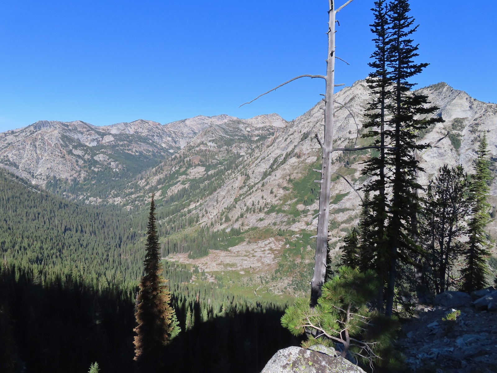 Arrow Lake is somewhere up in the mountains on the other side of the valley.
 View down the Eagle Creek Valley.
 Rock Creek Butte in the Elkhorns (post).
 Heading down.
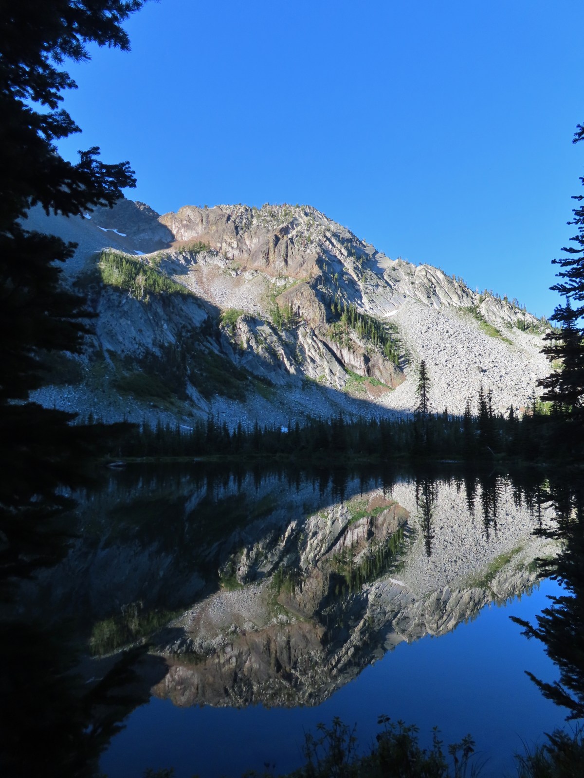
 Bear Lake
We made our way a little way around Bear Lake to see it from some different angles.
 Mountain heather.
 Cusick’s speedwell

 Aster and swamp onion
 Arnica and possibly alpine leafybract aster.
 A bunch of globe penstemon.
 Meadow at the eastern end of Bear Lake.
 Needle Point from Bear Lake.
We scrambled up some granite to a viewpoint above the lake.
 Looking toward Eagle Lake in the basin behind and right of Needle Point.
 Eagle Creek is down there somewhere.
 Eagle Creek Meadow. The Main Eagle Trail can be seen crossing the granite slope at the far end of the meadow.
We headed back down toward camp prepared to pack up and hike out.

 Allum root
 White mariposa lily
 The Sun had reached the valley by the time we were nearing Eagle Creek.
 The Eagle Creek crossing going the other direction. I’m happy (and amazed) to report that I managed a fourth dry crossing.
We packed up camp and replenished our water supply before setting off for the trailhead. It was roughly 4.5 miles back to the car where the temperature was (according to the car) 91 degrees.
 Lupin along Eagle Creek where we topped off our water.
 Hummingbird Mountain
 Mountain coyote mint
 Falls on the far side of the valley. Probably the outlet creek of Lookingglass Lake.
 Nearing the Bench Trail junction.
 Copper Creek Falls from the trail.
 Small cascade along the trail.
 Wallflower, this was the only one we spotted all trip.
 Damaged footbridge over Eagle Creek.
 Buck crossing the trail.

 Swallowtail on nettle-leaf giant hyssop.
 Bridge over Eagle Creek.
I arrived at the large bridge over Eagle Creek first and decided to bushwack up the creek a short distance to what turned out to be a really nice waterfall.


 Back at the Main Eagle Trailhead.
It was 2pm when we arrived back at the car and headed for the West Eagle Meadows Trailhead. Sullivan had mentioned that the final 3.2 miles were bumpy and very slow, but it appeared that the Forest Service had been working on it and we only had a few smaller sections of rough 10mph road.
It felt every bit of 91 when we arrived at the trailhead where we searched for shaded places to sit.

We had decided not to spend the night in the campground but rather to make the 3ish mile hike to a crossing of West Eagle Creek where we hoped we’d find a campsite. Our latest version of the plan for the rest of our trip was to cut it a day short. Hiking in the 3ish miles now would leave a challenging out-and-back to Tombstone Lake for Wednesday then a 9.5-mile out-and-back to Echo and Traverse Lakes on Thursday which could be combined with the 3ish-mile hike back to the trailhead on Thursday allowing us to hopefully get home sometime Thursday evening.
We stuck around the trailhead long enough to cook an early dinner then set off a little after 4:30pm in search of a campsite.
 West Eagle Trail
The West Eagle Trail passed a series of walk-in tent campsites along West Eagle Meadows before entering the forest.
 One of the campsites.
 Mule Peak behind to the right and Wolf Point furthest back center.
 Nettle-leaf giant hyssop
 Painted lady on the hyssop.
 Frittilary butterfly
 Approaching the trees.
 The decommissioned Fake Creek Trail to the right at the 0.6-mile mark.
 Fake Creek crossing.

 Squirrel
 Unnamed creek crossing.
 Lewis monkeyflower
 Entering the Eagle Cap Wilderness at West Eagle Creek.
 West Eagle Creek Crossing. I almost made it across this one dry footed too but one of the rocks on the far side was unstable causing me to drag my right toe in the creek.
 Trail maintenance.
Beyond the creek crossing the trail passed through a series of small meadows as it climbed to the second crossing of West Eagle Creek.

 Coneflower

 Reentering the trees after passing through a meadow.
 West Eagle Creek
 Another small meadow.
 West Eagle Creek near the second crossing.
We were starting to worry that we might not find a decent camp site but there was one workable site on the near side of the creek. I took my pack off there and crossed the creek to see if there was anything better on the far side and was happy to find a very nice established site not far up the trail.

The campsite was approximately 2.5-miles from the trailhead which would add about a mile to each of the remaining days, but we could tell by the topo maps that there wasn’t likely to be another suitable campsite. We were also pooped and had no desire to hike any further with our full packs. It was close to 6:30pm by the time we had camp set up then we refilled our water once again before heading to bed.
The hike to Bear Lake and back to the Main Eagle Trailhead had been 9.3-miles with 1250′ of elevation gain and we wound up doing close to another 3-miles and 580′ of elevation gain from the West Eagle Meadows Trailhead by the time we were done for the day.

The plan for the next day was still a bit up in the air. I knew I would be heading for Tombstone Lake, but Heather was deciding between heading toward Tombstone Lake or Echo and Traverse Lakes. The hike to Tombstone Lake required approximately 3000′ of cumulative elevation gain (2200′ if she turned back at the pass above the lake), while the hike to Traverse Lake gained about half as much elevation and was nearly 3.5-miles shorter. She would decide in the morning based on how she felt after another night’s sleep. Happy Trails!
Flickr: Bear Lake


 The trail briefly followed an old roadbed.
 Log bridge over Boulder Creek.


 Sierra larkspur
 Paintbrush lined trail
 We were in the shade for most of the morning.
 Entering the Eagle Cap Wilderness.
 We had to leave the trail to get a view of the falls which we could hear from the trail.

 Buckwheat and nettle-leaf giant hyssop
 At the 2.7-mile mark the trail again crossed Eagle Creek, this time on a damaged footbridge.
 Part of the falls were visible from the trail.
 Copper Creek Falls
 Penstemon
 Fringed grass of parnassus and some fading arnica.
 Flowers below the falls.
 The Bench Trail is ahead on the left of the Main Eagle Trail.
 View up the valley.
 Looking back at the hillside the Bench Trail climbs to Heart and Arrow Lakes.
 Looking across the valley.
 There was quite a bit of western snakeroot along the trail.
 Scarlet gilia
 Hummingbird Mountain
 Granite hillside and peaks above the trail.
 Trail signs at the Lookingglass Lake/Main Eagle Trail junction.
 Needle Point on the left from Eagle Creek Meadow.
 Hummingbird Mountain from the campsite.
 Eagle Creek near camp.
 Lewis monkeyflower

 Columbian ground squirrel
 Pearly everlasting and Scouler’s St. John’s wort.
 White mariposa lilies
 White mariposa lilies
 Orange agoseris
 Beetle on a white mariposa lily
 Hillside along the trail.
 Butterfly (Boisduval’s blue?) on pearly everlasting.
 Monkshood
 Heading toward Needle Point.
 One of the switchbacks.
 This junction was just under 2-miles from the Lookingglass Lake Trail junction.
 Wildflowers along the trail.
 Looking back down the valley.
 Hawk
Hawk Fireweed along the trail.
 Shrubby cinquefoil and paintbrush
 Wildfire smoke creating a slight haze of the valley.
 Granite near Eagle Lake.
 Eagle Lake
 Eagle Creek flowing below the dam at Eagle Lake.


 Paintbrush
 While sitting in the shade we spotted a herd of elk on the hillside across the valley.
 Blurry photos due to the distance but it was fun to watch them.

 Golden-mantled ground squirrel
 Shade!
 American saw-wort
 Fawns
Fawns Our campsite in the trees from the Main Eagle Trail.
