I spent some time recently looking through the Oregon Hikers Field Guide looking for shorter hikes, preferably under 6-miles, within an hour and a half of Salem. I wanted to make the most of my currently being limited on distance while I work through my leg/hips/lower back issues. One of the hikes that I found an entry for is the Hopkins Demonstration Forest. The Field Guide describes a 4.2-mile loop with 715′ of elevation gain with a number of options to shorten or lengthen the visit using the network of trails on the 140-acre property.
The forest is located in the foothills of the Old Cascade Mountains approximately 11-miles SE of Oregon City, 11-miles E of Canby, 12-miles N of Molalla and an hour from Salem. The property is run by the non-profit Forests Forever, Inc. and is home to the relocated Clatskanie Mountain Fire Tower as well as the also relocated Molalla Log House. The latter is almost certainly the oldest surviving building in Oregon if not the entire Pacific Northwest. The forest is open 7 days a week during daylight hours however please note that logging activities do close trails/roads from time to time. An event hall, amphitheater, interpretive signs and other guided tours make this a great destination for school field trips or other events.
I was on my own today due to Heather unfortunately waking up to a massive headache. I arrived at the large parking lot next to the event cneter and fire tower at 6:30am.


The event center.

The Clatskanie Mountain Fire Tower was built in 1954 atop 2081′ Clatskanie Mountain in the Oregon Coast Range.
I began by following the Oregon Hikers Field Guide entry which led me downhill from the parking lot to a kiosk with several interpretive signs.


One of the signs was this helpful map. I had downloaded the Field Guide map and the online map from the Hopkins Demonstration Forest website, but you can never have too many maps, so I took a picture with my phone.
From the kiosk I continued downhill on gravel Grouse Hollow Road past an outhouse to another information signboard and donation box.

The rest room on the left.

Tough-leaved iris

Beyond the donation box I passed through a green gate on Grouse Hollow Road and at this point I decided to hike in the opposite direction from the Field Guide and turned right onto the signed Hopkins Trail.


The Hopkins Trail led through a “mature forest” demonstration area to the Cedar Shelter picnic area.


Thimbleberry

Fringecup

Passing through a thinned section. There are similar signs throughout the forest providing information on when and what has been done to the surrounding forest.

Possibly thin-leafed pea.

Honeysuckle

Starflower

The Hopkins Trail continued on the far side of the picnic area and quickly passed the amphitheater.


Beyond the amphitheater the forest demonstration type changed to “thinning and pruning” and Hopkins Trail passed a Big Leaf Maple Tapping Project.


Yes, maple syrup can be made from these trees.
A short distance later I arrived at a junction with the Pacific Madrone Trail where I forked right.

The Pacific Madrone Trail was a narrower trail that climbed up and over a rocky ridge end with a bench and several madrone trees. The forest demonstration type along this trail was “young-stand management”.


The unmistakable trunks of Pacific madrone trees ahead.

The bench under the madrones.

Pacific Madrone
The Pacific Madrone Trail descended from the ridge and ended at Low Gear Road. I had options here for shorter loops by either heading back to the left on Low Gear Road, taking the Shortcut Trail on the opposite side of Low Gear Road, or turning right for a longer loop. I turned right and followed it downhill and around a bend to a junction with Grouse Hollow 

Plumed Solomon’s seal

The junction with Grouse Hollow Road.
I turned right onto Grouse Hollow Road and quickly arrived at another informational kiosk.

After checking out the interpretive signs I continued past a gate on the road.

Approximately 200 feet beyond the gate I came to the signed Redwood Loop Trail which was only shown on the map I’d taken a picture of back near the trailhead.

I turned up this 0.1-mile trail and followed it through an “uneven-aged management” demonstration area.


Starry Solomon’s seal

Dropping back down to Grouse Hollow Road.
I turned right on Grouse Hollow Road to continue the loop. The road continued downhill as it bent around to the NE.


One of several informative signs along Grouse Hollow Road.


Grouse Hollow Road ended in a grassy clearing at a sign for the Uneven Age Trail.


The Field Guide route follows the Uneven Age Trail (albeit coming from the other direction) and doesn’t mention the unnamed trail leading to Little Buckner Creek and a small waterfall. I took this unnamed trail down to the creek.


The trail became a bit rough just before reaching the little waterfall.


The small waterfall.
Now a smart person would have gone back the way they’d come but a rough trail continued uphill from the falls.

The trail was a bit steep but not too hard to follow until I neared the Uneven Age Trail. I was close enough to see a jogger pass by through the trees when I started seeing an increase in poison oak. While I was wearing long pants, sleeves and gloves I did some contorting to try and avoid brushing against it.

Poison oak stretching across the use trail.

Safe on the Uneven Age Trail.
I turned right on the Uneven Age Trail and came to a railed boardwalk followed by a clearcut.


The Uneven Age Trail ended at the West Loop Watershed Trail where I again stayed right.

This trail passed by a clearcut and ended at a junction with Down Creek Road and the Middle Loop Watershed Trail.

Lots of bleeding heart in the clearcut.

I veered right onto the Middle Loop Watershed Trail but veered downhill on another unnamed trail to visit the creek again.


After visiting the creek I returned to the Middle Loop Watershed Trail and continued on my loop. The trail initially passed between the clearcut and the creek before leaving the clearcut behind.


Youth-on-age


Violets


Bent tree
The trail ended at another clearcut at Up Creek Road.


Trillium

Up Creek Road
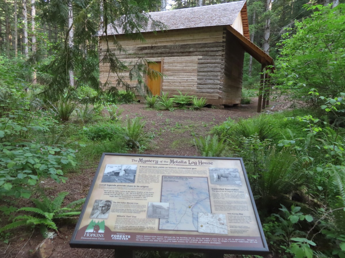
I detoured from the loop here to visit the Molalla Log House. I turned left on Up Creek Road staying right at junctions to another informational kiosk.

I continued uphill on Up Creek Road past the RedCedar Trail to a junction with the Ponds Trail.


I turned left on the Ponds Trail to check out the ponds then headed right toward the visible log house.


The log house through the trees on the right.

I walked around the house looking at the interpretive signs before returning back down to Up Creek Road via the Pond Access Road and resumed my loop.


Spotted towhee
Just beyond the junction with the Middle Loop Watershed Trail I came to the Little Buckner Creek Trail which I turned down.

This trail crossed Little Buckner Creek on a footbridge and climbed through a “reforestation” demonstration area.


Pacific waterleaf


Turkey tails
The Little Buckner Creek Trail ended at the East Loop Watershed Trail where I turned right.

The East Loop Watershed Trail followed Little Buckner Creek for a bit before crossing on another footbridge.


False lily-of-the-valley

I paused on the other side of the bridge to talk to a hiker out with her two cats. Continuing on I followed the trail uphill to its end at Up Creek Road.


Roads made a small loop here and I stayed right and quickly arrived at a sign for Post Road where I turned right.


I detoured down a short spur trail to a viewing platform


Wetlands along Little Buckner Creek from the viewing platform.
Post Road climbed to a junction with the Hardwoods Trail. This trail provides a shortcut back to the trailhead. The Oregon Hikers Field Guide skips this shortcut, but I did not.


The Hardwoods Trail ended at a 3-way junction with the Sawmill and Red Alder Trails.

I turned right onto the Red Alder Trail. This trail climbed, crossing Grouse Hollow Road near the forest entrance, and continued another 375′ to the parking lot near the fire tower.


Passing around the Outreach Center.

This section of Grouse Hollow Road is open to traffic.


Vetch


My hike came in at 3.7-miles, a half mile shorter than the described route in the Field Guide.

This was a very enjoyable hike and would be a great place to bring the kids. I plan on returning with Heather at some point so she can check it out firsthand. I felt better during this hike than any of my recent hikes which was encouraging. My left hip did tighten up again later in the evening but not as badly as it had following our visit to Ankney Wildlife Refuge two days ago (post). My next PT appointment is this week, so we’ll see what the therapist has to say but things do seem to be slowly improving. Happy Trails!
Flickr: Hopkins Demonstration Forest
