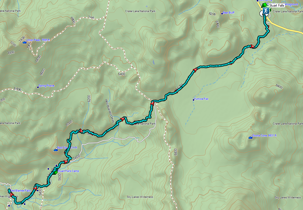
We spent a long weekend at Crater Lake National Park as we continue our quest to hike all 100 featured hikes in William L. Sullivan’s “100 Hikes/Travel Guide Southern Oregon & Northern California” (post). Our plans included the six remaining featured hikes in the Park that we had yet to hike, but before we got to those, we set our sights on a former featured hike. Stuart Falls had been a featured hike in Sullivan’s third edition but washouts in 2014/15 had severely impacted the western approach (April 2015 trip report by Van Marmot). The area was further damaged in the 2017 Blanket Creek Fire leaving the only viable approach to the falls from the East starting from the Pumice Flat Trailhead located at the Lodgepole Picnic Area.
It was a 4-hour drive from Salem so we arrived at the picnic area a little after 9am and set off on the Pumice Flat Trail.

The trail promptly crossed Highway 62 and then ran parallel to the highway for approximately a third of a mile before turning away (SW).
 Arriving at the highway.
 Trail on the far side of Hwy 62.
The Pumice Flat Trail climbed gradually for three miles through unburnt forest to the Pacific Crest Trail.


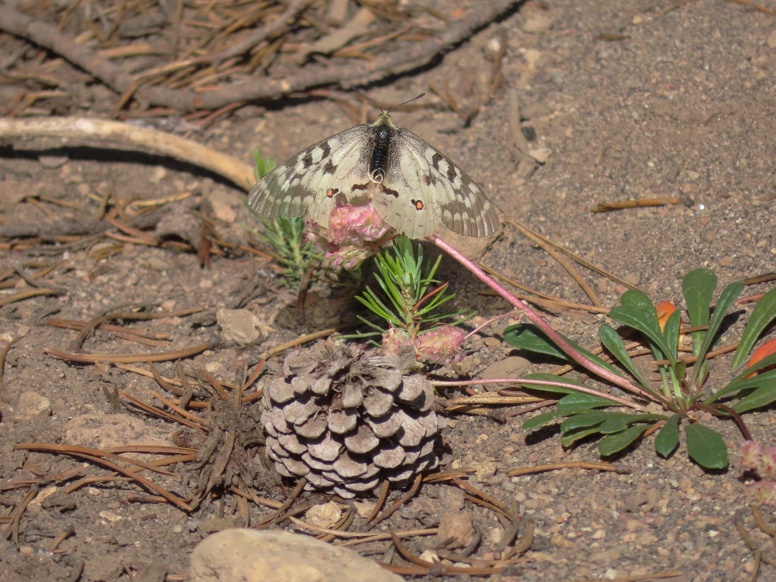 Clodius parnassian on a pussy paw.
 Much of the trail followed an old roadbed.

 PCT junction.
 Butterfly on the Crater Lake PCT register. While I was working on getting the butterfly photo a northbound thru hiker arrived. He mentioned not having had a shower in 10 days and being really excited to reach Mazama Village and being able to take one.
After a short conversation we turned right onto the PCT for 0.1-miles to the Stuart Falls Trail.


It took us just over three miles to reach Stuart Falls from the PCT. The extensive damage from the 2017 had left the trail hard to follow in some areas. It wasn’t clear how long it had been since the trail had been maintained but even where it was obvious there was plenty of blowdown to navigate.
 Older cut logs helped us locate the trail at times.
 Union Peak from the trail (post). (The “trail” is not in this photo.)

 It took a second to find the tread in this meadow.
 Once we found it though it was easy to follow.
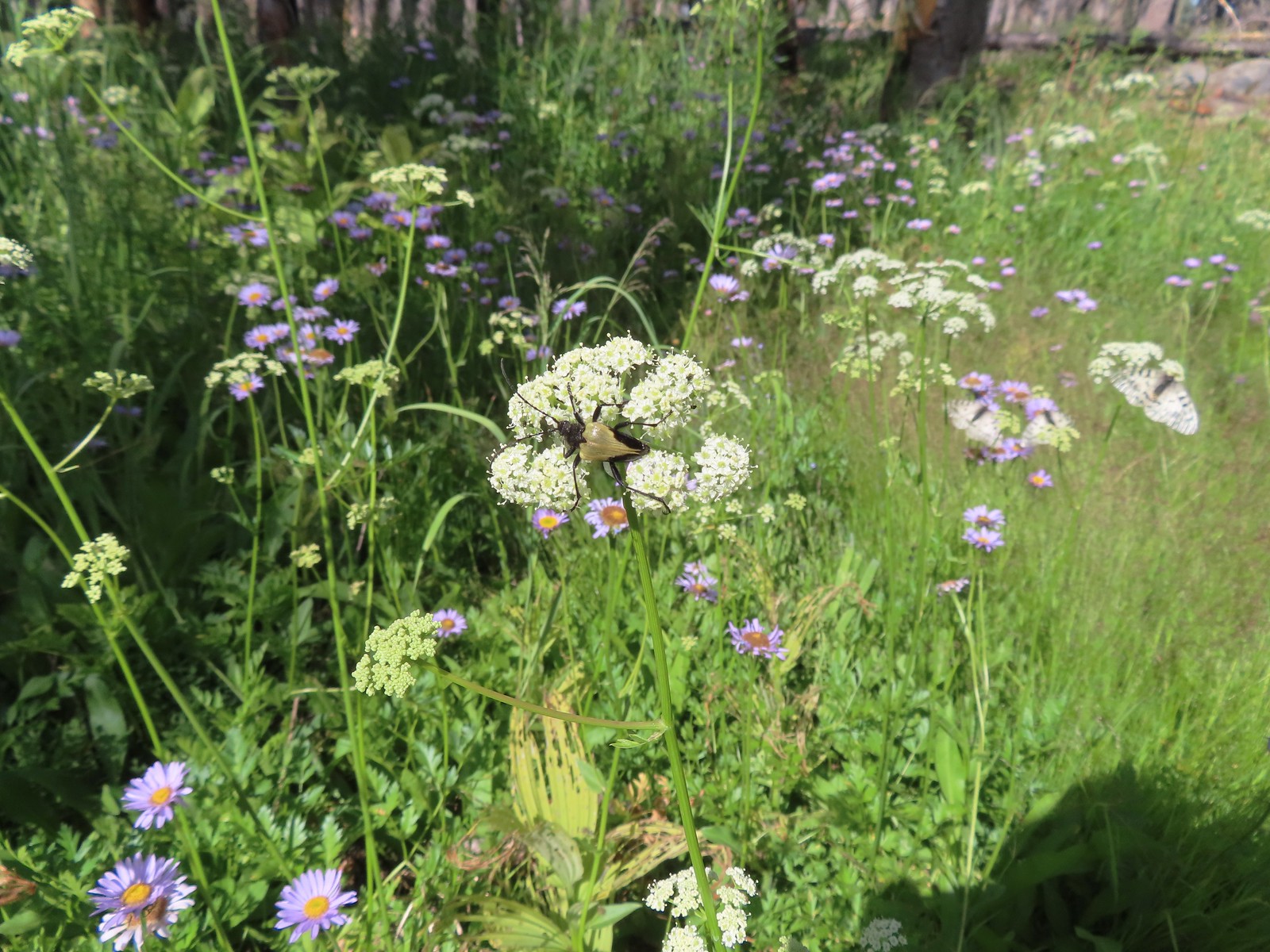 Big beetle. There are also three clodius parnassian butterflies behind to the right.
 Typical trail conditions. I spent a good deal of time removing limbs from the larger trees and pulled some of the smaller ones off the trail.
 Doe below the trail.
 More messy trail.
 There was one small stand of unburned forest which provided a brief break from the blowdown.
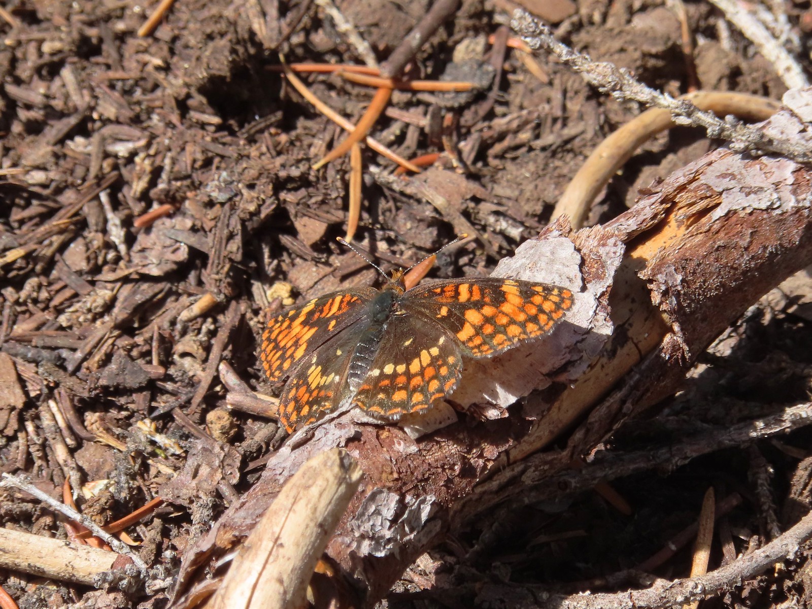 Checkerspot butterfly
 Mylitta crescent and a hoary comma on spreading dogbane.
 Paintbrush
 I believe that is Tom Mountain and Jerry Mountain.
 Bald Top to the right.
 Skipper

 Mt. McLoughlin
 Lorquin’s admiral
 This was the worst of the obstacles.
 We hadn’t seen a blue diamond since before the PCT but near the SW corner of the Park boundary we spotted a couple.
 Post ahead marking the boundary. The trail passed through a narrow gap here where the blowdown was heavy.

The trail left the Park and entered the Sky Lakes Wilderness.


We left the trail briefly to visit a viewpoint above Stuart Falls.

We continued downhill leaving the trail again to visit a large campsite near the base of 40′ Stuart Falls.


 Arnica below the falls and fireweed above the falls added some nice color to the scene.
 One-sided wintergreen
I had been toying with the idea of attempting to reach Red Blanket Falls which was another mile and a half from Stuart Falls. We discussed things while we took a break at the falls and I decided to go ahead and make the attempt despite the poor trail conditions while Heather would stay at Stuart Falls. We left it open that she would start back if she wanted and I would catch up after I turned around, whenever that wound up happening.
I struck off from Stuart Falls on some good tread that quickly disappeared.

Four tenths of a mile from the falls I arrived at a trail sign announcing that the old Red Blanket Trailhead was 4 miles away.

Another former trail forked left here that used to hook up to the Lucky Meadows Trail and eventually the PCT. I stayed right along Red Blanket Creek using it as an anchor point when I lost sight of the trail.


 Small falls on Red Blanket Creek.
 Pink monkeyflower
 I’d lost the trail here but headed for the patch of bright orange wildflowers to see what they were.
It wound up being a spectacular patch of leopard lilies.


A little further along I came across a small patch of Crater Lake Collomia.

A very tough mile from the first trail junction I arrived at a second signed former junction.

The next tenth of a mile was spent fighting through head high fireweed and feeling around on the ground to find footing in the thick vegetation that was hiding copious amounts of blowdown.

I was a bit bloody and bruised by I made it to Red Blanket Falls and was not disappointed.

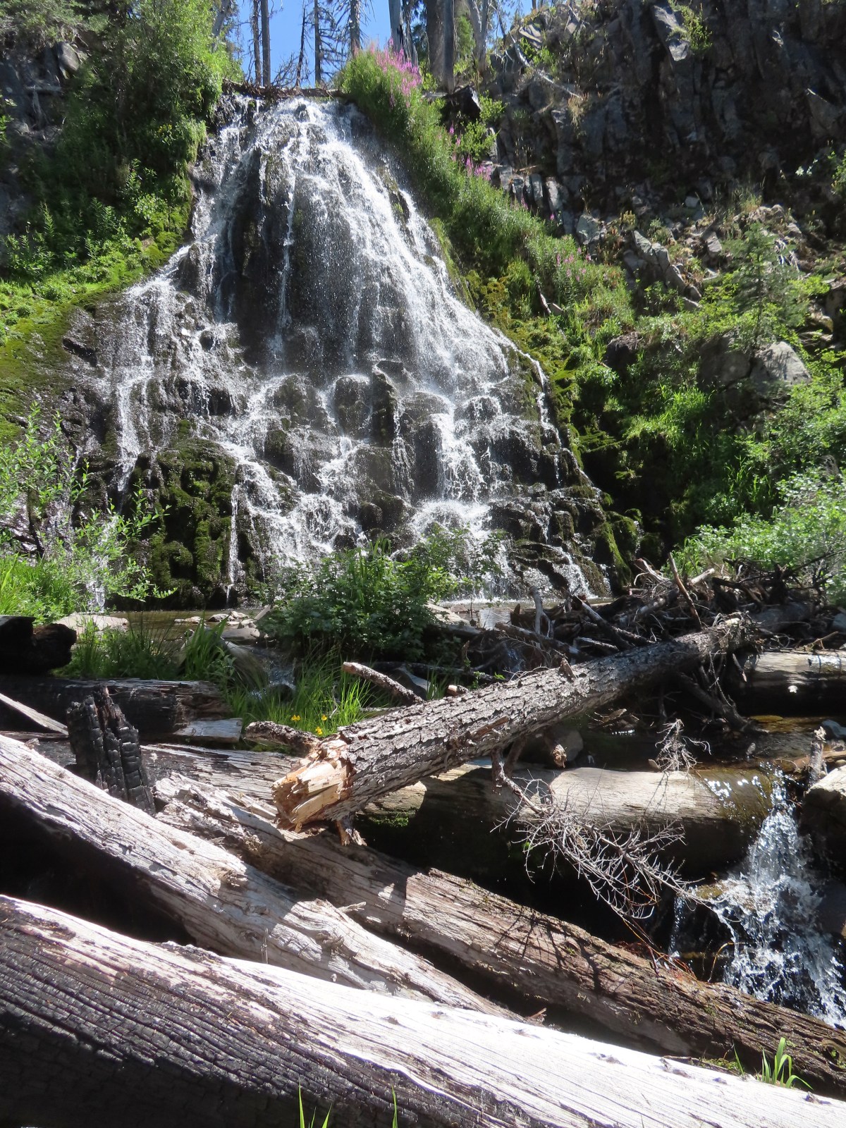
 Red Blanket Falls
 View down Red Blanket Creek
 A spring fed waterfall along Red Blanket Creek below the falls.
 A second and third tier of Red Blanket Falls just below the upper fall. I wasn’t able to get a clearer view of these two drops. I hiked a short distance down the creek but decided the poor trail conditions and loss of elevation weren’t worth going further down the trail with no guarantee of a better view.
 The three drops of Red Blanket Falls
 One more of Red Blanket Falls.
I headed back to Stuart Falls finding it a little easier to follow the old trail alignment going uphill. This resulted in some different views of the creek.
 Another little cascade.

In my excitement to reach Red Blanket Falls I had spent a little more energy than I had intended so when I got back to Stuart Falls I took a short break. Heather had started back but I needed to cool down, put on a fresh pair of socks, and have a snack.

After recovering a bit, I set off on my quest to catch up to Heather. Several times I found myself following tread that we hadn’t been on earlier.
 Along this rock outcrop I found switchbacks that I’d missed on the way to the falls.
 This might be a black backed woodpecker.
 This cairn was new to me as well. At this point I was quite a bit below our track from the morning and I was afraid that I might pass Heather without knowing it if she was sticking to the earlier route.
 Hummingbird
 Goose egg on the left.
I did wind up catching up with Heather who was also feeling fatigued from the tough trail conditions. We made our way back to the PCT where another brief break was had.

 Painted lady
 A checkerspot and a copper on sub-alpine fleabane.
 Arriving back at the PCT. We again crossed paths with a thru hiker on the way to Mazama Village.
It was nearly all downhill from the PCT but it was three more miles and we were both pretty beat. It was a bit of trudge back to the trailhead made worse by us both running out of water about a mile from the car. We had failed to make use of our filter and refill at Stuart Falls and we paid for it.

 Pussypaws
 Dwarf lupine
I tried hustling back to the car to retrieve a Gatorade and water to take back up the trail to Heather but she wasn’t far behind. I met her at the Highway with the drinks but it was the thought that counted.
My hike to Red Blanket Falls wound up being 15.9 miles (0.2 was due to taking the drinks back up the trail) and approximately 2000′ of cumulative elevation gain.
For an idea of what the hike was like prior to the fire here is a report by Van Marmot from July 2017.
It was nearly 5:30pm by the time we finished the hike. Luckily we were only about three miles from Mazama Village where we checked into our cabin then grabbed dinner at the Annie Creek Restaurant and some supplies from the small store where a number of PCT thru hikers were hanging out including the two gentlemen we’d seen on the trail. Aside from the two thru hikers the only other person we saw all day was a Park Ranger on the Pumice Flat Trail on our way back to the trailhead.
It was a lot longer and harder day than we’d planned for given we had three more days of hiking lined up, but I was happy that I’d made it to Red Blanket Falls. In the end it was worth the effort. Happy Trails!
Flickr: Stuart and Red Blanket Falls
