Categories
Hiking Middle Santiam Old Cascades Oregon Trip report

South Breitenbush Gorge Trail

**Note the 2020 Lionshead Fire burned the area covered by this hike.**

Well it seems that summer has arrived early in the Pacific NW. We’ve enjoyed some unusually warm/dry weather which has me making some adjustments to our hiking plans. We’re hoping that some of the trails will be snow free earlier this year than the previous couple. On the flip side we’re hoping that the weather doesn’t translate to an early or particularly bad fire season, but I digress. On to the trip report for the South Breitenbush Gorge trail.

For the second hike in a row we headed to the Detroit, OR recreation area, and for the 2nd week in a row we were greeted with great weather. This time we would be hiking the first 3.6 miles of the South Breitenbush Gorge trail. The trail itself continues on to Jefferson Park (one of my favorite places) where it meets the Pacific Crest Trail. The trail sets off near the South Breitenbush River and quickly crosses it on a series of footbridges. Our sources (William Sullivan’s “100 Hikes in the Central Oregon Cascades” and Oregonhiking.com) had warned that these bridges are prone to floods which was apparent upon seeing them. They were a patchwork of styles and materials which only added to their charm. This one in particular was rather bouncy which Dominique found a bit unsettling.
036

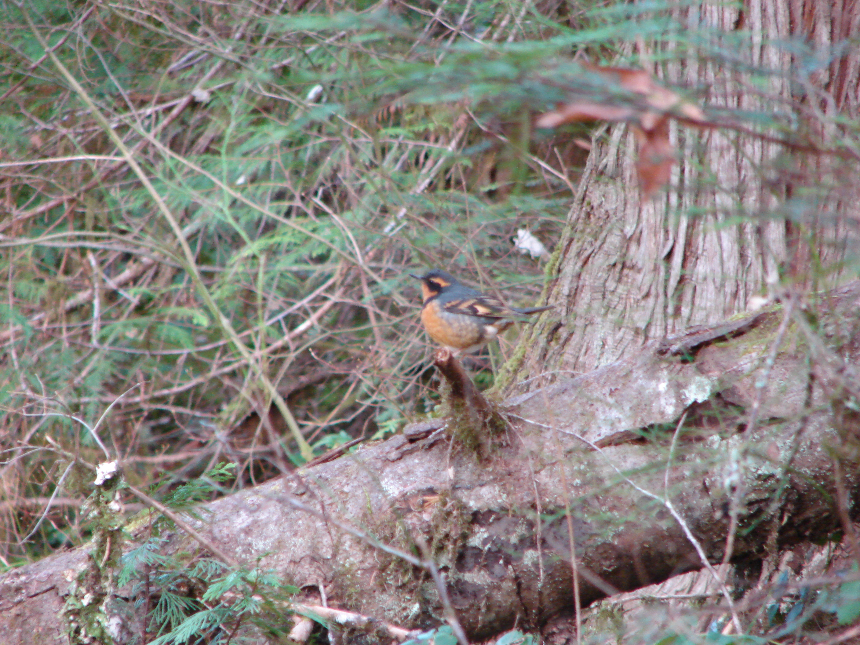
Once across the river the trail followed along at a distance through the forest. Never out of earshot but seldom in view the South Breitenbush flowed along on it’s way to Detroit Lake. In addition to the sound of the river there was almost always a bird singing, and though we didn’t see many we knew there was always one close by.

Like last week we spotted a flower that we had not previously seen on a hike. Last time it was Fairy Slippers (of which we saw many on this hike) and this time it was Fairy Bells which are twin small white flowers. In addition there were many other flowers in bloom including Wood Violets, Sourgrass, Red-Flowering Currant, Salmon Berries, Strawberries, Trillium, Vanilla Leaf, Oregon Grape, and Solomonseal. Rhododendron and Beargrass were present but had yet to bloom; although, there was a very colorful bud showing on a single Rhody and I managed to spot a Beargrass bloom along the road on the way back to Detroit. Heather is sure I am obsessed with Beargrass. She might be right.

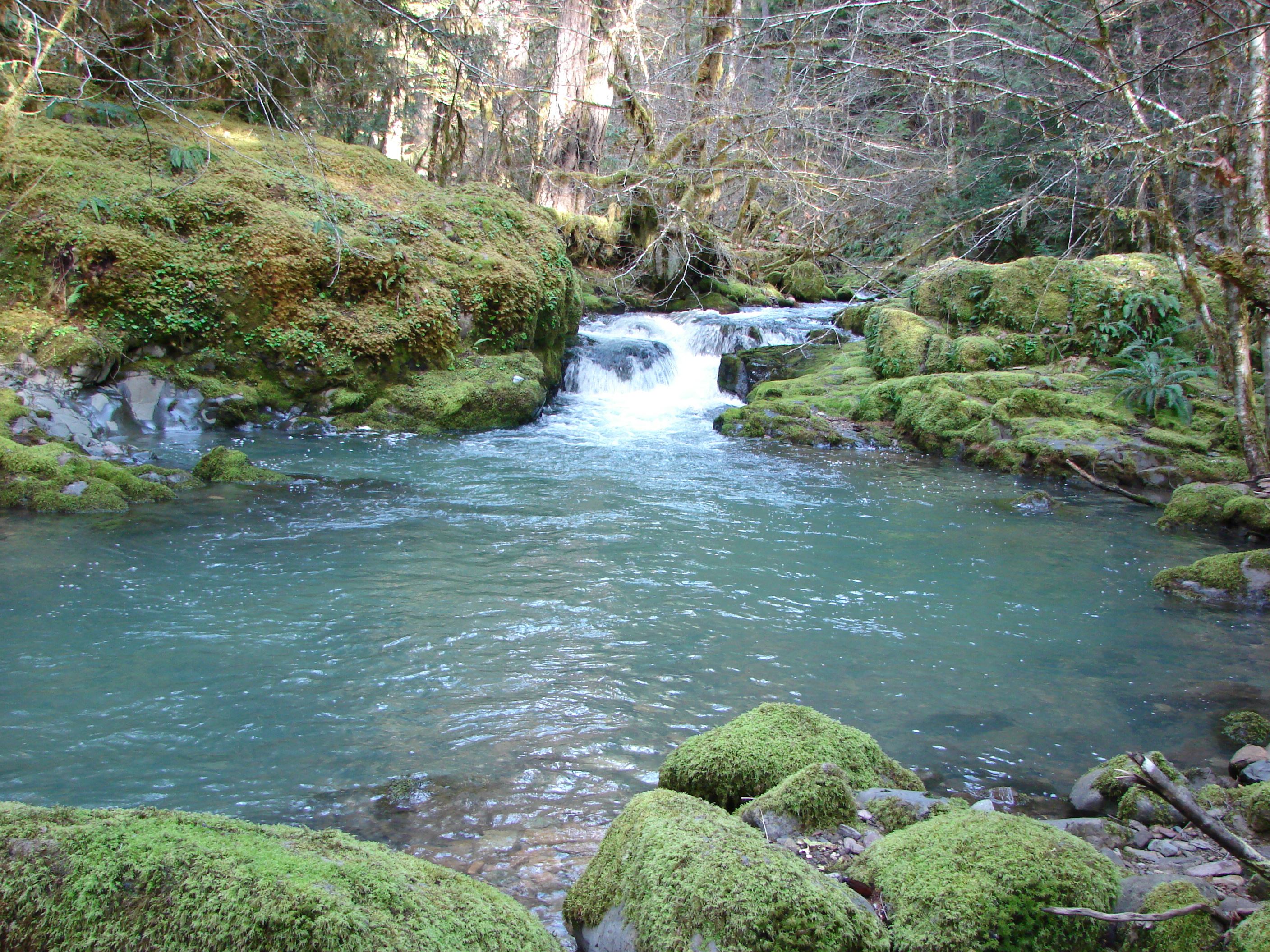
The trail was well maintained and never steep. Our goal was to reach Roaring Creek then continue another .5miles to a pullout on road 4685 that can be used as an alternate trail access. Roaring Creek was the scenic highlight. The water cascading over mossy rocks down through the forest was very pretty.
109

After spending some time taking in the view we continued on to our turnaround spot where we spotted a rough skinned newt and headed back to the car. This was our final planned hike with less than 1000 feet of elevation gain as we get ready to start climbing up to some better viewpoints. Something of which we are all looking forward to. Until next time – Happy Trails.

Facebook album: http://www.facebook.com/media/set/?set=a.10201152770168544.1073741829.1448521051&type=1
Flickr album: http://www.flickr.com/photos/9319235@N02/sets/72157633457445053/

Categories
Hiking Middle Santiam Old Cascades Oregon Trip report

Stahlman Point

**Note the 2020 Lionshead Fire burned a portion of this hike.**

Sometimes the weather makes you an offer you just can’t refuse. This was supposed to be an off weekend so Heather could rest after last weekends Eugene marathon, but the prospect of clear skies and 80 degree weather proved to be too enticing. We decided to sneak in a short hike to take advantage of the summer like conditions and chose Stahlman Point near Detroit Lake. We had started this hike a couple of times in years past but due to time constraints had never had made it to the summit viewpoint. The trail gains just over 1300 feet in 2.3 miles to the site of a former lookout tower.

The morning got off to a rocky start when I woke up 45 minutes after the alarm was to have gone off. Anyone familiar with the Sienfeld episode with the marathon runner should know it was the volume. Luckily we always get everything we can ready the night before a hike so after a bit of scrambling we were off at our normal time and were hiking by 6:30am.

There were several types of wildflowers in bloom including trillium, sourgrass, yellow wood violets, and our first encounter with fairyslippers.
053
It was still too early for the rhododendron and beargrass blooms but they were both starting to show buds and in a few weeks should be putting on quite a display. The trail offered a few glimpses of Detroit Lake and the ridges of the Willamette Forest beyond. A small spring trickles across the trail near the 2 mile mark. It then ends at a rocky viewpoint that was once home to a fire lookout. Here among the rocks were several other types of flower including a single penstemon that we nearly missed hiding at the base of an outcropping.

The viewpoint provided a clear view of Mt. Jefferson to the northeast. A lone cloud hovered over it’s summit and seemed to refuse to budge from it’s perch.
097
Several birds joined us while we had a quick snack and took in the view before heading back down to the car for our drive home.

Photos from the hike http://www.flickr.com/photos/9319235@N02/sets/72157633411223157/
http://www.facebook.com/media/set/?set=a.10201118887601501.1073741828.1448521051&type=3

Categories
Hiking Oakridge Area Old Cascades Trip report

Fall Creek

**Note a portion of this hike burned in the 2023 Bedrock Fire.**

We hope everyone had a happy Easter weekend. After attending a Saturday worship service we took advantage of some great weather and headed South to Fall Creek. This was our second hike in a row along a creek in the Willamette National Forest East of Eugene.

The forecast had been for a few showers throughout the day but lucky for us the weatherman was way off. Temps were in the low 50’s when we set off and it wound up being a warm and sunny day. The trail sets off on the Southern bank of Fall Creek through an old growth forest. The first few miles follow Fall Creek through this damp and mossy forest crossing several scenic side creeks on footbridges. This portion of the trail was fairly muddy in spots. Fall Creek was much larger than Larison Creek (our previous hike) with many deeper pools, and the clear water made for some great views. Our timing was good as many of the spring flowers were in bloom carpeting in the forest floor in yellow, purple, and white. The Trillium blooms were particularly pretty.
263

After 3.5 miles the old growth gives way to a section of forest that was burned in 2003. This burnt section housed many different wildflowers that prefer the direct sunlight afforded by the fire. It wasn’t long before that direct sunlight had us needing to remove some clothing layers. After a brief pit stop we were off again, now on the Northern side of the creek after crossing on a bridge.

Our goal had been Slick Creek Cave but we decided to continue another half a mile to Bedrock Campground just in case anyone wanted to use the facilities. When we first crossed Slick Creek we completely missed the side trail up to the cave despite my taking several pictures of the cliffs that housed it. When we reached the trail fork for the campground loop we realized we had missed it. The creek bed near the campground was very colorful and worth the extra distance.
215

We also came across a type of lily that we had not encountered before.
232

When we reached Slick Creek on our way back the side trail had magically appeared. We took the short obvious (this time) trail up to the cave which is basically a recess in the cliff. Apparently it was used by Native Americans for shelter at one point and made for a nice side trip.

Overall this turned out to be a really nice hike. In addition to the various wildflowers we saw a decent amount of wildlife. In the old growth section we came across several snails, slugs, birds, and a Rough Skinned Newt. The burnt section offered geese, ducks, an osprey, several lizards, and a snake. Although this is a heavy use trail we only ran into a handful of people on the trail on this day. Due to the various campgrounds along Big Fall Creek Road which follows the creek on the opposite side there was some car traffic and a number of campers across the water.

As usual I took way too many pictures which can be viewed in full on Flickr http://www.flickr.com/photos/9319235@N02/sets/72157633132796203/
or in condensed version on Facebook http://www.facebook.com/media/set/?set=a.10200914954943312.1073741826.1448521051&type=3

Categories
Hiking Oakridge Area Old Cascades Oregon Trip report

Larison Creek

It’s been a few weeks since our last hike. We usually do several races between February and May and the training for those leaves us a little less time for hiking. Really it is nice to have the running because a lot of the trails are still snowed under and the weather isn’t always conducive to hiking. We are trying to fit a hike in every few weeks though to get prepared for our peak hiking season. Our most recent hike was up Larison Creek which is just East of Oakridge, OR. Larison Creek

We had not done any hiking near Eugene or along Hwy 58 yet and were looking forward to exploring a new area. The weather cooperated and we had a dry and mostly sunny day. It was a chilly 31 degrees when we set out, but (Aside from some chilly fingers which was our fault for not bringing the proper gloves.) it didn’t seem that cold. The hike starts next to Larison Cove which is a milky green color. This is partly due to Blue-Green Algae.

The trail slowly climbs along the creek through a moss covered forest. At times the forest floor seemed as if a layer of green snow had fallen covering everything. Small Snow Queen flowers bloomed along the first portion of the trail adding a splash of purple to the greens and browns. Larison Creek flowed within earshot, and was often in view. A couple of short paths led to clear pools below small slides or chutes that were worth the slight detour. As we gained elevation beargrass and rhododendrons became more common, but it was too early for them to be in bloom. We eventually ran into some patches of snow displaying the transition from Winter to Spring.

Wildlife was limited to birds, most notably the first Varied Thrush we had seen. Despite his posing for some pictures I was able to get a very clear shot as you can see here. Varied Thrush

Facebook album (selected photos) http://www.facebook.com/media/set/?set=a.10200791264571130.1073741825.1448521051&type=3

Flickr album (all photos) http://www.flickr.com/photos/9319235@N02/sets/72157632972427272/