
Continuing on our quest to hike at least part of all 100 featured hikes in William L. Sullivan’s “100 Hikes Eastern Oregon” 1st edition (2022) we followed up our hike to Chimney Lake (post) by returning to Lostine River Road for the second day and parking at the Maxwell Lake Trailhead.

Today’s hike was approximately 2.5-miles shorter than the hike to Chimney Lake but gained the same 2420′ of elevation.
Like the previous days hike we crossed Lostine River Road from the trailhead and then crossed the Lostine River on a bridge.

 The trail passes through the Shady Campground.

 Lostine River
On the far side the bride the trail entered the Eagle Cap Wilderness.

Our plan for this hike was to split up to make the climb at our own pace and then I would wait for Heather at the lake, or until 11am in the event that she decided not to go the entire way. After entering the wilderness the trail initially climbed at a steady pace via 7 long switchbacks.
 Unnamed creek crossing.


 Thimbleberry
 One of the switchbacks.
 Climbing into the sunlight.
 Possibly a Cassin’s vireo.

 Another switchback.
 Fireweed
 Monkshood
 Twisted stalk
 Eagle Cap (post)
 Looking down from the trail.
 Paintbrush
 Chipmunk
Shortly after the seventh switchback the trail turned uphill and began a very steep 0.8-mile climb to a pass.
 The trail turning uphill ahead to start the steep climb.
Given this was our fifth day in a row of hiking, and fourth significant one, this steep section was a killer. My legs were burning as I made my way up to the pass.

 Meadow along a brief section of reasonably graded trail.
 Nuttal’s linanthus


 The pass in view.

 Twin Peaks to the left over the shoulder of the ridge.
From the pass it was 0.2-miles down to Maxwell Lake.
 The trail down to Maxwell Lake.
 Ground squirrel on alert.
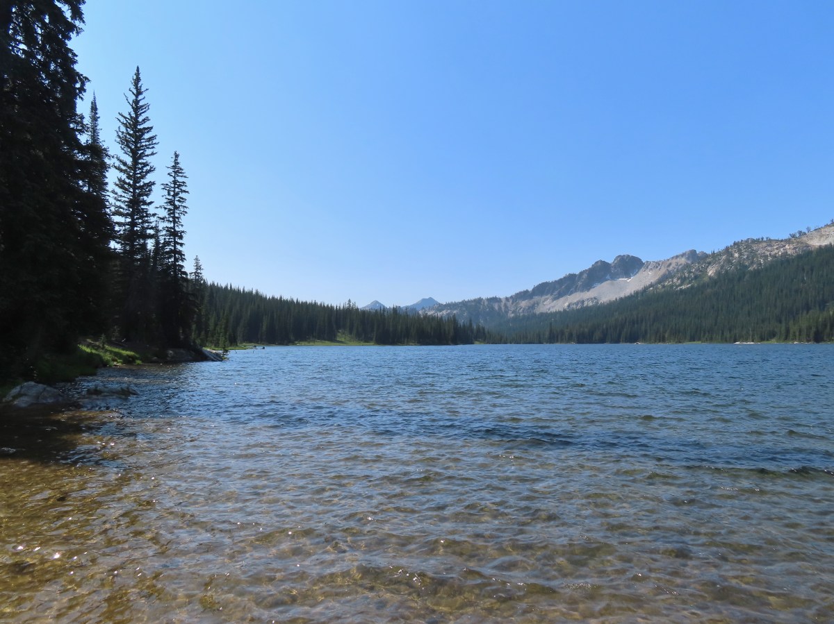
 Maxwell Lake
The lake was gorgeous. I explored the shoreline for a moment before climbing up a granite outcrop with a great view of the lake and the trail coming down from the pass. I figured that Heather might be able to see me when she arrived and/or I’d notice her on her way down.


 Aster along the outlet creek.
 Gentians

 Island in Maxwell Lake.

 The view from the granite outcrop.

 Looking back at the pass from the outcrop.

 Last of the snow at Maxwell Lake.

I relaxed for about an hour at this beautiful lake before I spotted Heather coming down from the pass. It was chilly enough that I wound up eventually pulling out my wind jacket which was a wonderful change from our last couple of trips to the Wallowas. She made her way to the outcrop and joined me there. After she’d had a chance to rest we did a little more exploring and followed a use trail to nearby Jackson Lake.
 Trail along Maxwell Lake.

 Trail to Jackson Lake.
 Jackson Lake
 False hellebore
 Pika raising a warning call. Interestingly the pikas in the Wallowas make a sound that we don’t recall hearing from pikas in other areas. It was almost as if they had their own regional dialect.
After checking out Jackson Lake we started back.
 Passing back over the granite outcrop.
 Maxwell Lake’s outlet creek.
 Trout in the outlet stream.
 One last look at Maxwell Lake.
 The view from the pass on the way back.
 Heading down the steep section.
Aside from the lookout staffer at Summit Point and a couple of backpackers on the far side of Chimney Lake we hadn’t seen anyone else on the Wallowa trails until heading back down to the Maxwell Lake Trailhead. The first person we passed was coming up the steep section. She obviously spent quite a bit of time hiking in the area and was showing no signs of struggling with the steepness of the climb. We stopped and chatted for a bit and we told her about our featured hike quest. When we mentioned that the last hike on our list was Hidden Lake and we were planning on doing it as an overnight backpack she relayed some very helpful information regarding possible campsites. We thanked her and continued downhill running into a couple a little further down that were finding the climb as challenging as we had. We passed several more hikers on the way down, some with backpacking gear and some with fishing rods. We were glad to have had the lake to ourselves while we were there.
 The afternoon lighting on the ridge across the Lostine River really brought out the colors.
 Eagle Cap way up the valley.
 Heather counted at least seven significant drops on a creek cascading down the far hillside.
 Fritillary

 Canada jay
 Police car moth
 Back at the bridge over the Lostine River.
 Lostine River
 The Maxwell Lake Trailhead in the afternoon.
My GPS read 8.6-miles for the hike to Maxwell and Jackson Lakes with a little over 2400′ of elevation gain.

We returned to Enterprise and after cleaning up headed out for an early dinner at La Laguna. The food was good, and their hand made Lagunita’s Salsa Loco had a nice kick to it. We took a slice of blackberry cheesecake to go which was also quite tasty. The next day would be our last hike for this trip and would put us at 99/100 featured hikes from Sullivan’s Eastern Oregon book and 499/500 for all five of the regions he covers. Happy Trails!
Flickr: Maxwell Lake


 The trail entered the

 Lewis monkeyflower
 Eagle Cap (
 Chipmunk
 One of the switchbacks.
 Western tanager
 Pearly everlasting
 Paintbrush
 Baneberry
 Pika
Pika
 Bowman Creek
 Grass of parnassus
 The trail crossing Bowman Creek.
 Arnica
 Monkeyflower
 Bees on American sawort.


 Golden-mantled ground squirrel
 Another pika.
 Elderberry
 The lefthand fork led to a campsite and meadows in the basin.
 Gentians
 Meadow in Brownie Basin.
 The junction with the Chimney-Wood Trail.

 One of several pine siskins that were in these plants.
 Aster
Aster
 Fritillary
 Lupine and aster
 Butterfly on pearly everlasting

 Another western tanager.
 Gentians and St. Johnswort
 Lower Laverty Lake
 A patch of fireweed above the lake.
 Hooded ladies’-tresses
 American kestral
 Lower Laverty Lake
 Twin Peaks across the Lostine River valley.
 Eagle Cap at the far end of the valley.
 Heading for Chimney Lake.
 Chimney Lake
 Gentians along the lakeshore.
 The rocks ahead where we took our break.
 Islands in Chimney Lake.
 No matter how cute they are, please don’t feed the wildlife (
 Sulphur butterfly
 We heard more pikas than we saw. Here is the one, blurry, photo I managed to get.
 Milbert’s tortoiseshell
 Golden-mantle managing to feed itself.
 Twin Peaks
 Aster
Aster
 California tortoiseshell
 Grouse
 A comma, possible green comma.
 Back at the bridge over the Lostine River.
 Lostine River in the afternoon.

 Even at 6am on a Thursday the trailhead parking was nearly full.
 This was a neat feature.
 We both counted our steps, for me it was 50 and Heather 60.
 The Lostine River.
 Entering the Eagle Cap Wilderness just before the trails split.
 Trail sign at the fork.
 Bridge over the East Fork Lostine River.
 East Fork Lostine River
 The storm overnight had provided a little much needed rain.
 Huckleberries (I’d already picked the ripe ones.)

 Elkhorn Peak
 Monkshood

 Some of the river channels were very calm and crystal clear.
 We passed through a section of bent and snapped trees which were probably a result of an avalanche.

 Glacier Mountain
 Looking back at the other side of Elkhorn Peak.
 Nuttal’s linanthus
 Looking back down one of the steeper sections. We passed another couple heading out along this section.
 Looking up the Copper Creek drainage. Glacier Mountain on the left and Elkhorn Peak on the right.
 Off-trail waterfall. We could hear this from the trail, and it was a fairly easy bushwack to get a good view.
 The river crossing.

 Yellow columbine
 A little hazy looking toward the Sun.

 Elephants head
 Unnamed creek
 An easier crossing of the river here.


 First view of Minam Lake.
 Minam Lake
 Common mergansers
 Needle Point is the peak in the distance to the far left.
 Shooting stars
 We could have stared at the rocks along the ridges for hours.
 Heading back.
 Violet
 Groundsquirrel
 Robin
Robin Fritillary
 Orange agoseris
 The fire was burning up in that basin somewhere.
 The talus section in the afternoon.
 Spirea

 Butterflies and moths were out in force.
 Police car moth and another interesting looking pollinator (out of focus).

 Prince’s pine
 Back at the junction with the East Fork Lostine River Trail.
 Left for hikers and right for stock.
