
2024 was a big year for us hiking wise. It wasn’t the number of hikes (55 days on trail) or mileage (496.8), but the culmination of an eight-year goal to complete all 100 hikes from a single edition of William L. Sullivan’s five regional guidebooks (post).
With our focus set on finishing the Eastern Oregon book, and in the process the 500 hikes, we primarily stuck to Oregon this year. In order to complete that goal we took three separate trips to NE Oregon and one to Central Oregon. We did spend three days hiking in Washington but failed to make it to California or Idaho this year. We also only spent four days hiking in Southern Oregon in 2024.

Our easternmost hike was at Hat Point, Oregon above Hells Canyon (post).

Our southernmost hike was an overnight trip in the Sky Lakes Wilderness (post).

As always seems to be the case our westernmost hike involved the Pacific Ocean, this time at Crescent Beach (post).

Finally, our northernmost hike was during the same day as our westernmost hike. After visiting Crescent Beach we drove north to Oregon’s Fort Stevens State Park for a hike which was further north than any of the hikes we did in Washington this year.

As mentioned above there were 55 days spent hiking which included a total of 84 stops. Twenty of the stops involved trails that we’d hiked before but none of these were exact repeats. Out of the 496.8 miles 75.4 were repeated from previous years.
One unique aspect to this year was relying on different forms of transportation for two of the hikes.
 In July we took the Wallowa Lake Tramway up Mount Howard (post).
 In August we traveled by boat to Wizard Island in Crater Lake National Park (post).
We were fortunate to have good weather for most of the year. It got damp at the end of October and stayed that way for most of the remainder of the year, but our November vacation took us to Disneyland (post) where the weather was close to perfect. That was our first non-hiking (albeit a lot of walking) vacation since 2012.

While weather wasn’t an issue, wildfires were. In particular smoke from a record setting 1,937,512 burned acres beginning with the Little Yamsay Fire in April. The fires really took off in July and the fire season wasn’t officially declared over until October 28th.
 The Town Gulch Fire near Carson, OR was dangerously close to blocking our access to one of the featured hikes we needed to do to finish our goal (post).
Here are a some of our favorite sights from the previous year.
 January – Corvallis to Sea Trail
 February – Sunrise from Maple Creek Road
 March – Mary’s Peak from Fitton Green
 April – Bridal Veil Falls
 May – Fishhawk Falls
 May – Willow Creek Trail
 May – Juniper Hills Preserve (The trails here were/are closed so we simply parked along the road and took pictures.)
 May – Madison Butte
 June – Cook Hill
 June – Deception Butte Trail
 June – Mt. Adams from Big Huckleberry Mountain
 June – Grasshopper Meadow (Unfortunately this area burned by the Young Grasshopper Fire in September.)
 July – Horsepasture Mountain
 July – Nasty Rock Trail
 July – Lower Bonny Lake
 July – Minam Lake
 July – Mount Howard
 August – The Pinnacles
 August – Downing Creek Falls
 August – Schneider Cabin
 August – Pine Lakes Trail
 August – Laverty Lake
 August – Aneroid Lake
 September – Hidden Lake
 September – Mt. Jefferson from Sprague Lake
 September – Black Wolf Meadows
 October – White River Canyon
 October – Kinzel Lake
 October – Sawtooth Trail
 October – William L. Finely National Wildlife Refuge
 October – Gold Lake Shelter
 November – Silver Falls State Park
 December – McKenzie River Trail
We couldn’t have asked for much more out of this year’s hikes and for the first time in eight years we don’t have any specific hiking goals that we are working on. Our focus will remain on visiting trails that we still haven’t hiked as well as expanding the areas we’ve visited. Happy Trails!


 The tramway from the top.
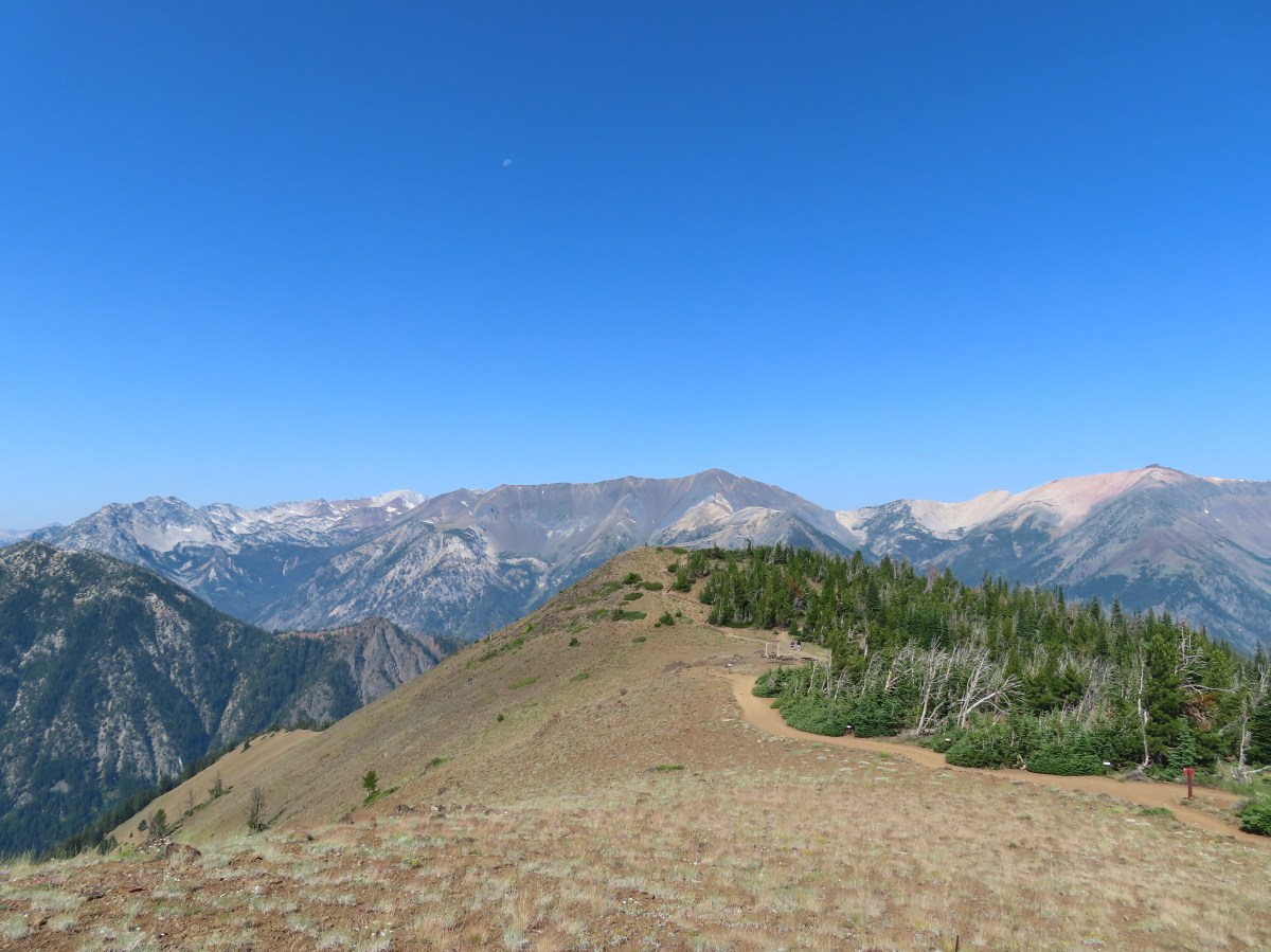
 Pointer for the Royal Purple Overlook (right) and Summit Overlook (left).
 Penstemon
 Heading out to the Royal Purple Overlook.
 They do hold weddings up on the mountain.
 Lewis flax
 Mountain coyote mint
 The Hurwal Divide, Point Joseph and Ruby Peak from left to right.
 Pete’s Point, West Aneroid Peak, Eagle Cap the furthest away (
 Closer look at Eagle Cap.
 Craig Mountain and the Matterhorn (
 East Peak
 Pano that Heather took with her phone.
 Buckwheat
 Pointer for the Summit Overlook.
 View from the Summit Overlook. Heather is standing on the Royal Purple Overlook.
 Buek’s groundsel
 Point Joseph
 East Peak as I neared the Summit Overlook.
 The Seven Devils poking up above the smoke from Idaho.
 Seven Devils
 Mount Melissa to the left and East Peak straight ahead.
 The 4-way junction.
 East Peak from the 4-way junction.

 Mountain bluebird
 Climbing to the saddle.
 The view from the saddle.
 Wood blocking the lower end of the “short-cut”.
 Looking back at the Summit Overlook during one of my several breaks during the climb up.
 There were a few obstacles to avoid along the climb as well.
 The Royal Purple Overlook from the trail.
 Up, up I go.
 Golden-mantled ground squirrel watching me navigate some blowdown.
 The views helped keep my mind off the climbing.
 The second saddle in sight.
 The angle was enough different from the saddle that I could see a couple of additional peaks.
 The Matterhorn on the left and now Sacajawea Peak behind the Hurwal Divide to the Matterhorns right.
 The saddle provided a brief level stretch before the trail launched steeply uphill again.

 East Peak
 Lots of buckwheat along this section.
 Buckwheat and lupine above the trail.
 The fork. According to Sullivan the righthand fork peters out in about 0.2-miles and then it’s possible to scramble up East Peak in another three quarters of a mile. I went left heading for the spring.
 The McCully Creek Trail which we hiked a couple of days earlier (
 A phacelia
 Lyall’s Goldenweed
 Wallflower
 Looking back at the trail.
 Flowers near the springs.
 Shrubby cinquefoil surrounded by bistort and mountain death-camas.
 Mountain death-camas and bistort
 Looking up at the springs.
 Monkeyflower
 There were several smaller streams below East Peak.
 Aneroid Mountain
 Ground squirrel
 View from my turn around point.
 Looking back at my route to the second saddle.

 Dusty maidens near the springs.
 Heading down to the saddle.
 Cairn at the saddle.
 Milbert’s tortoiseshell
 Pale agoseris
 Climbing back up to the 4-way junction.
 Back on the Summit Loop.
 Crossing the service road coming up from McCully Creek.
 Mountain Heather
 Pointer for the Valley Overlook.
 Spur trail to the Valley Overlook.
 Flag at the Valley Overlook.
 Wallowa Lake below the Valley Overlook.
 Wallowa Lake
 East Peak peaking up over the trees.

 Wallowa Paintbrush
 The upper terminal.
 Apparently Heather was busy making a friend while I was visiting the springs even though she did not feed any animals.
 The straight line is the tram ride.
