Part two of 2025 wildlife wrap-up is a collection of the non-bird critters that we were able to get a photo of during our 2025 outings. I checked one animal off the list of those that we hadn’t seen while hiking during our Tygh Creek hike in May when I spotted a skunk making its way up the trail ahead. Heather unfortunately missed out on that sighting. We also saw a sea otter during our visit to Olympic National Park in May however it was so far away that we weren’t sure what we were looking at until we were able to look at the couple of photos that I had taken. It was exciting to have seen one, but it would have been more exciting had we realized what we were seeing at the time. The other exciting (and scariest) sighting was just our second rattlesnake in the Criterion Tract along the Deschutes River, also in May. We didn’t see it until we heard the loud hiss and rattle letting us know that we were getting too close.

Bumble bee – Mt. Hood National Forest, 05/24/25.

Bee swarm – William L. Finley National Wildlife Refuge, 04/30/25.

Unknown bee species – Criterion Tract, 05/25/25.

Beetle – Criterion Tract, 05/25/25.

Beetle – Criterion Tract, 05/25/25.

Beetles – Mt. Jefferson Wilderness, 07/14/25.

Beetles – Mt. Hood National Forest, 06/14/25.

Isopod – Olympic National Park, 05/15/25.

Western sea slater (Ligia occidentalis) – Olympic National Park, 05/14/25.

Spider hiding in the camas – Thurston Hills, 04/19/25.

Crab spider – Clearwater River Trail, 06/21/25.

Slug – Thurston Hills, 04/19/25.

Slug – Fern Ridge Wildlife Area, 05/03/25.

Slug – Olympic National Park, 05/13/25.

Slug – Olympic National Park, 05/12/25.

Slug – Olympic National Park, 05/15/25.

Snail – Oswald West State Park, 04/05/25.

Snail – Loon Lake Recreation Area, 05/03/25.

Snail – Fern Ridge Wildlife Area, 05/03/25.

Snail – Umpqua National Forest, 05/31/25.

Dragon flies – Mt. Washington Wilderness, 07/19/25.

Caterpillar – Olympic National Park, 05/13/25.

Caterpillars – Mt. Jefferson Wilderness, 07/17/25.

Cinnabar moth – Mt. Jefferson Wilderness, Linn County Oregon, 07/17/25.

Plume moth – Mt. Jefferson Wilderness, Linn County Oregon, 07/17/25.

Moth – Mt. Jefferson Wilderness, Marion County Oregon, 07/14/25.

Moth – Mt. Washington Wilderness, Linn County Oregon, 07/19/25.

Moth – Mt. Hood National Forest, Wasco County Oregon, 06/14/25.

Brown elfin (and fly) – Mt. Hood National Forest, Wasco County Oregon, 05/24/25.

Ochre ringlet – Criterion Tract, Wasco County Oregon, 05/25/25.

Cabbage White – Tualatin River National Wildlife Refuge, Washington County Oregon, 05/01/25.

Margined white – Oswald West State Park, Tillamook County Oregon, 04/05/25.

Western white? – Mt. Hood National Forest, Hood River County Oregon, 07/12/25.

California tortoiseshell – Mt. Hood National Forest, Hood River County Oregon, 07/12/25.

Sagebrush checkerspot (f) – Criterion Tract, Wasco County Oregon, 05/25/25.

Sagebrush checkerspot? (m) – Criterion Tract, Wasco County Oregon, 05/25/25.

Checkerspot (Hoffman’s?) – Mt. Hood National Forest, Hood River County Oregon, 07/12/25.

Clodius Parnassian – Sourgrass Mountain, Lane County Oregon, 06/28/25.

Propertius duskywing – Mt. Hood National Forest, Wasco County Oregon, 06/14/25.

Possibly a Pacuvius Duskywing (Erynnis pacuvius) – Mt. Hood National Forest, Wasco County Oregon, 05/24/25.

A skipper – Criterion Tract, Wasco County Oregon, 05/25/25.

Field crescent – Mt. Washington Wilderness, Linn County Oregon, 07/19/25.

Meadow fritillary – Mt. Rainier National Park, Yakima County Washington, 08/08/25.

A fritillary but not sure which one. – Criterion Tract, Wasco County Oregon, 05/25/25.

Another of the fritillaries. – Mt. Jefferson Wilderness, Linn County Oregon, 07/17/25.

Wester sulphur – Mt. Hood National Forest, Wasco County Oregon, 06/14/25.

Indra swallowtail – Criterion Tract, Wasco County Oregon, 05/25/25.

Pale tiger swallowtail – Mt. Hood National Forest, Wasco County Oregon, 06/14/25.
When it comes to the Lycaenidae Family (Gossamer Wings) I am almost always out of my depth trying to identify them.
Mt. Jefferson Wilderness, Marion County Oregon, 07/14/25.

Mt. Hood National Forest, Wasco County Oregon, 05/24/25.

Mt. Washington Wilderness, Linn County Oregon, 07/19/25.

Criterion Tract, Wasco County Oregon, 05/25/25.

Olympic National Park, Clallam County Washington, 05/13/25.

These might be Echo Azures – Mt. Hood National Forest, Wasco County Oregon, 05/24/25.

Crab – Olympic National Park, Clallam County Wasing 05/14/25.

Hermit Crab – Olympic National Park, 05/14/25.

Velalla velella – Olympic National Park, 05/14/25.

Anemones – Olympic National Park, 05/14/25.

Starfish – Olympic National Park, 05/14/25.

Lions mane jellyfish – Rockaway Beach, 09/06/25.

Sealion – Olympic National Park, 05/14/25.

Seals – Olympic National Park, 05/15/25.

Sea otter, albeit a poor picture – Olympic National Park, 05/14/25.

Tree frog – Mt. Washington Wilderness, 07/19/25.

Frog – Mt. Jefferson Wilderness, 07/14/25.

Bullfrog (invasive) – Ankeny National Wildlife Refuge, 04/28/25.

Painted and western pond turtles – William L. Finley National Wildlife Refuge, 04/30/25.

Dunn’s salamander – Thurston Hills, 04/19/25.

Rough skinned newt – Driftwood Beach, 01/11/25.

Lizard – Mt. Hood National Forest, 05/24/25.

Snake – Ankeny National Wildlife Refuge, 04/28/25.

Snake – McDonald-Dunn Forest, 07/05/25.

Western racer – Mt. Hood National Forest, 05/24/25.

Western rattlesnake – Criterion Tract, 05/25/25.

Olympic chipmunk – Olympic National Park, 05/13/25.

Townsend’s? chipmunk – Silver Falls State Park, 10/13/25.

Yellow pine chipmunk – Mt. Rainier National Park, 08/04/25.

Golden-mantled ground squirrel – Mt. Rainier National Park, 08/04/25.

Douglas’ squirrel – Olympic National Park, 05/13/25.

Western gray squirrel – William L. Finely National Wildlife Refuge, 04/30/25.

California ground squirrel – E. E. Wilson Wildlife Area, 04/27/25.

Nutria (invasive) – Tualatin River National Wildlife Refuge, 05/01/25.

Yellow-bellied marmot – Three Sisters Wilderness, 07/15/25.

Hoary marmot – Mt. Rainier National Park, 08/05/25.

Pika – Mt. Jefferson Wilderness, 07/14/25.

Rabbit – Ankeny National Wildlife Refuge, 04/28/25.

Racoon – Olympic National Park, 05/14/25.

Skunk – Mt. Hood National Forest, 05/26/25.

Coyote – William L. Finley National Wildlife Refuge, 04/30/25.

Black-tailed deer – Mt. Rainier National Park, 08/04/25.

Mule deer – Criterion Tract, 05/25/25.

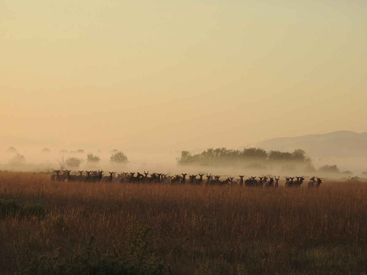
Elk – Elk Run Trail, 10/11/25.

Mountain goats – Mt. Rainier National Park, 08/05/25.
Being fortunate enough to witness animals in their natural habitat is one of the perks of hiking and we hope to see many more this coming year. We’re still on the lookout for several species that are possibilities. Most notable and likely of these are porcupines, giant pacific salamanders, and cougars. Much less likely but possible are wolves, wolverines, and moose among others. Happy Trails!


 \
\


 Fireweed


