
I visited Bob and Crystal Riley Park for the first time on my previous outing. On that visit I hiked the 3.5-mile Parrett Mountain East Loop (post) described in the Oregon Hikers Field Guide. I had really enjoyed that hike and knew I wanted to return at some point to try the slightly longer West Loop that is also described in the Field Guide.
I hadn’t planned on that visit being my next hike, but after looking over nearby options for hikes in the 4 to 4.5-mile range the Parrett Mountain West Loop was the one that I hadn’t previously done. It also gave me the opportunity to introduce Heather to the park.
Like my previous hike we began the West Loop from the Farmhouse Trailhead.

For the West Loop we crossed Parrett Mountain Road and passed through an opening along a fence to pick up Curtis’ Field Loop (trail #5).

The opening next to the sign across Parrett Mountain Road.
We turned left next to a field of crimson clover and followed the wide track next to Parrett Mountain Road.


Coastal manroot and crimson clover

Robin. Just like my experience on my previous visit we could hear birds almost constantly throughout our hike.
At the end of the field, we left trail 5 and stayed straight along the fence following trail 6 aka Bobcat Loop on the 2026 park trail map.


Rabbit
The trail turned right along a fence line at a vineyard and entered a nice forest.

The trail quickly split with trail 7 Forrest’s Loop on the left and trail 6 heading right. We stayed left along the fenceline.


Thimbleberry

Columbine

Inside-out flower
At the next fork we stayed right. A narrow connector path on the left dropped steeply along the fence line before rising just as steeply to rejoin the official Forrest’s Loop which avoided this drop and climb.

After the connector trail rejoined the Forrest’s Loop this trail made its own steep climb. We stayed left at junctions as we followed the fence line to a 90-degree turn. The trail steepened again here as it continued along the fence.


Rose

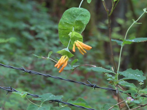
Honeysuckle


Starflower


Plumed solomonseal


Coming up on another junction with trail 6 (Bobcat Loop).

There are some older signs with trail names on this side of the park. One thing to note is that trail 6 which is named the Bobcat Loop on the park map is signed as Ed Casey’s Way on the signs.
Forrest’s Loop arrived at a junction near another field with Bert’s Field Loop (trail #9) where we turned left.

We stayed along the edge of this field until we came to a sign for “Bert’s 80 Field Loop” on our left next to a narrow trail heading into the forest.

The old wooden sign in the distance.

This path, Donald T. Everest Family Heritage Trail (shown as a part of the Bert’s Field Loop trails on the current map) began by dropping through a nice forest full of sword ferns and Oregon grape before coming to a more open grassy section where things got interesting.


There had been some occasional poison oak along the trails so far, but the amount increased drastically in the more open section. On the plus side we did come across a group of blooming ookow.

Head high poison oak on both the left and right.

Ookow with poison oak behind.

More ookow and poison oak.
There was enough poison oak that Heather decided to turn around at the ookow and go back to Bert’s Field Loop where we would join back up. I kept going hoping to be able to finish the loop I was on. I did a lot of dodging before the trail left the grassier section and for a moment, I thought I’d made it past the worst of the poison oak.

Then I came to this hanging over the trail.

It was about chest/neck high across with a branch hanging straight down in the middle of the trail. Luckily, after several minutes of studying the understory, it appeared that the ground next to the trail was clear. I wound up doing a duck walk with my head down, and my hands off the ground just in case, to get past the obstacle. There was a little more dodging to be done after that, but this was by far the trickiest bit to navigate.

I kept an eye out for hidden leaves of three in the bracken fern here.

A lone iris in bloom.
Toward the far end the trail rejoined the fence line and denser forest where the poison oak was back to just an occasional plant off to the side.

When I arrived back at the field I turned right on Bert’s Field Loop and headed for Heather who was making her way toward me along the field.


Sign for the Donald T. Everest Family Heritage Trail at the north end of the trail.

It had gotten a lot cloudier than we’d expected which was unfortunate. On a clear day Mt. Hood and the top of Mt. Jefferson would be visible from this trail.
After reconnecting with Heather, we continued back along Bert’s Field taking a short detour to the right into the forest along Lind’s Vista Trail at a sign on the right.

There is no vista along this spur loop, just some shade in the trees.

Lind’s Vista Trail popped us back out along Bert’s Field and we continued back to the junction at the SE corner of the field.


At the junction we turned right on the trail we’d come up on earlier then took a left at the signed junction with trail 6 (Bobact Loop on the map but signed Ed Casey’s Way) where we forked left.

We forked right at the next junction near Dani’s Field following the sign for Ed Casey’s Way.

This trail briefly joined Dani’s Field Loop along Dani’s Field before splitting off to the right at a trail 6 post.


Bachelor button with crimson clover behind.

We forked left at the first junction we came to.


Then stayed left at the edge of Dani’s Field leaving trail 6 which forked right to join the Dani’s Field Loop. We headed right along this field until we came to a sign at a junction.


The sign just says Dani’s Field Loop. The path to the right is a short connecter for trail 6.
We forked right to rejoin the Bobcat Loop (Ed Casey’s Way) on the trail 6 system.

The connector brought us to a four-way junction with the trails on the right, left, and straight ahead all marked with trail 6 posts.

We turned left.

We soon arrived at a three-way junction where again all trails belonged to the trail 6 system. We turned left again which led us back to the edge of Dani’s Field where we turned right.

The old signpost at the three-way junction is for Willard’s Way and the Tomcat Trail.

Following Dani’s Field Loop (trail #8) brought us to another four-way junction at the edge of Curtis’ Field.

Trail 8 (Dani’s Field Loop) to the left, trail 6 (Bobcat Loop) to the right, and a connector to trail 5 (Curtis’ Field Loop) straight ahead.
The Field Guide mentioned a short detour left along Dani’s Field Loop to Parrett Mountain Road at Bob’s Corner Park. The park was gated closed in 2025 most likely due to the entrance being next to the sharp corner.


The sign and gate for the closed park across the road.

We turned around and headed back veering left at a junction to cross over to Curtis’ Field.


We followed Curtis’ Field Loop back down to the four-way junction then made a slight right back onto trail 6.


We stayed on the leftmost trail6 at junctions.


That is poison oak down over the trail. There was no way to avoid our shoes brushing against it.

We eventually wound up back at Curtis’ Field where we turned right on trail 5.

Trail 5 split and we veered right opting for the more forested route.

A brief stint in the trees brought us to the SE end of Curtis’ Field next to Parrett Mountain Road where we turned left and returned to the Farmhouse Trailhead.


The trailhead was pretty full at 8:30am.
The GPS showed 4.3-miles which was a tenth of a mile less than the Field Guide, but we didn’t actually cross the road and enter Bob’s Corner Park which accounts for the slight discrepancy. Total elevation gain was just under 600′ with some steep sections early on.

West Loop – dotted. East Loop – solid.
On a positive note, my legs, hips and back felt better during this hike than they had in a couple of months and it was my longest outing since the issues flared up.
As we were packing up to leave Heather heard a familiar voice and realized it was our former neighbor Denise and her daughter Emily. We had a nice chat before letting them get started on their hike. It was a pleasant surprise to end another great day on the trails. Happy Trails!
Flickr: Parrett Mountain West Loop

