Part two of 2025 wildlife wrap-up is a collection of the non-bird critters that we were able to get a photo of during our 2025 outings. I checked one animal off the list of those that we hadn’t seen while hiking during our Tygh Creek hike in May when I spotted a skunk making its way up the trail ahead. Heather unfortunately missed out on that sighting. We also saw a sea otter during our visit to Olympic National Park in May however it was so far away that we weren’t sure what we were looking at until we were able to look at the couple of photos that I had taken. It was exciting to have seen one, but it would have been more exciting had we realized what we were seeing at the time. The other exciting (and scariest) sighting was just our second rattlesnake in the Criterion Tract along the Deschutes River, also in May. We didn’t see it until we heard the loud hiss and rattle letting us know that we were getting too close.

Bumble bee – Mt. Hood National Forest, 05/24/25.

Bee swarm – William L. Finley National Wildlife Refuge, 04/30/25.

Unknown bee species – Criterion Tract, 05/25/25.

Beetle – Criterion Tract, 05/25/25.

Beetle – Criterion Tract, 05/25/25.

Beetles – Mt. Jefferson Wilderness, 07/14/25.

Beetles – Mt. Hood National Forest, 06/14/25.

Isopod – Olympic National Park, 05/15/25.

Western sea slater (Ligia occidentalis) – Olympic National Park, 05/14/25.

Spider hiding in the camas – Thurston Hills, 04/19/25.

Crab spider – Clearwater River Trail, 06/21/25.

Slug – Thurston Hills, 04/19/25.

Slug – Fern Ridge Wildlife Area, 05/03/25.

Slug – Olympic National Park, 05/13/25.

Slug – Olympic National Park, 05/12/25.

Slug – Olympic National Park, 05/15/25.

Snail – Oswald West State Park, 04/05/25.

Snail – Loon Lake Recreation Area, 05/03/25.

Snail – Fern Ridge Wildlife Area, 05/03/25.

Snail – Umpqua National Forest, 05/31/25.

Dragon flies – Mt. Washington Wilderness, 07/19/25.

Caterpillar – Olympic National Park, 05/13/25.

Caterpillars – Mt. Jefferson Wilderness, 07/17/25.

Cinnabar moth – Mt. Jefferson Wilderness, Linn County Oregon, 07/17/25.

Plume moth – Mt. Jefferson Wilderness, Linn County Oregon, 07/17/25.

Moth – Mt. Jefferson Wilderness, Marion County Oregon, 07/14/25.

Moth – Mt. Washington Wilderness, Linn County Oregon, 07/19/25.

Moth – Mt. Hood National Forest, Wasco County Oregon, 06/14/25.

Brown elfin (and fly) – Mt. Hood National Forest, Wasco County Oregon, 05/24/25.

Ochre ringlet – Criterion Tract, Wasco County Oregon, 05/25/25.

Cabbage White – Tualatin River National Wildlife Refuge, Washington County Oregon, 05/01/25.

Margined white – Oswald West State Park, Tillamook County Oregon, 04/05/25.

Western white? – Mt. Hood National Forest, Hood River County Oregon, 07/12/25.

California tortoiseshell – Mt. Hood National Forest, Hood River County Oregon, 07/12/25.

Sagebrush checkerspot (f) – Criterion Tract, Wasco County Oregon, 05/25/25.

Sagebrush checkerspot? (m) – Criterion Tract, Wasco County Oregon, 05/25/25.

Checkerspot (Hoffman’s?) – Mt. Hood National Forest, Hood River County Oregon, 07/12/25.

Clodius Parnassian – Sourgrass Mountain, Lane County Oregon, 06/28/25.

Propertius duskywing – Mt. Hood National Forest, Wasco County Oregon, 06/14/25.

Possibly a Pacuvius Duskywing (Erynnis pacuvius) – Mt. Hood National Forest, Wasco County Oregon, 05/24/25.

A skipper – Criterion Tract, Wasco County Oregon, 05/25/25.

Field crescent – Mt. Washington Wilderness, Linn County Oregon, 07/19/25.

Meadow fritillary – Mt. Rainier National Park, Yakima County Washington, 08/08/25.

A fritillary but not sure which one. – Criterion Tract, Wasco County Oregon, 05/25/25.

Another of the fritillaries. – Mt. Jefferson Wilderness, Linn County Oregon, 07/17/25.

Wester sulphur – Mt. Hood National Forest, Wasco County Oregon, 06/14/25.

Indra swallowtail – Criterion Tract, Wasco County Oregon, 05/25/25.

Pale tiger swallowtail – Mt. Hood National Forest, Wasco County Oregon, 06/14/25.
When it comes to the Lycaenidae Family (Gossamer Wings) I am almost always out of my depth trying to identify them.
Mt. Jefferson Wilderness, Marion County Oregon, 07/14/25.

Mt. Hood National Forest, Wasco County Oregon, 05/24/25.

Mt. Washington Wilderness, Linn County Oregon, 07/19/25.

Criterion Tract, Wasco County Oregon, 05/25/25.

Olympic National Park, Clallam County Washington, 05/13/25.

These might be Echo Azures – Mt. Hood National Forest, Wasco County Oregon, 05/24/25.

Crab – Olympic National Park, Clallam County Wasing 05/14/25.

Hermit Crab – Olympic National Park, 05/14/25.

Velalla velella – Olympic National Park, 05/14/25.

Anemones – Olympic National Park, 05/14/25.

Starfish – Olympic National Park, 05/14/25.

Lions mane jellyfish – Rockaway Beach, 09/06/25.

Sealion – Olympic National Park, 05/14/25.

Seals – Olympic National Park, 05/15/25.

Sea otter, albeit a poor picture – Olympic National Park, 05/14/25.

Tree frog – Mt. Washington Wilderness, 07/19/25.

Frog – Mt. Jefferson Wilderness, 07/14/25.

Bullfrog (invasive) – Ankeny National Wildlife Refuge, 04/28/25.

Painted and western pond turtles – William L. Finley National Wildlife Refuge, 04/30/25.

Dunn’s salamander – Thurston Hills, 04/19/25.

Rough skinned newt – Driftwood Beach, 01/11/25.

Lizard – Mt. Hood National Forest, 05/24/25.

Snake – Ankeny National Wildlife Refuge, 04/28/25.

Snake – McDonald-Dunn Forest, 07/05/25.

Western racer – Mt. Hood National Forest, 05/24/25.

Western rattlesnake – Criterion Tract, 05/25/25.

Olympic chipmunk – Olympic National Park, 05/13/25.

Townsend’s? chipmunk – Silver Falls State Park, 10/13/25.

Yellow pine chipmunk – Mt. Rainier National Park, 08/04/25.

Golden-mantled ground squirrel – Mt. Rainier National Park, 08/04/25.

Douglas’ squirrel – Olympic National Park, 05/13/25.

Western gray squirrel – William L. Finely National Wildlife Refuge, 04/30/25.

California ground squirrel – E. E. Wilson Wildlife Area, 04/27/25.

Nutria (invasive) – Tualatin River National Wildlife Refuge, 05/01/25.

Yellow-bellied marmot – Three Sisters Wilderness, 07/15/25.

Hoary marmot – Mt. Rainier National Park, 08/05/25.

Pika – Mt. Jefferson Wilderness, 07/14/25.

Rabbit – Ankeny National Wildlife Refuge, 04/28/25.

Racoon – Olympic National Park, 05/14/25.

Skunk – Mt. Hood National Forest, 05/26/25.

Coyote – William L. Finley National Wildlife Refuge, 04/30/25.

Black-tailed deer – Mt. Rainier National Park, 08/04/25.

Mule deer – Criterion Tract, 05/25/25.

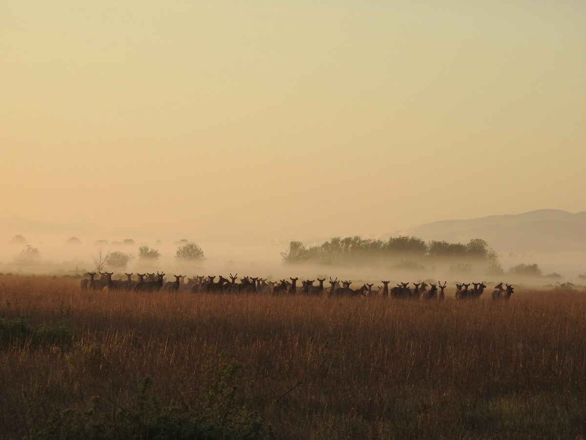
Elk – Elk Run Trail, 10/11/25.

Mountain goats – Mt. Rainier National Park, 08/05/25.
Being fortunate enough to witness animals in their natural habitat is one of the perks of hiking and we hope to see many more this coming year. We’re still on the lookout for several species that are possibilities. Most notable and likely of these are porcupines, giant pacific salamanders, and cougars. Much less likely but possible are wolves, wolverines, and moose among others. Happy Trails!


 This trail is part of the
 Damaged footbridge over Morganroth Creek at the 0.2-mile mark.
 The Wetland Loop Trail split off just beyond Morganroth Creek. I stayed right and planned on returning via the loop.
 This was a muddy trail which isn’t surprising for an area that receives 120″ of rain (3 meters) on average annually.
 Youth-on-Age
 Approaching the Bogachiel River.
 Bogachiel River
 The other end of the Wetland Loop was approximately a half mile from the Olympic National Park boundary.
 Kahkwa Creek. The log down in the distance was crossable but I opted to ford the creek on my first pass.
 Ford at Kahkwa Creek.
 Signs at the park boundary. The trail name changes here to the Bogachiel River Trail.
 Wilderness permits for back country camping. At this point I was not only in the park but also the

 The dry creek where I turned around.
 The log crossing over Kahkwa Creek.
 The Wetland Loop Trail junction was near the Kahkwa Creek crossing.
 The Wetland Loop began along Kahkwa Creek.

 Skunk cabbage
 The Wetland Loop traversed up and down along a hillside above some wetlands.
 Scouler’s corydalis
 Wetlands below the loop trail.
 Completing the loop.
 Fairy lanterns


 Notice regarding the petroglyphs on Wedding Rocks. By the time we were on the beach we’d completely forgot to look for these. We did run into another hiker who had seen them on a prior trip, but he couldn’t remember where. He thought they were located at some rocks near where we’d run into him, so we searched those rocks for several minutes with no luck. As it turns out he was mistaken as to where Wedding Rocks was, it is located on the first rocky headland nearest Cape Alava at the northern end of the triangle hike. We were much closer to the southern end.
 Ozette River leaving Ozette Lake.

 Bunchberry
 Skunk cabbage
 Bog laurel along the trail.
 Closer look at the bog laurel blossoms.
 Squirrel
 First view of the ocean.
 Beach bunny
 Ozette Island. The signpost is used to identify inland trails that bypass the beach.
 Heading south along the beach.
 We had heard sea lions somewhere in the direction of Ozette Island as we were approaching the beach.
 There is a seal in the foreground and a couple of sea lions on the rocks beyond.
 One of several campsites along the beach.

 Approaching Wedding Rocks. There is a bypass sign ahead if you look closely. At higher tides it is not possible to go around the rocks along the beach.
 A couple of crabs taking a defensive position as we were passing by.
 Wedding Rocks
 On the other side of the Wedding Rocks. As I mentioned before this is where the petroglyphs are, but we’d already forgotten to be looking for them. In Heather’s defense she had started to come down with a cold the previous day and was not feeling 100%. I however had no excuse.

 Looking back at the Wedding Rocks.
 Robin
Robin Bald eagle
 Whimbrel
 Hole in a sea stack.
 Seals and cormorants
 The second rocky headland where there was an inland bypass route. On the far side is where we ran into the hiker who thought these were the Wedding Rocks where he’d seen the petroglyphs before.
 Path through the rocks. It made sense to us that this would be where the petroglyphs were given there were several passages between the rocks here.
 Coming out the other side.
 Looking back at the rocks that weren’t the Wedding Rocks.
 Sandpoint ahead.
 Semipalmated plover
 View south
 One of the groups of backpackers heading north from Sand Point.
 Chickweed on the headland.


 Evergreen huckleberry blossoms.
 Bench along the trail.
 Groundcone. Heather had a sharp eye to pick this up on the forest floor.
 There were a couple of missing sections of boardwalk along this side of the triangle.
 Ozette Lake

 Map of the area trails at the trailhead.
 Anyone know why the spelling on the sign is different?
 Violets
 Bridge over an unnamed creek.
 Trillium
 Coltsfoot
 Fairy bells


 Depending on the volume of water there are up to four channels which was the situation on this day.
 Heather on the bridge above the falls.


 Storm King Ranger Station
 Forget-me-nots (non-native) along the trail.
 Lake Crescent

 Storm King Trail to the left.
 Marymere Falls Trail junction with the Barnes Creek Trail.
 Footbridge over Barnes Creek.
 Barnes Creek
 Trillium
 Footbridge over Falls Creek almost immediately after crossing Barnes Creek.
 Falls Creek
 Start of the clockwise loop.

 Marymere Falls
 The trail climbing up from the first viewpoint.
 Marymere Falls from the second viewpoint.
 Final viewpoint before the loop curved away from the falls and descended back to its start.
 The footbridges over the two creeks.
 Unnamed fall on Falls Creek from the footbridge.
 It was now almost 9am so there were a few cars parked here already.

 Various poems were located along the first mile of the trail.
 Haiku
Haiku

 A second haiku.
 Common whipplea
 Starflower
 Valerian
 Clear water in Lake Crescent.
 Paintbrush
 Something in the pea family.
 Nearing Devil’s Punchbowl.
 There was a fair amount of poison oak along the trail to Devil’s Punchbowl.
 Madrones
 Honeysuckle
 Common cryptantha
 Rejoining the railroad trail on the far side of the tunnel.
 Another type of trail user.
 View west.
 View east.
 Big deervetch
 Fairy slippers
 Woodpecker
 Lake Crescent Lodge on the far side of the lake.
 Wallflower
 The second tunnel.
 Thimbleberry
 White crowned sparrow
 Going through the tunnel.
 I went a little further around this bend while Heather took a seat on a log after exiting the tunnel.
 Paintbrush
 View across the lake toward the Barnes Creek Valley.
 I believe the snowiest peak is Lizard Head Peak.
 Saxifrage
 Chickweed
 Swallow
 Oregon sunshine
 Lupine
 Stonecrop
 Variable-leaf collomia

 This was a longer tunnel and had little light near the middle.
 Descending to the trailhead.

 The lake from the picnic table.
 Common loon
 These mallards came flying in then waddled up to see if they could scrounge something from us, but we explained that we do not feed the wildlife (
 Stellar’s jay
 Trying to find the route to the lodge.
 Mushroom
 The lodge is just on the other side.


 Interpretive signs explaining the creation of Lake Crescent by glaciers.
 This trail had good signage unlike the area near Bovee’s Meadow.

 Chair near the lodge.
 Lake Crescent Lodge.


 Hall of Mosses pointer.
 Spring fed Taft Creek.
 Start of the one-way loop.
 Interpretive sign along the loop.
 Looking up from the interpretive sign.
 Maple Grove
 Nursery log

 Fallen sign for the Spruce Nature Trail.

 This was another interpretive loop.
 Hoh River from the trail.
 This huge root ball was hosting its own mini forest.
 The trail extends all the way up to Glacier Meadows below Mt. Olympus.
 Violet
 Fungi
Fungi
 Another type of violet.
 Hoh River
 Bunchberry and strawberry bramble
 Trillium
 Squirrel
 One of the “ups”.
 Star flower
 Hoh River
 Mineral Creek
 Scouler’s corydalis along Mineral Creek.
 Mineral Creek Falls
 Unnamed creek a short distance beyond Mineral Creek.
 Waterfall on the unnamed creek.
 Sign for the spur trail to Mount Tom Creek Camp.
 Wren
Wren
 Vanilla leaf
 Water droplet on a vanilla leaf.
 More violets
 Salmonberry along the trail.
 Big leaf maple canopy.
 There were a few obstacles such as this closer to 5 Mile Island.
 Cougar Creek crossing.
 Marker at the spur trail for 5 Mile Island Camp.
 Hoh River at 5 Mile Island Camp.
 View upriver from the same spot.
 Privy at 5 Mile Island Camp.
 Crow
Crow Cat Peak, Mount Carrie, and Ruth Peak partly under clouds.
 Cat Peak
 We saw a lot of robins, on this hike and the over the next four days.
 Slug
Slug
 Candy flower
 Almost back to the trailhead.
