**Note the 2024 Young Grasshopper Fire burned over a portion of this hike including Grasshopper Meadow.**
In 2017 we did an overnight backpack to Grasshopper Meadow via Chucksney Mountain (post). During that trip we hiked a 9.8-mile section of the 13.5-mile long Grasshopper Mountain Trail #3569. The section covered was from the Box Canyon Trailhead to the base of Grasshopper Mountain. The trail does not go up the mountain’s summit but instead from the saddle at the base heads around the mountain and then follows Hiyu Ridge down to the Grasshopper Trailhead (approx 4 miles from the saddle).
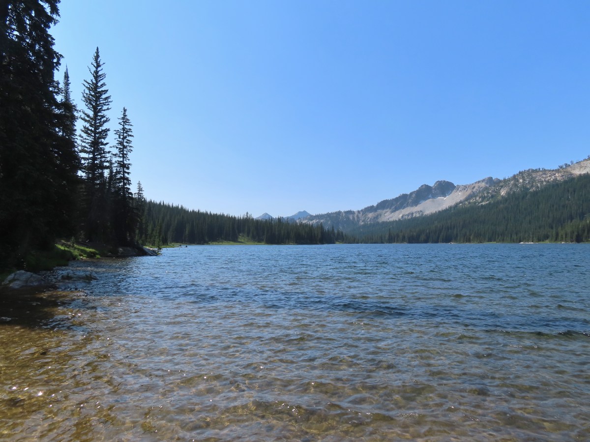
Grasshopper Meadow was a beautiful destination making a second visit appealing and including the remainder of the Grasshopper Mountain Trail pushed it up on our list of planned hikes. We had a decision to make regarding where to start for this second visit though. In his “100 Hikes Central Oregon Cascades” guidebook Sullivan includes the hike from the Grasshopper Trailhead along Hiyu Ridge in the more hikes section at the back of the book. He also includes a hike to Grasshopper Meadow via the Grasshopper Meadow Trail in the back of the book beginning 850′ below the ridge at the top of the meadow at what is marked on Google Maps as the Grasshopper Meadow Trailhead. Hike Oregon also covers the same hike on their website here. Interestingly the Forest Service map and website do not mention this trailhead, but they do show the Grasshopper Meadow Trail #3314. We opted to start at the Grasshopper Meadow Trailhead for two main reasons. First it would allow us to pass through Grasshopper Meadow at two different times of the day instead of it being our turnaround point. The second, and more important reason, was Sullivan’s description of the hike along Hiyu Ridge indicated that we should be prepared to step over some logs. That’s code for lack of trail maintenance which could mean that this section of the trail could be impassable. The Forest Service website didn’t provide any trail conditions. We could have called to check, but we figured worst case scenario we could redo some of the 2017 hike if necessary.

A word of warning regarding the drive to this trailhead. There was about a half mile section of Road 1929 where a good amount of gullying has occurred. We’d recommend high clearance, but somehow there was a Toyota Prius parked here (just out of frame).
The trail began with a gradual climb through a mixed conifer forest before steepening as the meadows began.
 Valerian along the trail.
 Vanilla leaf and anemones carpeting the forest floor.
There were wildflowers along the vast majority of this hike which resulted in our taking way too many photos. I will try and limit what I include here, just know that what gets shared will be a small portion of what we saw.
 Star-flowered false solomonseal.

 Coneflower with lupine behind.

 Penstemon

Near the three-quarter mile mark we took a short spur trail to the left to visit a spring at the base of a post.


 Monkeyflower
We continued steeply uphill from the spring for 0.3-miles where we took another short spur trail, this time to the right and a view of Diamond Peak.

 Lupine
 Sub-alpine mariposa lily
 Moth on fleabane.
 Waterleaf
 Tiger lily
 Pussytoes

 From left to right the peaks with snow are: The Twins (post), Maiden Peak (post), Fuji Mountain (post), and Diamond Peak (post).
 Diamond Peak
We continued uphill from the viewpoint following the trail to a post in a large rocky area that was filled with larkspur.

 Grasshopper Mountain above the meadow.
 The post in the rocky area.
 When we visited in 2017 it had been mid-July, and the larkspur show was over.
The Grasshopper Meadow Trail ends at these rocks for all intents and purposes. There is no clear path from the post up to the Grasshopper Mountain Trail which is approximately 150′ above running along the ridge. We made our way uphill trying to avoid as many plants as possible and picked up the trail which was marked by periodic rock cairns.
 A cairn marks the Grasshopper Mountain Trail.
We turned left on the trail and headed toward Grasshopper Mountain.


 Looking out over the meadow.
 Fuji Mountain and Diamond Peak
 The saddle below Grasshopper Mountain.
From the ridgetop we gained a view to the NE which included the Three Sisters, Broken Top, and Mt. Bachelor (post).

 The Three Sisters and Broken Top
 Mt. Bachelor
We crossed over the ridge and continued on the Grasshopper Mountain Trail which was, as we had suspected, in need of some trail maintenance.
 The last of the snow, at least it is all we saw.
 Glacier lilies near the tiny snow patch.

 It was evident that the trail does get maintained on occasion, but none of it appeared recent near Grasshopper Mountain.
Crossing over the ridge changed the mix of wildflowers we’d been seeing adding in some early season bloomers such as trillium.

 Anemone
 Violets
 Bleeding heart
 Oregon bluebells
The trail passed through a small fire scar on the backside of Grasshopper Mountain where we had to briefly leave the trail to find a way over and around blowdown.

 The Three Sisters and Broken Top were visible from this area.
 Back on the slightly overgrown trail.
As we made our way through the fire scar more mountains joined the view including Mt. Washington, Three Fingered Jack, and Mt. Jefferson.

 Mt. Jefferson and Three Fingered Jack
 Bears appear to use the trail more than hikers. This was the largest of three piles we’d pass on the day.
 Arnica
After navigating the fire scar we were able to more or less stay on the tread save for a couple of brief detours around blowdown. That being said there were numerous trees that we had to step, or in some cases climb over. There were also numerous burrows to watch out for along with a lot of forest debris which made for a slow and hard hike. The other thing that slowed us down was the sheer number and variety of flowers.
 This is both the trail and a front (back) door.
 Valerian and tall bluebells
 Fairy bells
 Meadowrue
 Moth on valerian.
 Jacob’s-ladder
 While the trail was overgrown in places it was passable and the tread was in pretty good shape.
 Fringecup
 Possibly a speedwell but unsure and it was the only one we saw.
 More blowdown to maneuver around.
 Edith’s checkerspot
 Trail passing through an area full of monkeyflower and larkspur.
 Cinquefoil, larkspur, and buckwheat
 Scarlet gilia
 Paintbrush
 Bluehead gilia and silverleaf phacelia
Approximately 1.5-miles from the saddle below Grasshopper Mountain the trail again crossed the ridge to avoid a rocky cliff area.
 The rocky area from the trail as it crossed the ridge.
We could see that there were a lot of flowers on the rocks, but the trail dropped below the ridge quickly and my first attempt to scramble up to see the flowers was too soon and I just ended up in the brush on the ridgetop. On our way back I tried again, this time finding the correct spot where I was awarded not only with the amazing flowers but also another great mountain view.
 Columbine crowding the trail.

 The wildflower covered rocks on the way back.
 Arrowleaf buckwheat and Oregon sunshine
 The Three Sisters and Broken Top with some clouds moving in.


 Paintbrush surrounded by buckwheat, bluehead gilia, and stonecrop.
 Scarlet gilia
 Wallflower
 Wild rose
The trail stayed on the west side of the ridge for the remaining 2.3-miles. Just over a third of a mile from the rocky viewpoint the trail passed a small rock outcrop which we thought looked like and it might be a good spot for a break on the way back. Not far beyond the outcrop we came to another tricky downed log where Heather decided that was enough. She would go back to the outcrop and while I would continue. If the trail was passable I would continue for no more than 45 minutes as it looked like that would be enough time to reach the Grasshopper Trailhead based on the distance shown on the GPS.

 Beargrass near the outcrop.
 The outcrop from the trail.
 Blowdown
 More blowdown
 Western meadow fritillary
 Bunchberry
 Recent trail maintenance! There were a couple of cut trees in the final mile, but there were also still many to step over.
I had misjudged two things when Heather and I had split up. One was just how far the trailhead was, and the other was how much elevation I would be losing to get there.
 The trail dropped low enough that there were several rhododendron blooming.
 Queen’s cup.
 South Sister (post) and Broken Top (post).
It turned out I had been almost 2-miles from the trailhead and needed to lose over 850′ of elevation to reach it. Luckily the trail was in a little better shape at this end again. I was able to keep a good pace and I arrived at Grasshopper Saddle with a couple of minutes to spare.


Given that the Forest Service lists this as an official trailhead I was expecting a little more than a post with a road number and a faded laminated sheet of paper.
 Had I not just come down the trail I might not have even noticed it was there.
 Cardwell’s penstemon
I realized on my way down that while I was making good time going in that direction, I was going to be hard pressed to maintain the same pace going uphill. Fortunately for me it wasn’t a particularly warm day, so it only took me an extra five minutes to make it back to the outcrop. When I joined Heather on the outcrop she said she was just starting to wonder if she should start to worry. (I might have made a little better time had I not kept taking pictures, but then again, those breaks let me catch my breath.)
 Starflower
 Ginger
 Mt. Bachelor through the trees.
 Musk monkeyflower
 Grasshopper Mountain from the outcrop.

 Cliff beardtongue
After I took a much-needed break we headed back. We kept our eyes out for flowers we’d missed on our first pass while we watched the various pollinators visiting the blossoms.
 Blue-eyed Mary
 Cicada, not a pollinator but interesting to see.
 Solomonseal
 Variable-leaf collomia
 Honeysuckle
 Oregon grape
 Pollinator 1
 Pollinator 2
 Pollinator 3 (Clodius parnassian)
 Bees on bastard toadflax
 Checkerspot on groundsel
 Naked broomrape (Aphyllon purpureum)
 Penstemon
 Our guess is this is mile three from Grasshopper Saddle. We didn’t notice any other numbers and missed this one on our first pass.
 Dwarf bramble
 Strawberry

 Cinquefoil
 It started clouding up in the afternoon.
 Back at the saddle below Grasshopper Mountain.
We took another break shortly after reaching Grasshopper Meadow then headed down to the spring where we both cooled off using the spring water.

 Great artic butterfly. There were a lot of these flying about. Their dorsum is a bright orange, but they rarely would open their wings when they landed.
 The checkerspots on the other hand are happy to open their wings.
 False hellebore
 It clouded up over Diamond Peak as well.
 Lewis flax
 Orange agoseris
 A Lycaendae on a lupine leaf.
 Moth on a mariposa lily.
 Butterflies gathering at the spring.
After refreshing ourselves with the spring water we continued back to the trailhead where we found the Prius still there. We never saw or heard another person on this hike. Not seeing anyone along Hiyu Ridge isn’t all that surprising given the trail conditions, but not seeing anyone in the meadow was a little surprising.

 The Prius at the TH. We parked on the shoulder in a pullout.
The hike from trailhead to trailhead came to 11.5-miles (according to the GPS) with a little over 2000′ of elevation gain (according to the topo maps, and my legs).

Despite the rough trail conditions this was a beautiful hike. The flowers were the highlight, but there were several good mountain views scattered throughout. Hopefully the gullies in FR 1929 can be repaired or at least kept from getting any worse. Forest Road 1927 at Grasshopper Saddle seemed to be a good gravel road, but for that to be a viable option for anyone other than those that don’t mind a challenge the trail needs to be cleaned up. Happy Trails!
Flickr: Hiyu Ridge via Grasshopper Meadow

 Even at 6am on a Thursday the trailhead parking was nearly full.
 This was a neat feature.
 We both counted our steps, for me it was 50 and Heather 60.
 The Lostine River.
 Entering the Eagle Cap Wilderness just before the trails split.
 Trail sign at the fork.
 Bridge over the East Fork Lostine River.
 East Fork Lostine River
 The storm overnight had provided a little much needed rain.
 Huckleberries (I’d already picked the ripe ones.)

 Elkhorn Peak
 Monkshood

 Some of the river channels were very calm and crystal clear.
 We passed through a section of bent and snapped trees which were probably a result of an avalanche.

 Glacier Mountain
 Looking back at the other side of Elkhorn Peak.
 Nuttal’s linanthus
 Looking back down one of the steeper sections. We passed another couple heading out along this section.
 Looking up the Copper Creek drainage. Glacier Mountain on the left and Elkhorn Peak on the right.
 Off-trail waterfall. We could hear this from the trail, and it was a fairly easy bushwack to get a good view.
 The river crossing.

 Yellow columbine
 A little hazy looking toward the Sun.

 Elephants head
 Unnamed creek
 An easier crossing of the river here.


 First view of Minam Lake.
 Minam Lake
 Common mergansers
 Needle Point is the peak in the distance to the far left.
 Shooting stars
 We could have stared at the rocks along the ridges for hours.
 Heading back.
 Violet
 Groundsquirrel
 Robin
Robin Fritillary
 Orange agoseris
 The fire was burning up in that basin somewhere.
 The talus section in the afternoon.
 Spirea

 Butterflies and moths were out in force.
 Police car moth and another interesting looking pollinator (out of focus).

 Prince’s pine
 Back at the junction with the East Fork Lostine River Trail.
 Left for hikers and right for stock.

 We managed to get started about ten minutes before 6am.


 Bugbane and paintbrush
 A 2022 wildfire burned the first 3-miles of the trail and left the old footbridge damaged. A steep scramble trail led down to it.
 Big Sheep Creek

 Paintbrush and lupine
 Wildfire smoke filling the valley behind us.


 Phacelia
 Butterfly on buckwheat.
 Some of the trees survived the fire.
 White mariposa lilies in a meadow along the trail.
 Junction with the Wing Ridge Trail.
 North Fork Big Sheep Creek
 Lewis Monkeyflower along the creek.


 Canada milk-vetch
 Grass-of-parnassus
 Bog orchid
 Checker-mallow
 Bee heading for some monkshood.
 Me in some fireweed.

 Getting eyed by a western tanager.


 When fires burn too hot they damage the soil which makes it difficult for all plants to obtain the necessary nutrients to grow.
 A few plants had been able to take hold.
 A healthy patch of paintbrush.
 Middle Fork Big Sheep Creek
 Monkeyflower
 Brook saxifrage
 Another severely burned section.
 The Bonny Lakes Trail forking to the right off of the Tenderfoot Wagon Road Trail.
 Wildflowers along the Bonny Lakes Trail.
 The wildflowers were profuse along this stretch of trail.
 American sawwort
 Police car moths
 Larkspur and fleabane
 The trail recrossed the Middle Fork Big Sheep Creek.
 Orange agoseris


 Taper tip onions
 White mariposa lilies


 False hellebore
 Checker-mallow
 Penstemon on the outcrop.
 Mountain larkspur
 Pika!
Pika! Gathering plants for the Winter store.


 On the steep climb.
 Mountain heather
 Ground squirrel
 The creek was below between the ridges here.

 Stonecrop
 Swamp onions

 Wallowa paintbrush
 Aneroid Mountain and Lower Bonny Lake.
 Aneroid Mountain to the right and an unnamed peak on the left.


 Shrubby cinquefoil
 Cutleaf anemone seed heads.
 Possibly a sandwort.

 Upper Bonny Lake
 Lower Bonny Lake
 Aneroid Mountain from the knoll.

 Spotted sandpiper
 Elephants head

 White mariposa lily and buckwheat
 Jacob’s ladder
 Checker-mallow and white mariposa lilies along the trail.
 Scouler’s woolly-weed

 Gentians

 Goldenrod and yarrow
 Nuttal’s linanthus


 North Fork Big Sheep Creek
 The haze from the morning had improved now that the Sun had moved on from the east.
 Looking down at the un-damaged bridge over a side stream.
 Yellow columbine
 Big Sheep Creek.


 East Peak
 Spreading dogbane
 The start of the McCully Creek Trail (to the left).


 Paintbrush and pussytoes along with the lupine.
 Pink pyrola
 Monkshood
 Tall bulebells
 Penstemon
 Entering the Eagle Cap Wilderness.
 Yellow columbine
 Arnica and fleabane
 Coiled lousewort
 The McCully Creek crossing.
 Elephants head at the crossing.
 Paintbrush in the meadow.
 Fleabane (or aster) in the meadow.
 Wallowa paintbrush
 Cusick’s speedwell

 The first blowdown we encountered.

 Heading cross-country to McCully Creek.
 Where I recrossed the creek.
  Heading down to a flat opening which could serve as a campsite.
 Arriving at the first meadow.
 Aneroid Mountain

 A few flowers in the meadow.
 Bistort
 Shooting stars

 Looking down toward where I left the trail to bushwack to the meadow.
 Jacob’s ladder
 Orange agoseris
 Fritillary
 Crescent
 Bog orchid
 Tortoiseshell
 Red-breasted nuthatch


 The gate on the service road had been opened at some point.
 Swallowtail


 Canadian milk-vetch
 The Falls Creek Trail on the right.


 Mock orange
 The Falls Creek crossing.
 Twin Peaks from Falls Creek.
 Geranium
 Paintbrush

 A paintbrush hiding in fleabane.
 Robin
Robin The trail crossed a rocky area caused by an avalanche.
 Doe with one of her two fawns that were down at the creek at the avalanche area.
 Mountain death-camas
 The Hurwal Divide to the left of Sacajawea Peak.
 Rosy pussytoes
 Hurricane Divide (south)

 Deadman Creek
 Western tanager
 Hurricane Creek


 Slick Rock Creek flowing down from the right in the distance.


 The creek crossing.
 Harebells and stonecrop
 Paintbrush below the falls.
 Arnica
 Wallowa paintbrush, yellow columbine, milk-vetch, and northern sweetvetch.
 Faint rainbow in the falls.
 Butterfly on Rocky Mountain goldenrod.
 Yellow fleabane
 This may be common butterwort, but I’m not positive.
 Yellow columbine
 Spider hunting a moth. There was a brief scuffle, but the moth escaped unharmed.
 Penstemon

 Sagebrush mariposa lily

 Despite all the wildfires the views were pretty good as long as the Sun was at our backs.


 Nuttal’s linathus
 Wood nymph
 There was haze to our backs though.
 Rose along the trail.
 A Sulphur butterfly.
 A pale crescent on fleabane.
 It was warm and smokey at the viewpoint.

 Yarrow
 White mariposa lily
 Aster
Aster Sulphur buckwheat
 Scarlet gilia
 Bee visiting some penstemon
 Imnaha River canyon
 A small section of the loop was lost in a 2022 wildfire.
 The other end of the missing trail.
 One of several interpretive signs along the loop.
 Nettle-leaf giant hyssop
 This appeared to be the last of the elkhorn clarkia in bloom.
 Looking down wasn’t bad, but we couldn’t really make out any of the mountain peaks in the distance.
 Taper-tip onions
 A smokey Sun was heating things up fast.
 Grouse
 One of a pair of hawks.
 The Hat Point Lookout from the parking area.
 Paintbrush
 The start of the loop.
 Fireweed
 The lookout staffer?
 Sunlight reflecting off of the Snake River in Hells Canyon.
 Hidden in the haze are the Seven Devils mountains in Idaho.
 Penstemon
 The tower was closed to the public due to safety concerns.

 Hells Canyon is deeper than the Grand Canyon from its highest point, 9,393′ He Devil in Idaho at 8,043′ from the river. The depth from Hat Point to the river is 5,632′.
 Mountain coyote mint
 Lewis flax


 The tread was faint in spots amid the patches of wildflowers.
 There was a small rock outcrop at the ridge end.
 This is where we turned around not wanting to lose anymore elevation and have to climb back up on what was already an uncomfortably warm day. As it turns out we were just about at the boundary of the
  The lookout from our turn around point.


 Hat Point Trail sign near the quarters.
 This trailhead sign was in a large parking area near the quarters, but there were “No Parking” signs along the road here.
 Lupine

 Imnaha River canyon
 Imnaha from the Five Mile Overlook.
 The unsigned trail enters the forest across from a small pullout.
 Bunchberry


 Fish
Fish Rough skinned newt


 Flagging and some old trail maintenance along the Baty Butte Trail.
 We could see the tread continuing on the other side of the thicket.
 Vegetation covering the trail.
 The trailhead is located at a turnaround at the end of BLM road 7-4E-11.1.
 Oregon sunshine, lupine and paintbrush.
 Larkspur, paintbrush, and Oregon sunshine.
 Penstemon, paintbrush, and valerian.

 Westen featherbells
 Bistort
 Arnica

 Bear sign on the trail.
 Paintbrush and lousewort
 Nasty Rock from the trail.
 Entering the fire scar.
 The trail was especially overgrown in the fire scar.
 Penstemon
 Columbine along the trail.
 Valerian
 Exiting the fire scar after less than 100 yards.
 While none of the several downed trees posed much of an issue the condition of the trail made for slow going.

 Nasty Rock sticking up ahead.
 Not Nasty Rock further along the ridge and in the Beachie Creek fire scar.
 Wildflowers were blooming in the openings along the ridge.
 Arrowleaf buckwheat
 Checkerspot on Oregon sunshine
 Oregon sunshine
 Table Rock (
 Mt. Hood peecking up from behind a ridge.
 Scarlet gilia
 Nasty Rock from the trail.
 Flowers below the trail.
 Flowers above the trail.
 Buckwheat


 There were a lot of nice Washington lilies below Nasty Rock with more to come over the next week or two.
 Wintergreen
 Nasty Rock from the trail.
 The trail below Nasty Rock.
 Nasty Rock from the end of the “trail”. Prior to the 2020 fire a rougher use trail continued on to Not Nasty Rock, but we didn’t see any obvious tread. (We weren’t really looking though either.) We made the fairly easy scramble to the top of Nasty Rock and took a short break.
 Mt. Jefferson from Nasty Rock.
 Mt. Jefferson with the flat-topped Battle Ax (
 Mt. Hood in the distance.

 Looking out across the Molalla River drainage to the Table Rock Wilderness.
 Rooster Rock is the rock outcrop to the left with Table Rock the tall feature to the right. Pechuck Lookout can be seen on the lower hilltop in the center foreground.
 Not Nasty Rock from Nasty Rock. The highest peak diagonally left of Not Nasty Rock is Rocky Top (
 We were joined at the summit by a swarm of flying ants obsessed with this fir tree.
 Checkerspot on Oregon sunshine
 Swallowtail resting on serviceberry.
 Blue bells of Scotland
 Fritillaries on mountain coyote mint
 Clodius parnassian on mountain coyote mint.
 Fleabane
 Buckwheats, paintbrush, Oregon sunshine and at least one butterfly.
 Scarlet gilia
 Larkspur
 Washington lily
 Inside-out flower
 Fritillary
 Beardtongue
 Pink pyrola
 Bead lily a.k.a. Queen’s cup
 Bunchberry
 Cat’s ear mariposa lily
 Approaching the road.
 Larkspur and yarrow
 Checkerspots on Oregon sunshine


 Ash Creek


 In addition to the single doe we spotted a variety of birds along our route.
 Passing the dog park.
 Sign at the start of the sports park.
 Bird in a nest.
 Interpretive sign along the trail.

 Stellar’s jay
 Flowers along the path.
 Eventually the field on the left will be developed into sports fields.
 Vetch
Vetch Morning sunlight showing why it’s a robin “red breast”.
 Sparrow
 Going around the open field brought is into the sunlight, but it still hadn’t warmed up too much.
 Swallows
 Spotted towhee with breakfast.
 Amphitheater at Riverview Park.
 Willamette River
 Killdeer


 Pointers on South Main Street.


 Signboard about a tenth of a mile from the trailhead.
 The loop began on the far side of the footbridge.
 As far as we could remember we’d never seen a bench on the other side of a fence before.
 Middle Fork Willamette River through the vegetation.
 Tiger lily
 Self-heal
 Snail
Snail Mock orange

 Anemone
 There are a few junctions prior to reaching the footbridge. The first was the only one with any signage. We stayed on the correct trail by ignoring side trails to the left that headed uphill and on the right that led down to Deception Creek.
 We turned left at the signed junction following half a sign for the Deception Butte Trail.

 At the last unsigned junction there was a signboard, but with nothing on it. (We went straight.)
 Warning sign for the burned area ahead.
 The footbridge over Deception Creek.
 Deception Creek

 The amount of trail work needed to clear the trail was evident by the sheer number of cut trees along the length of the trail.
 This was from 2017 near the same stretch of trail.
 View up the canyon from the trail.
 Clodius parnassian
 There was a lot of vegetation along the trail, so we had to keep an eye out for poison oak which was present at times on the lower two-thirds of the trail. It was never much of a problem, but there were a couple of plants crowding the trail that we had to maneuver around.
 Moth
Moth Starflower
 Rhododendron
 Northern cloudywing
 Big deervetch
 Hummingbird
 Groundsel
 One of the damaged sections of trail.
 There was some forest that survived the fire starting near the 3.5-mile mark where the fire burned less intensely.
 Townsend’s solitaire
 Canada jay
 There were a few views of the Three Sisters through the remaining trees. (Middle & South Sister here)
 Inside-out flower
 Looking up as the trail neared the summit.
 Woodpecker
 Common whipplea
 Anemone
 The Deception Butte Trail arriving at Deception Butte.
 Beargrass


 Looking down at the saddle and wondering if it was really worth having to climb back up.
 Northern flicker
 Lizard
 Rock outcrop on the other side of the saddle.
 Tolmie’s mariposa lilies
 Bluehead gilia
 Squirrel
 Oakridge in the valley below with Diamond Peak (
 Diamond Peak
 Oakridge
 Leafy fleabane
 Oregon sunshine on the hillside looking up Deception Butte from the saddle.
 Wild onion
 One of the fritillary butterflies.
 Fly inside a Tolmie’s mariposa lily.
 There is a very steep trail just below the summit that leads to an upper trailhead. The Forest Service does not recommend using these though as the trail is said to be slippery and steep. We can vouch for the steep just by having looked down from the Deception Butte Trail.
 Plectris and stonecrop
 Coralroot
 The best view of the Three Sisters that we got all day.
 Butterflies enjoying some vetch. There were at least a half dozen butterflies visiting this patch.
 Brown creeper
 Pink pyrola

 Pearly everlasting
 Turkey vulture
 Fireweed
 Entering the trees near the footbridge over Deception Creek.
 Columbine
 Tiger lilies


 There were some nice rhododendron blooms along the trail.
 Spotted coralroot
 The first of three crossings of FR 411, this is at the 0.4-mile mark.
 Inside-out flower
 Starflower
 Yellowleaf iris
 The trail is narrow at times but well maintiained.
 Forest filled with rhododendron.
 A closer look at the rhodies.
 There were several madrones in the forest.
 Little prince’s pine
 Sugar sticks
 There were a few places where we might have had a view if not for the clouds.
 Stonecrop
 Passing below some of the rock formations.


 Anemones
 Bleeding heart

 The first small meadow that the trail passed through was full of blue-eyed Mary.

 Northern phlox
 Coming up on another small meadow.
 Subalpine mariposa lily
 Beargrass
 The fog didn’t help with our trying to find the trail. There was enough room along this section of road that parking and starting the hike from here would be possible.
 Back on trail.
 Honeysuckle
 More northern phlox
 This meadow was full of bluehead gilia.


 The trail dropped steeply as it rejoined FR 411.
 There was no parking room that we could see near this area.
 Vanilla leaf along the trail.

 Bunchberry
 Trillium
 We stopped when we spotted something in the trail ahead that looked like it might be an animal. Using the camera to zoom we realized it was a grouse hen with her little chicks.
 The hen got up and then the chicks headed into the underbrush. We felt bad having disturbed them, but once they’d moved, we calmly passed by while momma came back to gather her little ones.
 This was all beargrass, but none of the plants in this area appeared to be planning on blooming this year.
 Hermit thrush
 The rocky summit of MacDuff Mountain.
 A lot of larkspur.
 Subalpine mariposa lilies
 Paintbrush and buckwheat
 Cinquefoil
 A penstemon


 The view from the top.
 No blue sky that way.
 No sign of clearing this way either.
 Cliff beardtongue
 Woodland-stars
 Paintbrush
 Hey look, there is another ridge over there.
 Ookow just starting to open up.
 Steep climb or road walk? We chose the trail again on the way back.
 A wetter road now thanks to the rain shower.
 Blue sky, it does exist.
 The clouds got a late start but eventually started lifting.
 From this angle it looks like a statue.
 Looking down from some of the switchbacks.
 Cougar Reservoir
 Pyrola
 Sunlight!
 I’ve never seen a track this far off.
 The track after manually editing it.