For our second vacation hike in the Wallowa Mountains we set our sights on the Pine Lakes Trail. This was another of the 100 featured hikes in William L. Sullivan’s “100 Hikes Eastern Oregon” 1st edition (2022) and would be number 96 for us on our quest to finish all 100 (post). Sullivan gives two out-and-back option for this trail, a 4.2-mile hike to Chute Falls and a 14.8-mile hike to Pine Lakes.
Heather and I had already decided that I would try for the lakes while she was going to aim for Chute Falls. She has continued to struggle with a breathing issue which has caused her to keep a slower pace than in years past making longer hikes problematic from a time standpoint. Our plan was to set off at our own paces and Heather would wait for me at or near Chute Falls. We also established a timeframe in which she should expect me.
The hike begins at the Cornucopia Trailhead which is on private land owned by the Cornucopia Lodge and Packstation. We followed pointers at the lodge to the current parking area.


The current trailhead was approximately half mile from where the public parking area was in Sullivan’s description. That meant an extra mile of hiking for each of us. I threw my pack on and set off on the private road following pointers for the Pine Lakes Trail.
 This pointer refers to trail 1880 as “Pine Creek” but other signs and the Forest Service website refer to it as “Pine Lakes”.
 This one says Pine Lakes.
 Sign for the Packstation.
As I neared the packstation a pair of dogs noisily raced toward me, one a German shepherd. Luckily they were all bark and no bite, but it got my adrenaline pumping. I continued on passing the forest boundary and the small parking area Sullivan had described.
 Squirrel with breakfast at the packstation.

The trail follows an old roadbed for most of the first 2.1 miles.
 Old footbridge over a dry creek bed. It didn’t look particularly safe so I stuck to the road.
 The dry creek bed crossing.
Shortly beyond the dry creek bed I came to the East Fork Pine Creek where a pair of cow elk dashed across the trail and disappeared in the underbrush.

Seeing the elk was exciting. Less exciting was seeing the actual cows after crossing the footbridge. In typical cow fashion their plan for avoiding me was to get onto the trail ahead of me and walk 10 to 20 yards down trail then turn around to see if I was still following.
 Black cows on the trail ahead.
Meanwhile Heather was taking pictures of flowers along the road to the packstation.
 Coneflower
 Snowberry
Try as I might to convince the cows that they simply needed to step off the trail to either side they were convinced that sticking to the trail, and booby trapping it with fresh pies, was the best way to lose me.

 West Fork Pine Creek
 Formation on the hillside.
 Western clematis
 Paintbrush
 Fireweed
Approximately a mile beyond the packstation I arrived at the first of two bridges over the West Fork Pine Creek. I briefly lost the cows here when they forked right along the creek while I crossed the slightly damaged bride.
 The bridge felt stable despite being slanted at a 45-degree angle.
I picked up my pace hoping to beat the cows to the second bridge which was another 1.1-miles up the trail.

 View from the trail.

I could hear and see the cows on the far side of the creek, and now they seemed to be racing me to the second bridge. Before getting that far I met a second group of cattle on my side of the creek near a ford where the fist group of cows were now crossing. Lucky for me this new group was a little smarter and they led the first group off trail into the brush leaving me cow free.

 The second bridge.
 West Fork Pine Creek
 Heather caught this cool cloud from her currently cow free hike. (She would run into them later where they’d ducked off the trail in front of me.)
Not far from the bridge was an established campsite just before the trail began to switchback uphill.
 Looking back down at the campsite.
Chute Falls is located slightly off-trail near a righthand switchback 0.3-miles from the second bridge.
 The use trail straight ahead at the switchback.
I followed the steep use trail 150 yards to Chute Falls.

I carefully made my way down to the base of the falls.

 The base of Chute Falls.

After visiting the falls I returned to the trail and continued to climb toward Pine Lakes. The trail switchbacked past the 10′ upper tier of Chute Falls.

I continued uphill through the forest past a view of a waterfall on the Middle Fork Pine Creek and passed into the Eagle Cap Wilderness 1.2-miles beyond Chute Falls.


 Looking back down the valley.
 View up the valley.
 Wilderness sign on the tree marking the boundary.
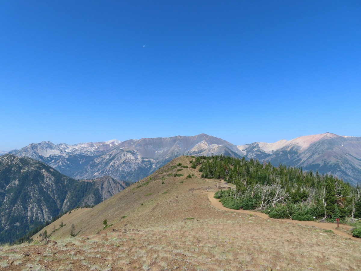
 The Pine Lakes are back up there somewhere.
The trail traversed a rocky hillside with excellent views for 0.8-miles after entering the wilderness before reaching another set of switchbacks. While the climb was gradual the rocky trail tread made for some tricky walking.

 Somewhere on the other side of the peaks on the left is the Schneider Cabin where we’d hiked the day before.

 Cliffs above the trail.

As I made my way across the rocks I tried to keep my eyes open for any larger animals on the surrounding hillsides. It wasn’t easy due to the tricky terrain, but it paid off when I spotted a few mountain goats on far side of the valley.
 I spy mountain goats!
 A zoomed in photo of the mountain goats.
I kept my eye on the goats as I continued.


I arrived at another set of switchbacks 0.8-miles from the wilderness boundary that climbed uphill through a rock field where I spotted a single pika that dashed out of sight before I could get a photo.


 I believe that is Cornucopia Peak on the left.
 Going up.
 Fireweed above the trail.
Above the switchbacks the trail leveled out a bit then descended to a basin with a mixture of forest and meadows.

 Paintbrush along the trail.

 The forest on the other side of the pass.
 West Fork Pine Creek
 There was a large waterfall flowing down from the outlet of the Pine Lakes. (Not West Fork Pine Creek whose headwaters were beyond the meadowed basin.

 West Fork Pine Creek begins somewhere above the basin at the far end.

 Rock formations along the cliffs.
 Arnica and pearly everlasting
 I tried to get a clearer look at the large waterfall but couldn’t find a clear line of sight.

Approximately 3.2-miles from Chute Falls the trail crossed the outlet creek.

 Gentians along the trail.
 Evidence of an avalanche at the far end of this meadow. It took a lot of trail maintenance to clear the snapped trees from the trail.
 Wildflowers lining the trail.

The trail began another series of switchbacks in order to climb above the waterfall and to Lower Pine Lake.
 A doe that turned out to be on the trail above me. There was a switchback just ahead of where I was.


 The forest in the basin.
 The Pine Lakes are in the basin ahead.
 Arnica and aster?
 Monkshood
 Seep along the trail.
 Grass of parnassus
 American sawort
 Something had been bedded down in this little bowl below the trail.
 Goldenrod
 The valley I’d come up to the right.
 Nearly 5-miles from Chute Falls I arrived at the dam at the outlet of Lower Pine Lake. A number of lakes in the Wallows were dammed to control water flow to the surrounding communities.
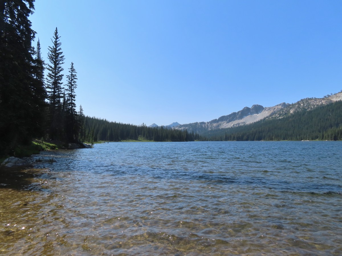
 Lower Pine Lake

The trail headed north around Lower Pine Lake arriving at Upper Pine Lake 0.2-miles from the dam.

 Lower Pine Lake

 Lower Pine Lake from between the two lakes.
 Upper Pine Lake from the same spot.
 Upper Pine Lake.
I did a little exploration along the eastern shore and then found a spot in the shade to take a brief break and change into a new pair of socks.


 The view from my break spot.
After my break I headed back to Chute Falls to locate Heather. Along the way I stopped for more photos and to look for pikas and mountain goats (to no avail).

 Shrubby cinquefoil

 White mariposa lily, the only one I spotted, and I’d missed it on the way up.
 Yellow columbine, I also missed this on the first pass.
 Dusky flycacther
 A meadow and the forest in the lower basin.
 Fritillary on pearly everlasting
 Trail maintenance in the avalanche section.
 Loved the rock colors in the area.
 I’m guessing some sort of wren.
 Caterpillers
I detoured to Chute Falls again to see if Heather was waiting there which she wasn’t, so I hiked down to the campsite where I found her waiting. While I was taking another break we started to talk about the falls and realized that Heather had missed the lower, larger, portion of Chute Falls. She had missed the first user trail and detoured at the next righthand switchback which brought her to the upper tier. I showed her a photo from my phone to confirm that she’d missed that part of the falls then, we hiked up together to check it out.
After making sure she’d seen the rest of Chute Falls we headed for the trailhead.

We picked up the cows again in between the two bridges and herded (followed) them back to where I’d picked up the first group at the East Fork Pine Creek before they finally turned off the trail.
 Herding the cattle back past the damaged bridge.
 West Fork Pine Creek.
 The footbridge across the East Fork Pine Creek ahead. We’d left the cows behind here and made our way back to the trailhead.
Given our starting point, three detours to Chute Falls and some exploring at Upper Pine Lake my hike came in at 16.4-miles and over 2700′ of elevation gain.

The rocky trail surface and amount of sun exposure added to the difficulty of this hike, but luckily there had been a fairly consistent cooling breeze which kept it from feeling too hot. The views were spectacular along the entire route and aside from the cows the variety of wildlife was great. We returned to Baker City and had dinner at the Eagle Cap Grill before turning in for the night for our last night in Baker City. We’d be moving our base to Enterprise the next day for the final three hikes of our trip. Happy Trails!
Flickr: Pine Lakes


 The trail entered the Eagle Cap Wilderness at the first switchback.

 Lewis monkeyflower
 Eagle Cap (post) in the distance.
 Chipmunk
 One of the switchbacks.
 Western tanager
 Pearly everlasting
 Paintbrush
 Baneberry
 Pika
Pika
 Bowman Creek
 Grass of parnassus
 The trail crossing Bowman Creek.
 Arnica
 Monkeyflower
 Bees on American sawort.


 Golden-mantled ground squirrel
 Another pika.
 Elderberry
 The lefthand fork led to a campsite and meadows in the basin.
 Gentians
 Meadow in Brownie Basin.
 The junction with the Chimney-Wood Trail.

 One of several pine siskins that were in these plants.
 Aster
Aster
 Fritillary
 Lupine and aster
 Butterfly on pearly everlasting

 Another western tanager.
 Gentians and St. Johnswort
 Lower Laverty Lake
 A patch of fireweed above the lake.
 Hooded ladies’-tresses
 American kestral
 Lower Laverty Lake
 Twin Peaks across the Lostine River valley.
 Eagle Cap at the far end of the valley.
 Heading for Chimney Lake.
 Chimney Lake
 Gentians along the lakeshore.
 The rocks ahead where we took our break.
 Islands in Chimney Lake.
 No matter how cute they are, please don’t feed the wildlife (Leave No Trace principle 6).
 Sulphur butterfly
 We heard more pikas than we saw. Here is the one, blurry, photo I managed to get.
 Milbert’s tortoiseshell
 Golden-mantle managing to feed itself.
 Twin Peaks
 Aster
Aster
 California tortoiseshell
 Grouse
 A comma, possible green comma.
 Back at the bridge over the Lostine River.
 Lostine River in the afternoon.


 Smoke rising from the Town Gulch fire to the south.
 Scarlet gilia
 Paintbrush
 Town Gulch Fire
 Penstemon
 Pearly everlasting and aster
 Big Lookout Mountain
 Summit Point Lookout from below.
 At the 0.7-mile mark the Cliff Creek Trail split off to the left while FR 7715 continued right.
 Cornucopia Peak
 The Summit Point Lookout with the Town Gulch Fire behind the forest below.


 The Elkhorn Range (
 The Elkhorns
 Finch
Finch The trail crossed a fence at the southern end of Little Eagle Meadows.
 Little Eagle Meadows and Cornucopia Peak.
 The wilderness sign in the distance.
 Birds on a wire.
 The views along the trail were amazing. In later July there is also a plethora of wildflowers along the route.
 Trail marker
 Ground squirrels
 We veered right here but had to be careful not to follow one of the many cow trails leading off into the meadows. Our GPS maps were helpful.
 Looking back up the hillside.
 Dry pond along the trail.
  Savage Peak is the round peak at the center.
 Heading toward Cornucopia Peak.
 The cabin was visible in the distance at times from the trail.
 Yarrow along the trail.
 Green around a small stream.
 The Schneider Cabin
 Cow at the cabin.


 View from the loft.

 Summit Point from the cabin.
 Summit Point Lookout
 Torn up trail tread.
 Cricket
 Tree full of mountain bluebirds.
 Arriving back at the fence.
 Hawk
Hawk Northern flicker
 Butterflies on Greene’s goldenweed.
 Fritillary butterfly
 Becker’s white
 Smoke from the Town Gulch fire.
 Insect on chicory.
 Arriving back at the trailhead.


 Memorial to pioneers dedicated by President Harding in 1923.


 The Cabin Loop sign pointed up this hill.
 Thistle
 Foam flower
 Coneflower
 There were virtually no signs to indicate what any of the trails were or where they led.
 We had to duck under this tree.
 Mountain lady slippers that had bloomed many weeks ago.
 Pearly everlasting
 Paintbrush
 Thimbleberries
 Aster
Aster It was hot (pushing 90 Fahrenheit) which made the climbing less enjoyable.
 This was most likely the Nature Trail rejoining from the left.
 Not sure if this is native or invasive.
 Wedding set up behind the Community Building.
 Bee on fireweed.
 Horse Camp


 Gooch Falls
 The road widened briefly near the pullout that acts as the trailhead.
 Delicious red huckleberries provided morning snacks along much of the road and trail.

 We forked right when the ancient roadbed headed uphill.


 Not Downing Creek Falls, just one of many streams along the mossy hillside flowing into the creek.
 Downing Creek Falls


 The flat top of Coffin Mountain to the left of the tall trees at center and Bachelor Mountain to the right.
 Coffin Mountain
 It took us a bit to realize that this was indeed a really old roadbed.

 There was sporadic flagging along the creek.
 Another flag ahead.
 The faint trail running along Downing Creek.
 When I lost the path a couple times I just looked for signs like this old log cut for where the tread might be.
 I wasn’t expecting to see caution tape. Maybe that’s all the person had because I couldn’t identify any hazard here.
 A forested island in Downing Creek.
 It was a short climb back up to the road.
 Llao Rock and Wizard Island
 The docks on Wizard Island.
 The views were so good even the golden-mantled ground squirrels were taking them in.
 Mt. McLoughlin (
 Cassin’s finches
 Mount Scott (
 Wizard Island’s Fumarole Bay
 The Watchman (
 Mt. Bailey on the left and Mt. Thielsen (
 Smoke from the Middle Fork Fire burning inside the park boundary.
 At this pull out we got out and hiked a little of the Rim Trail. I decided to just continue on to
  Western pasqueflower seed heads.
 Silvery raillardella
 Hillman Peak (
 The Watchman and Hillman Peak
 Dwarf lupine

 From left to right: Dutton Cliff, Applegate Peak, and Garfield Peak (
 Our shuttle arriving at the docks below.


 The boat traveled at about 35mph so I didn’t have too many chances to take photos. The exception was when we had to briefly circle back to retrieve someone’s hat that had flown off into the lake.
 Nearing the island.
 The trails shared tread for the first tenth of a mile. (Toilets were to the right.)


 The Watchman and Hillman Peak from the trail.
 These two were setting a crisp pace and the only reason I was able to keep up was because they would occasionally stop for pictures and to admire the views.
 The trail was well graded keeping the 750′ climb from ever feeling too steep.
 Buckwheat
 Paintbrush
 The summit crater also known as the Witches Cauldron.
 Mt. Scott from the loop.
 Llao Rock
 Dutton Cliff, Applegate Peak, and Garfield Peak
 Crater Lake lodge on the rim to the right of Garfield Peak.
 Crater Lake lodge.
 Hikers across the crater starting the loop.
 Looking down toward the dock area.
 The Watchman and Hillman Peak.
 Looking toward Cleetwood Cove.
 Pool in the lava flow.
 Dwarf alpinegold
 Another boat tour heading around the island.


 Heading toward Fumarole Bay.


 Fumarole Bay. Note the person fishing on the rocks to the right.
 Fumarole Bay
 Stream flowing into Crater Lake.
 Hillman Peak

 Bleeding heart


 Here comes our ride.
 Arriving back at the cove.


 Track including the boat rides.
 My Wizard Island track.


 View after coming back down.

 The tramway from the top.
 Pointer for the Royal Purple Overlook (right) and Summit Overlook (left).
 Penstemon
 Heading out to the Royal Purple Overlook.
 They do hold weddings up on the mountain.
 Lewis flax
 Mountain coyote mint
 The Hurwal Divide, Point Joseph and Ruby Peak from left to right.
 Pete’s Point, West Aneroid Peak, Eagle Cap the furthest away (
 Closer look at Eagle Cap.
 Craig Mountain and the Matterhorn (
 East Peak
 Pano that Heather took with her phone.
 Buckwheat
 Pointer for the Summit Overlook.
 View from the Summit Overlook. Heather is standing on the Royal Purple Overlook.
 Buek’s groundsel
 Point Joseph
 East Peak as I neared the Summit Overlook.
 The Seven Devils poking up above the smoke from Idaho.
 Seven Devils
 Mount Melissa to the left and East Peak straight ahead.
 The 4-way junction.
 East Peak from the 4-way junction.

 Mountain bluebird
 Climbing to the saddle.
 The view from the saddle.
 Wood blocking the lower end of the “short-cut”.
 Looking back at the Summit Overlook during one of my several breaks during the climb up.
 There were a few obstacles to avoid along the climb as well.
 The Royal Purple Overlook from the trail.
 Up, up I go.
 Golden-mantled ground squirrel watching me navigate some blowdown.
 The views helped keep my mind off the climbing.
 The second saddle in sight.
 The angle was enough different from the saddle that I could see a couple of additional peaks.
 The Matterhorn on the left and now Sacajawea Peak behind the Hurwal Divide to the Matterhorns right.
 The saddle provided a brief level stretch before the trail launched steeply uphill again.

 East Peak
 Lots of buckwheat along this section.
 Buckwheat and lupine above the trail.
 The fork. According to Sullivan the righthand fork peters out in about 0.2-miles and then it’s possible to scramble up East Peak in another three quarters of a mile. I went left heading for the spring.
 The McCully Creek Trail which we hiked a couple of days earlier (
 A phacelia
 Lyall’s Goldenweed
 Wallflower
 Looking back at the trail.
 Flowers near the springs.
 Shrubby cinquefoil surrounded by bistort and mountain death-camas.
 Mountain death-camas and bistort
 Looking up at the springs.
 Monkeyflower
 There were several smaller streams below East Peak.
 Aneroid Mountain
 Ground squirrel
 View from my turn around point.
 Looking back at my route to the second saddle.

 Dusty maidens near the springs.
 Heading down to the saddle.
 Cairn at the saddle.
 Milbert’s tortoiseshell
 Pale agoseris
 Climbing back up to the 4-way junction.
 Back on the Summit Loop.
 Crossing the service road coming up from McCully Creek.
 Mountain Heather
 Pointer for the Valley Overlook.
 Spur trail to the Valley Overlook.
 Flag at the Valley Overlook.
 Wallowa Lake below the Valley Overlook.
 Wallowa Lake
 East Peak peaking up over the trees.

 Wallowa Paintbrush
 The upper terminal.
 Apparently Heather was busy making a friend while I was visiting the springs even though she did not feed any animals.
 The straight line is the tram ride.

 Even at 6am on a Thursday the trailhead parking was nearly full.
 This was a neat feature.
 We both counted our steps, for me it was 50 and Heather 60.
 The Lostine River.
 Entering the Eagle Cap Wilderness just before the trails split.
 Trail sign at the fork.
 Bridge over the East Fork Lostine River.
 East Fork Lostine River
 The storm overnight had provided a little much needed rain.
 Huckleberries (I’d already picked the ripe ones.)

 Elkhorn Peak
 Monkshood

 Some of the river channels were very calm and crystal clear.
 We passed through a section of bent and snapped trees which were probably a result of an avalanche.

 Glacier Mountain
 Looking back at the other side of Elkhorn Peak.
 Nuttal’s linanthus
 Looking back down one of the steeper sections. We passed another couple heading out along this section.
 Looking up the Copper Creek drainage. Glacier Mountain on the left and Elkhorn Peak on the right.
 Off-trail waterfall. We could hear this from the trail, and it was a fairly easy bushwack to get a good view.
 The river crossing.

 Yellow columbine
 A little hazy looking toward the Sun.

 Elephants head
 Unnamed creek
 An easier crossing of the river here.


 First view of Minam Lake.
 Minam Lake
 Common mergansers
 Needle Point is the peak in the distance to the far left.
 Shooting stars
 We could have stared at the rocks along the ridges for hours.
 Heading back.
 Violet
 Groundsquirrel
 Robin
Robin Fritillary
 Orange agoseris
 The fire was burning up in that basin somewhere.
 The talus section in the afternoon.
 Spirea

 Butterflies and moths were out in force.
 Police car moth and another interesting looking pollinator (out of focus).

 Prince’s pine
 Back at the junction with the East Fork Lostine River Trail.
 Left for hikers and right for stock.

 We managed to get started about ten minutes before 6am.


 Bugbane and paintbrush
 A 2022 wildfire burned the first 3-miles of the trail and left the old footbridge damaged. A steep scramble trail led down to it.
 Big Sheep Creek

 Paintbrush and lupine
 Wildfire smoke filling the valley behind us.


 Phacelia
 Butterfly on buckwheat.
 Some of the trees survived the fire.
 White mariposa lilies in a meadow along the trail.
 Junction with the Wing Ridge Trail.
 North Fork Big Sheep Creek
 Lewis Monkeyflower along the creek.


 Canada milk-vetch
 Grass-of-parnassus
 Bog orchid
 Checker-mallow
 Bee heading for some monkshood.
 Me in some fireweed.

 Getting eyed by a western tanager.


 When fires burn too hot they damage the soil which makes it difficult for all plants to obtain the necessary nutrients to grow.
 A few plants had been able to take hold.
 A healthy patch of paintbrush.
 Middle Fork Big Sheep Creek
 Monkeyflower
 Brook saxifrage
 Another severely burned section.
 The Bonny Lakes Trail forking to the right off of the Tenderfoot Wagon Road Trail.
 Wildflowers along the Bonny Lakes Trail.
 The wildflowers were profuse along this stretch of trail.
 American sawwort
 Police car moths
 Larkspur and fleabane
 The trail recrossed the Middle Fork Big Sheep Creek.
 Orange agoseris


 Taper tip onions
 White mariposa lilies


 False hellebore
 Checker-mallow
 Penstemon on the outcrop.
 Mountain larkspur
 Pika!
Pika! Gathering plants for the Winter store.


 On the steep climb.
 Mountain heather
 Ground squirrel
 The creek was below between the ridges here.

 Stonecrop
 Swamp onions

 Wallowa paintbrush
 Aneroid Mountain and Lower Bonny Lake.
 Aneroid Mountain to the right and an unnamed peak on the left.


 Shrubby cinquefoil
 Cutleaf anemone seed heads.
 Possibly a sandwort.

 Upper Bonny Lake
 Lower Bonny Lake
 Aneroid Mountain from the knoll.

 Spotted sandpiper
 Elephants head

 White mariposa lily and buckwheat
 Jacob’s ladder
 Checker-mallow and white mariposa lilies along the trail.
 Scouler’s woolly-weed

 Gentians

 Goldenrod and yarrow
 Nuttal’s linanthus


 North Fork Big Sheep Creek
 The haze from the morning had improved now that the Sun had moved on from the east.
 Looking down at the un-damaged bridge over a side stream.
 Yellow columbine
 Big Sheep Creek.
