
For our fourth day in Olympic National Park we headed to Ozette Lake, the largest natural body of water in Washington. This was our longest drive from Forks taking just over an hour to reach the Ozette Trailhead.

We followed pointers for the “Coastal Trail” and crossed the Ozette River on a footbridge.


 Notice regarding the petroglyphs on Wedding Rocks. By the time we were on the beach we’d completely forgot to look for these. We did run into another hiker who had seen them on a prior trip, but he couldn’t remember where. He thought they were located at some rocks near where we’d run into him, so we searched those rocks for several minutes with no luck. As it turns out he was mistaken as to where Wedding Rocks was, it is located on the first rocky headland nearest Cape Alava at the northern end of the triangle hike. We were much closer to the southern end.

 Ozette River leaving Ozette Lake.
Shortly after crossing the river the trail split to begin the triangle.

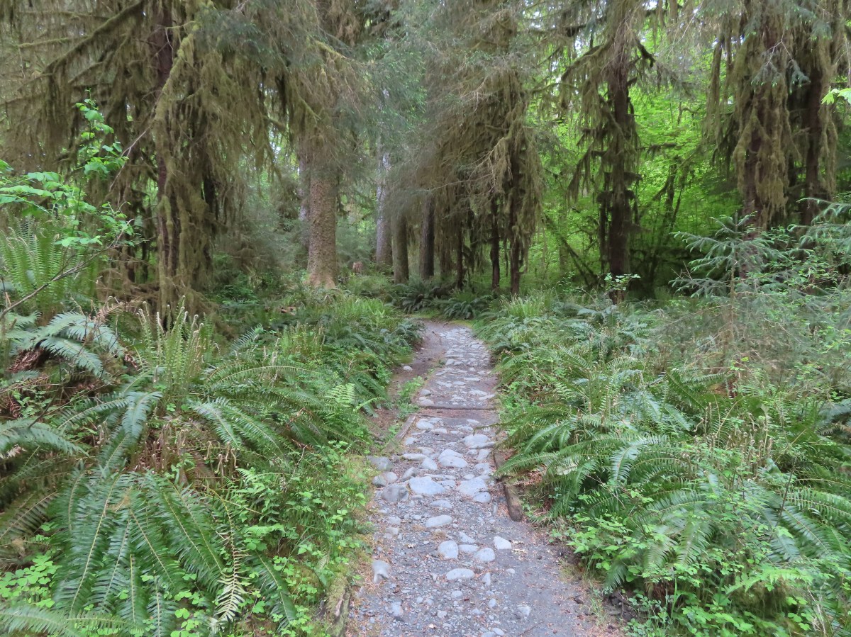
We forked right onto the Cape Alava Trail. This 3.1-mile trail led through a coastal forest to the beach near Cape Alava. Much of the trail consisted of boardwalk.

 Bunchberry

 Slug on a skunk cabbage leaf.
 Skunk cabbage

 Bog laurel along the trail.
 Closer look at the bog laurel blossoms.
 Squirrel

 First view of the ocean.

 Beach bunny
 Ozette Island. The signpost is used to identify inland trails that bypass the beach.
At the beach we turned left (south) and began walking along the rocky beach.
 Bodelteh Islands
 Heading south along the beach.
 We had heard sea lions somewhere in the direction of Ozette Island as we were approaching the beach.
 There is a seal in the foreground and a couple of sea lions on the rocks beyond.
 Seals lounging on the rocks.
This beach hike wasn’t quite as challenging as the previous day on Rialto Beach (post) but there was a lot of slick ocean vegetation that was washed up on the shore.

 One of several campsites along the beach.


 Approaching Wedding Rocks. There is a bypass sign ahead if you look closely. At higher tides it is not possible to go around the rocks along the beach.
 A couple of crabs taking a defensive position as we were passing by.
 Wedding Rocks
 On the other side of the Wedding Rocks. As I mentioned before this is where the petroglyphs are, but we’d already forgotten to be looking for them. In Heather’s defense she had started to come down with a cold the previous day and was not feeling 100%. I however had no excuse.
Beyond the Wedding Rocks we had to cross a rocky area where there were many pools.


After reaching some sand we took a break on a log before continuing on.
 Looking back at the Wedding Rocks.
 Robin
Robin
 Bald eagle
 Whimbrel
 Hole in a sea stack.

 Seals and cormorants

 The second rocky headland where there was an inland bypass route. On the far side is where we ran into the hiker who thought these were the Wedding Rocks where he’d seen the petroglyphs before.
 Path through the rocks. It made sense to us that this would be where the petroglyphs were given there were several passages between the rocks here.
 Coming out the other side.
 Looking back at the rocks that weren’t the Wedding Rocks.
After hiking back to the rocks with the hiker to look for the petroglyphs, which he did have photos of on his phone, we continued south to Sand Point. Along this stretch we passed a couple of large groups of backpackers heading north.
 Sandpoint ahead.
 Semipalmated plover
There was a use trail up the headland at Sand Point which I felt obliged to go up.

 View south
 One of the groups of backpackers heading north from Sand Point.
 Chickweed on the headland.
We picked up a trail in the trees near some empty campsites and followed it inland along Sand Point.

There was a bit of a maze of use trails in the trees but we eventually found some trail signs and picked up the Sand Point Trail that would lead us back to Ozette Lake.


Similar to the Cape Alava Trail this trail had lot of boardwalk sections over the muddy forest floor.

 Evergreen huckleberry blossoms.
 Bench along the trail.
 Groundcone. Heather had a sharp eye to pick this up on the forest floor.

 There were a couple of missing sections of boardwalk along this side of the triangle.
 Ozette Lake
This hike came in at an even 10-miles. Wandering around looking for the petroglyphs and going to the end of Sand Point instead of cutting up off the beach at the signed bypass added a little distance to the typical 9.4-mile distance.

Heather was a trooper for getting through this hike with what had now become a pretty intense cold. The cold would however keep her from our final hike and as I am writing this trip report I am dealing with the same illness. It had sprinkled off and on near the end of this hike and more rain was on the way Friday. For now we headed back to Forks and after changing clothes headed to Sully’s Drive-In for some burgers and tater tots before turning in for the night. Happy Trails!
Flickr: Ozette Triangle


 James and Little James Islands
 The beach was mostly small pebbles to start. Our steps often sunk more than expecting requiring more effort than we’d have guessed. We spent quite a bit of time trying to find the most solid ground.
 Our footsteps on the beach.
 Stump in the sand.
 Ellen Creek. The creek flowed under the beach and emerged shortly before the ocean.
 Seagull
 Bald eagle


 Looking back through the arch.


 This racoon was searching the tide pools for breakfast.
 Looking back toward Hole-in-the-Wall.

 Many of the dark spots on these rocks are the small crabs.
 Does anyone know what this is?

 Oyster catcher
 Cormorants
 Cape Johnson in the distance.
 Paintbrush
 Unnamed creek not quite making it to the ocean above ground.
 Cape Johnson

 I turned around at the slide ahead.
 Hermit crab shells
 A good example of the challenging terrain.
 Seagull, oyster catchers, and a cormorant.
 Paintbrush on the cliffs above the beach.
 Hole-in-the-Wall and James Island back in view.
 Not a great picture due to the extreme zoom and low lighting. After looking closer at this photo I began thinking it was just a rock in the surf. Then I looked at the next photo and what would be the foot and the head were in different positions.
 Possible sea otter.
 The area around Hole-in-the-Wall was a lot busier on the way back.
 Driftwood on the beach.
 Heather spotted this little starfish while exploring the tide pools near the arch.
 Heather also spotted this which we believe is a velella velella.
 Starfish and anemones
 Bald eagels
 On the jetty looking at James Island.
 La Push across the river.
 Sea lion in the river.
 Heading back to the trailhead along the jetty.
 The jetty is actually part of the Quileute Indian Reservation.

 Map of the area trails at the trailhead.
 Anyone know why the spelling on the sign is different?
 Violets
 Bridge over an unnamed creek.
 Trillium
 Coltsfoot
 Fairy bells


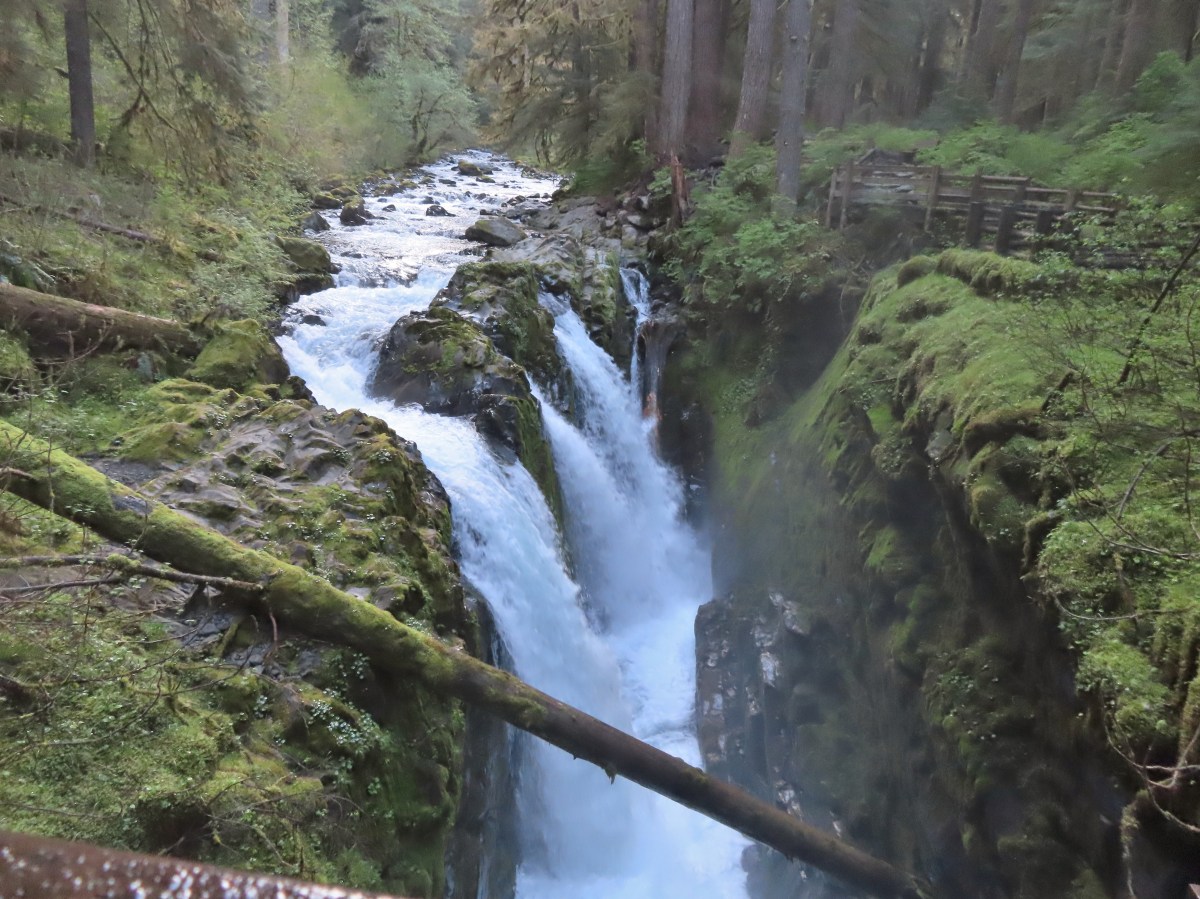
 Depending on the volume of water there are up to four channels which was the situation on this day.
 Heather on the bridge above the falls.


 Storm King Ranger Station
 Forget-me-nots (non-native) along the trail.
 Lake Crescent

 Storm King Trail to the left.
 Marymere Falls Trail junction with the Barnes Creek Trail.
 Footbridge over Barnes Creek.
 Barnes Creek
 Trillium
 Footbridge over Falls Creek almost immediately after crossing Barnes Creek.
 Falls Creek
 Start of the clockwise loop.

 Marymere Falls
 The trail climbing up from the first viewpoint.
 Marymere Falls from the second viewpoint.
 Final viewpoint before the loop curved away from the falls and descended back to its start.
 The footbridges over the two creeks.
 Unnamed fall on Falls Creek from the footbridge.
 It was now almost 9am so there were a few cars parked here already.

 Various poems were located along the first mile of the trail.
 This trail is open to a variety of users.
 Haiku
Haiku

 A second haiku.
 Common whipplea
 Starflower
 Valerian
 Clear water in Lake Crescent.
 Paintbrush
 Something in the pea family.
 Nearing Devil’s Punchbowl.
 Devil’s Punchbowl
 There was a fair amount of poison oak along the trail to Devil’s Punchbowl.
 Madrones
 Honeysuckle
 Common cryptantha
 Rejoining the railroad trail on the far side of the tunnel.
 Butterfly
 Another type of trail user.
 View west.
 View east.
 Big deervetch
 Fairy slippers
 Chipmunk
 Woodpecker
 Lake Crescent Lodge on the far side of the lake.
 Squirrel
 Wallflower
 The second tunnel.
 Thimbleberry
 White crowned sparrow
 Going through the tunnel.
 I went a little further around this bend while Heather took a seat on a log after exiting the tunnel.
 Paintbrush
 View across the lake toward the Barnes Creek Valley.
 I believe the snowiest peak is Lizard Head Peak.
 Saxifrage
 Chickweed
 Swallow
 Oregon sunshine
 Lupine
 Stonecrop
 Variable-leaf collomia

 This was a longer tunnel and had little light near the middle.
 Descending to the trailhead.

 The lake from the picnic table.
 Common loon
 These mallards came flying in then waddled up to see if they could scrounge something from us, but we explained that we do not feed the wildlife (
 Stellar’s jay
 Trying to find the route to the lodge.
 Mushroom
 The lodge is just on the other side.


 Interpretive signs explaining the creation of Lake Crescent by glaciers.
 This trail had good signage unlike the area near Bovee’s Meadow.

 Chair near the lodge.
 Lake Crescent Lodge.


 Hall of Mosses pointer.
 Spring fed Taft Creek.
 Start of the one-way loop.
 Interpretive sign along the loop.
 Looking up from the interpretive sign.
 Maple Grove
 Nursery log

 Fallen sign for the Spruce Nature Trail.

 This was another interpretive loop.
 Hoh River from the trail.
 This huge root ball was hosting its own mini forest.
 Taft Creek
 The trail extends all the way up to Glacier Meadows below Mt. Olympus.
 Violet
 Fungi
Fungi
 Another type of violet.
 Hoh River
 Bunchberry and strawberry bramble
 Slug
Slug Trillium
 Squirrel
 One of the “ups”.
 Star flower
 Hoh River
 Mineral Creek
 Scouler’s corydalis along Mineral Creek.
 Mineral Creek Falls
 Unnamed creek a short distance beyond Mineral Creek.
 Waterfall on the unnamed creek.
 Sign for the spur trail to Mount Tom Creek Camp.
 Wren
Wren
 Vanilla leaf
 Water droplet on a vanilla leaf.
 More violets
 Salmonberry along the trail.
 Big leaf maple canopy.
 There were a few obstacles such as this closer to 5 Mile Island.
 Cougar Creek crossing.
 Marker at the spur trail for 5 Mile Island Camp.
 Hoh River at 5 Mile Island Camp.
 View upriver from the same spot.
 Privy at 5 Mile Island Camp.
 Crow
Crow Cat Peak, Mount Carrie, and Ruth Peak partly under clouds.
 Cat Peak
 We saw a lot of robins, on this hike and the over the next four days.
 Slug
Slug
 Candy flower
 Almost back to the trailhead.

 There were a couple of downed trees and at least one spot where part of the tread had given way on the hillside. A bigger issue was the broken glass and other garbage left by mouth breathers that was littered about.
 It was just over a third of a mile to the falls.
 Beaver Creek below the falls.
 Trail snail
 Fringecup
 Starflower


 Fairy lanterns
 Scouler’s corydalis
 Bleeding heart
 False lily of the valley
 Highway 30 crossing.
 Sign along the section of trail between the highway and the fish hatchery.
 Trail pointer on the shelter at the fish hatchery.
 Youth-on-age
 Numbering on a tree for the interpretive trails.

 Bigfoot off the Gnat Creek Trail.
 Trillium
 Huckleberry blossoms and a downed tree along the Gnat Creek Trail.
 Scouler’s corydalis along the trail.
 The start of the short loop.
 One of two benches along the loop.
 Gnat Creek from the bench.
 The backside of the loop was a little overgrown.
 Star-flowered Solomonseal
 We mostly stayed right at junctions to keep along the creek.

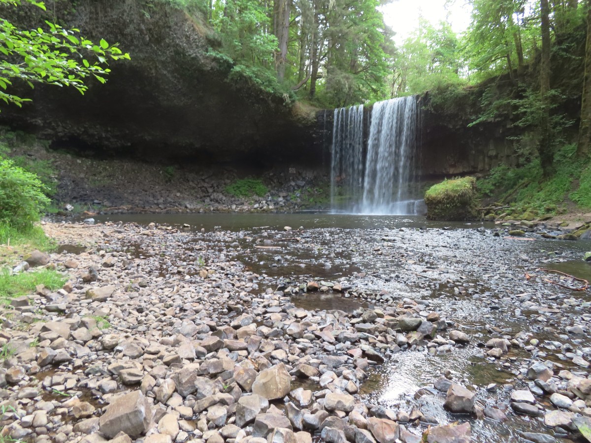
 Barrier Falls

 Unnamed waterfall near the hatchery trailhead.


 Mill Creek from the bridge.
 Stellar’s jay
 Chipmunk
 Loon Lake
 The lake was formed by a landslide. The boulders in the Mill Creek picture above were part of that landslide.
 Trillium
 This was our first hike in the Elliott State Forest and possibly only hike given the forest webpage states under “There are no established trails, restrooms, or trash receptacles.”
 Fairy lanterns
 Given that the unnamed stream that feeds the waterfall appears to start just a bit further uphill I suspect it doesn’t often have much of a flow, but it was a decent waterfall in a lovely setting.
 A very short path led down to the waterfall.
 Camp Creek Falls. The rock here is sandstone which creates the 31′ stairstep cascade.
 Snail
Snail Before reaching Highway 38 I had to pull over to get a couple of photos of an elk herd.


 Camas
Camas Not sure why this was lying on the side of the trail away from the trailhead, but it provides information on the seasonal allowed usage of the units.
 Geese
Geese
 Roses
Roses Channel along the dikes.


 Rough-skinned newt
 Slug
Slug Snail
Snail Made it out.


 Bench along Coyote Creek

 I should have gone this direction. The presence of the bench should have tipped me off.
 Overgrown but in the right spot.
 The orange section is where I turned right instead of left as I should have. I estimate that going the correct way would have added approximately 0.75-miles. I don’t know what type of condition the other section of trail through the woods is in.

 Road to Fisher Butte,
 Camas
Camas Bird viewing platfrom.
 Red-winged blackbird
 Bullfrog. They were everywhere and continuously startled us when they would make a loud “alarm” sound before jumping into the water.
 We turned left at the platform onto this dike.
 Sparrow
 Blue-winged teals. This was the first time seeing this species during Wildlife Week. We had seen a couple of these ducks back in 2021 at Cold Springs National Wildlife Refuge in Eastern Oregon (
 Another big field of camas.
 Fisher Butte at the end of another dike.
 Geese in formation.
 Checkerbloom
 Blue sky, a far cry from the low clouds and showers we’d driven through in the Eugene area earlier in the morning.
 Geese and cinnamon teals.
 I needed a more powerful camera to make out the various ducks and other birds we were seeing in the distance.
 There were a number of great blue herons hunting in the wetlands.
 Another viewing platfrom.
 Looking toward the Royal Avenue Unit.
 Pelicans. Another species that I hadn’t seen at any other wildlife area this week.
 Purple martin
 One of at least a half dozen American bitterns that we saw in flight. We were unable to spot any before or after they were in flight.
 Swallows in flight
 There was a lot happening in this part of the unit.
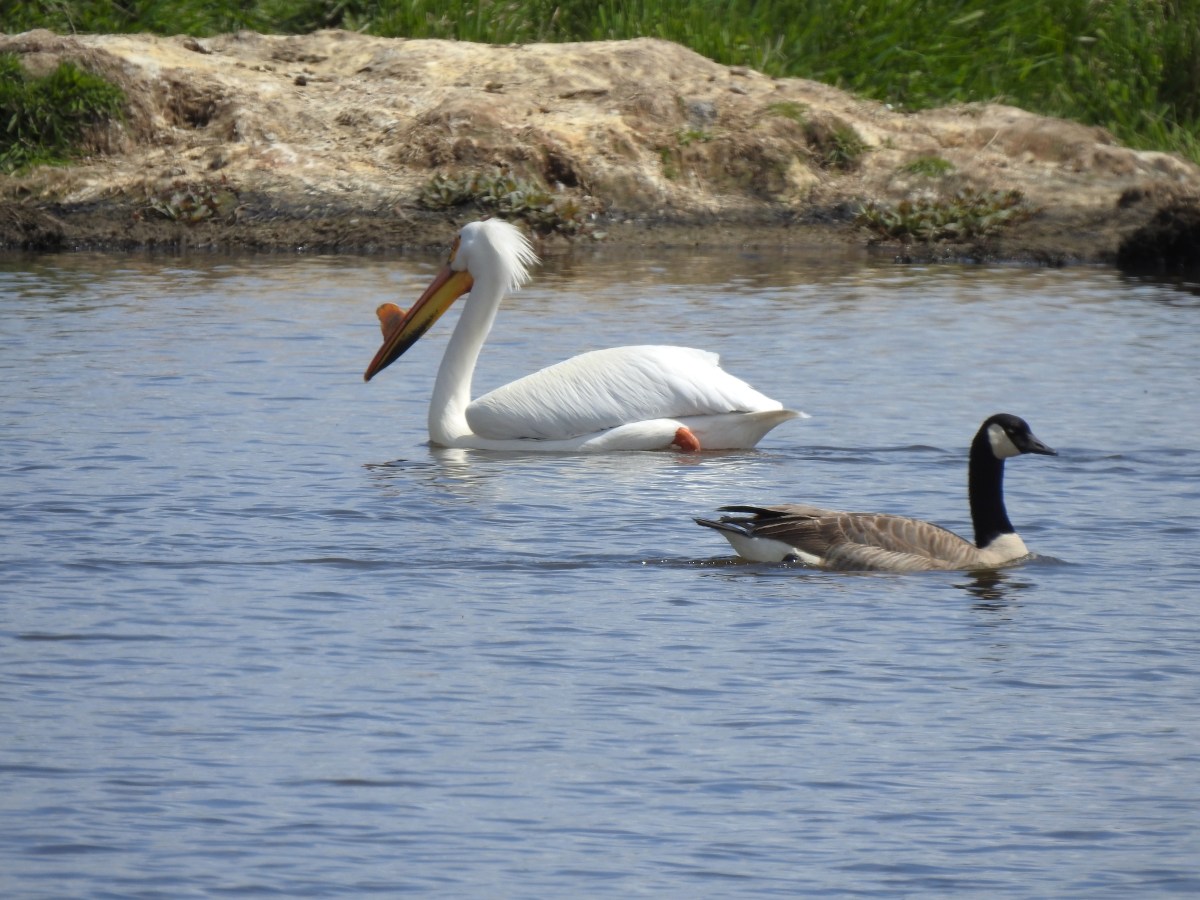
 White pelicans and a mute swan (non-native)
 Geese
Geese Another first this week – greater white fronted geese. It’s a blurry photo but it was the best I could do given their distance.
 Goose passing the swan.
 Same goose passing a pelican.
 Northern shoveler
 Hawk
Hawk Another large group of various ducks and other birds.
 Bald eagles
 Two types of camas
 Heading back to the trailhead along the side of Fisher Butte.
 Flax
Flax The final stretch of Wildlife Week.

 All trails are open from February 1st through September 30th, then from October 1st through November 30th the final 1.3-mile stretch to the right (south) is closed, and there is no hiking allowed during hunting season from December 1st to January 31st.
 Geese
Geese Osprey
 Killdeer
 Meadow checker-mallow
 Wood ducks
 Northern shovelers
 Ducks, geese, and a heron.
 Scrunched heron
 Stretched heron (same heron)
 Sparrow
 A different heron and a duck.
 Yep, it’s a nutria.
 Spotted sandpiper
 One of several benches located along the dikes.
 American coot
 Gadwall
 Dove
Dove Crow
Crow American kestrel
 Swallow
 Cinnamon teals having a disagreement.
 End of the trail to the south.
 View from the end of the trail.
 Wood ducks
 Robin
Robin Short billed dowitchers
 Green winged teal
 Hooded merganser and a gadwall
 Ring-necked ducks
 Heading to the left (NNE) now.
 Red-winged blackbird
 Egrets, herons, and ducks.
 Great blue heron and egret
 Cinnamon teal and northern shoveler
 Hooded mergansers and a cinnamon teal
 Northern shovelers and a northern pintail on the right.
 California quail
 End of the trail in this direction.
 My 3.3-mile track with minimal elevation gain.
 Swallow
 Osprey
 Killdeer
 American coot
 Mallard
 Anna’s hummingbird
 A bit of the pink on it’s throat.
 Ring-necked ducks
 Bald eagle
 Gadwalls
 Song sparrow
 Purple martins
 Pied billed grebe
 Mallard and ducklings
 Mallards
 Fringecup
 Rabbit
 Sandpipers
 Ground squirrel
 American goldfinch. I’d seen a number of these this week but had only managed a picture of the back of one at Finley Wildlife Refuge.

 The orange track is a portion of the Wetland Trail that I had not previously hiked.
 Mt. Hood from the Wetlands Trail.
 I spotted a couple of deer shortly after setting out.

 I believe this is a savannah sparrow.
 Geese families
 Killdeer
 It was just under 40 degrees Fahrenheit when I started, but the forecast called for temperatures to reach 80 by the afternoon.
 Geese, goslings, and goose eggs.
 Sandpiper
 Not sure what type of fish this is but they were thrashing about near the shoreline, and I had seen similar behavior the day before in McFadden Marsh at Finley NWR.
 Duck and ducklings
 Sleeping nutria
 Purple martins and a swallow (bottom left).
 Egrets and a great blue heron.
 Closer look at the egrets and heron.
 Robin
Robin


 Mallard
 Sandpipers
 Riverside Trail
 Tualatin River
 Song sparrow
 Inside-out flower
 The Ridgetop Trail to the left. There is a bench and railed overlook but the view is blocked by trees. If there hadn’t been any leaves there may have been a view but today there wasn’t.
 The only trillium I saw with any petals left.
 Bleeding heart
 Northern flicker
 I spotted an American kestrel in this snag. I had been hoping to see one during this week’s hikes.
 American kestrel
 Crow
Crow Northern shoveler
 Wildflowers near the trailhead.
 Lupine, plectritis, checkerbloom, and golden paintbrush.
 This route came to 4.4-miles and just 35′ of elevation gain.
 Camas
Camas
 Larkspur
 Not a native wildflower but pretty.
 Columbine
 Rabbit
 The look on their faces seems to indicate they were not expecting to see me there.
 Going back the other way.
 Karaoke
 Helpful maps and/or pointers are located at trail junctions.
 Swallow
 Swallows
 Cinnamon Teal
 Ring-necked ducks
 Purple martins
 Canada geese
 Jackson Bottom Wetlands Trail passing Oak Island Marsh.
 Crow harassing an osprey over Oak Island Marsh.
 I thought flamingos were pink.
 American coot in NW Pond.
 Another napping nutria.
 Robin
Robin Gadwall
 Egrets at Wapato Marsh.
 Great blue heron in Pintail Pond.
 Lupine along the trail.
 Green winged teal
 Heading toward Salamander Slough.
 Two turtles and a mallard.
 Long billed dowitcher
 Cabbage white?
 Checkerbloom along the Coyote Hill Trail.
 Common yellowthroat
 Savannah sparrow
 Spotted towhee
 Tualatin River
 Deer crossing Pintail Pond. I think these are the same three I saw earlier.
 I’ve been spotted.
 Rabbit on the left along the River Trail.
 Salmonberry
 Western meadowrue
 Wild rose
 Stairs leading to the trail on the River Trail.
 The orange loop is the Mill Hill Loop.
 The orange section on the right is my detour with the solid cyan representing the 2024 route. (Other colored lines are from the other previous visits.)
 Rabbit
 Sunrise view
 Mt. Jefferson
 I hadn’t gotten very far before I spotted a couple of elk ahead.
 Coyote


 I stopped here not wanting to get any closer and waited to see what the elk would do.
 The lead bull here seemed to have a leadership role because once he emerged and headed across the field the herd followed and then circled up.


 On my 2024 hike I had turned left here on the track at the edge of the photo, but with the elk out there I stayed straight(ish) along the tree line. Apparently that is part of the Prairie Extension Trail, but it was a more obvious path and there was an equally obvious path that angled off the extension trail back to the main Prairie Trail.
 It was a wet muddy hike this time of year.
 Camas and buttercups
 McFadden Marsh sending up a light fog.
 Wood ducks
 Northern shoveler
 Mallards, a green winged teal, a cinnamon teal, and a wood duck.
 Ruddy duck
 I’m sure it’s a nutria, it’s almost always a nutria.
 Cinnamon teals
 Female wood duck
 Bald eagles on the far side of the marsh.
 Blackbird
 Buffleheads
 Great blue heron
 Green winged teals and American wigeons
 Dove
Dove Marsh wren
 Heron hanging out near the Mcfadden Marsh blind.
 Egrets and ducks
 Egrets
 Robin
Robin

 There were actually two bitterns.
 Their camo is so good.
 American coot
 Swallows
 Pied billed grebe
 Ring-necked duck
 Cinnamon teals
 Manroot and the Cheadle Barn
 California scrub jay
 Bittern flying over the Cheadle Barn Pond with Pigeon Butte in the background.
 Iris and golden paintbrush on the side of Pigeon Butte.
 Golden paintbrush and I guess the beetle counts as wildlife.
 Savanah sparrow near the Finger Ponds.
 Geese in a field near the Finger Ponds.
 Turkey vulture
 Goose and goslings in Cabell Marsh.
 Great blue heron at Cabell Marsh.
 American goldfinch near Cabell Marsh.
 California quail near Cattail Pond.
 Pied billed grebe at Cattail Pond.
 Camas along the Cattail Pond Trail.
 Pacific waterleaf along the Beaver Pond Trail.
 Checker lily along the Beaver Pond Trail.
 Fairy lanterns along the Beaver Pond Trail.
 Giant white wake-robin along the Beaver Pond Trail.
 Bullfrogs and blackbirds were all I saw at the Beaver Pond.
 Turkeys along the Beaver Pond Trail near Park Headquarters.
 The start and end of the Mill Hill Loop.
 Yellow violets in the midst of invasive herb robert.
 Bleeding heart
 Gray squirrel
 Star flower
 Spotted coralroot
 I’d once spotted a turtle on this log in a pond below the Mill Hill Loop so I took a picture hoping for another one. Instead I got a bullfrog.
 Mallards in the same pond.
 Solomonseal
 Tolmie’s mariposa lily
 The forest is pretty along the Mill Hill Loop.
 Poet’s shooting star
 Small-flowered woodland-star
 The end and start of the Mill Hill Loop.
 Tough-leaved iris
 There were a bunch of bullfrogs sunning at the little pond along the Woodpecker Loop.
 Lomatium on the Woodpecker Loop.
 Woodpecker Loop Overlook. I took a break on the bench here and changed into dry socks after having a snack.
 This northern harrier was putting on an aerial display while I took my break.
 Wildflowers along Bald Hill.
 Wild rose
 Checkerbloom
 Tough-leaved iris and golden paintbrush
 More turkeys along Finley Refuge Road.

 Cabell Barn across from the entrance road to the Cabell Marsh Trail.
 Honeybee swarm along the road to the Cabell Marsh Trail. It looks a little like a heart.
 This end of Cabell Marsh was practically deserted. My guess was that there was plenty of water right now in less visited areas, so the birds were avoiding this area for now.
 You can almost always count on a coot though.
 Cormorants out on a log in the middle of the marsh.
 Homer Campbell Boardwalk
 Wood ducks. These might have been the first significant wildlife I’d seen from the boardwalk. It’s a really neat trail I just rarely see any wildlife from it (with the exception of the shelter).
 Turkey vulture flying over Turtle Flats.
 Turtles at Turtle Flats!


 You can actually see some of the route I explored on the left side between Parvipes Marsh and the butte and at the bottom of the picture wrapping around the butte.
 Manroot
 Camas
Camas Plectritis
 Checkerbloom
 Tolmie’s mariposa lilies


 Morgan Lake with a bit of Moffitti Marsh to the left.
 Columbine
 Iris
Iris
 Robin
Robin Sparrows
 Gold crowned sparrow
 The grass was low enough that the lake was fairly visible. Later in Spring you’re lucky to see any water from the trail.
 Not a great picture due to the distance and light, but there are a couple of ruddy ducks to the left hanging out with some ring-necked ducks.
 Mallards
 American coot
 Gadwalls
 Buffleheads
 Common yellowthroat
 Looking for a bittern.
 American bittern. I could only see the bittern from a very short section of trail and as soon as I lost a little elevation it disappeared from sight. It never flew off, but I couldn’t see it even knowing where it was.
 Following the trail next to Smithfield Road.
 Lots of red-winged blackbirds near the trailhead.
 Finch
Finch Heading back toward Baskett Butte and Moffitti Marsh.
 Northern flicker
 Moffitti Marsh
 American wigeons
 Female common yellowthroat
 Spotted towhee
 I watched a crow chase off a hawk that had apparently gotten too close.
 The official trail heads up the hill to the left. I veered right just beyond the trail sign pointing toward Moffitti Marsh.
 Lilac
Lilac Parvipes Marsh ahead to the right.
 The tractor turned right and drove over a dike at the end of Parvipes Marsh to a field on the other side.
 Deer farther up the hillside.

 This appears to be balsamroot. There were just a couple of patches on the SW side of the butte.
 Cottonwood Pond
 Buttercups and miniature lupine
 Meadow checker-mallow
 Lomatium and plectritis
 South Slough Pond
 I was a bit surprised to find a bench along this route given it isn’t shown as an official trail.
 Grass pea
 More checkerbloom
 Golden paintbrush
 If I hadn’t been looking for the tread I don’t think I would have noticed it.
 Lupine
 Another Tolmie’s mariposa lily
 Western meadowlark
 The overlook ahead.
 The obligatory photo from the overlook.
 Lots of patches of plectritis on the butte.
 Ground squirrel
 Swallow
 Baskett Butte from the Cottonwood Pond parking area.
 Mallards
 Northern pintails
 Northern shovelers
 Lesser scaup. They look a lot like ring-necked ducks only without the ring.
 Ring-necked ducks
 Nap Time.