We spent Memorial Day weekend in The Dalles in order to cross a few “to-dos” off our hiking list. Our first stop was a two-for-one hike in the Badger Creek Wilderness. The plan was to make a loop out of the School Canyon and Little Badger Trails which would allow us to cross those trails off the list of hikes we still hadn’t done featured in our Matt Reeder guidebooks (Off the Beaten Trail). The School Canyon Trail is featured in his “PDX Hiking 365” (1st edition) and The Little Badger Trail is covered in “Off the Beaten Trail” (2nd edition).
The two trailheads are 3.5 road miles apart but only about a half mile separates them in a direct line. Both Reeder and the entry in the Oregon Hikers Field Guide mention avoiding the longer road walk by cutting cross country suggesting slightly different routes and having differing opinions on difficulty. Based on the two hike descriptions and a recent discussion in the Oregon Hikers Forum it appeared to me that the “best” solution was to bushwack downhill from Forest Road 27 to the Little Badger Trailhead roughly a half mile from the School Canyon Trailhead. I arrived at this conclusion based on our belief that going down is easier than climbing up and by comparing Google Earth imagery with a topographic map. I was looking for the least steep looking open hillside which would limit the number of downed trees we might encounter. Prior to leaving I added waypoints to our GPS units to mark where I thought we should leave the road and one at the Little Badger Trailhead so we could easily see what we were aiming for.
We left Salem extra early and arrived at the School Canyon Trailhead about a quarter after seven.

From the trailhead we headed left (SE) on FR 27 until we reached the waypoint I had created then looked for an open spot to start the cross-country portion of the hike.

 We headed off through the trees here.
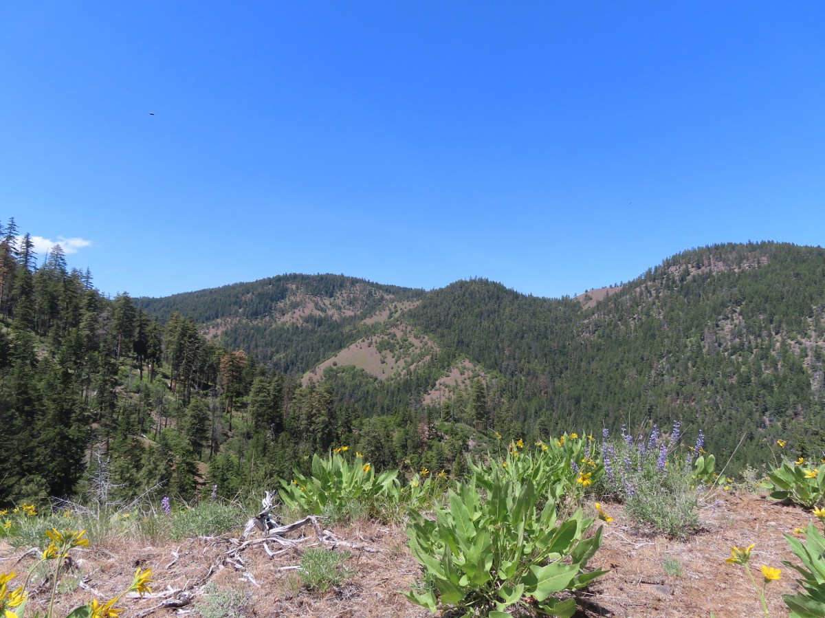
After passing through a small stand of trees the views opened up to the SW where Mt. Jefferson and Olallie Butte stood out on the horizon.

 Mt. Jefferson and Olallie Butte (post).
 Gordon Butte in the foreground.
Our route steepened as we headed downhill among a number of different wildflowers.
 Balsamroot and oak trees.
 Buckwheat and balsamroot
 Whitestem frasera with Mt. Jefferson in the background.
 Rough eyelashweed
 Paintbrush
 We picked up a faint path, not sure if it was a game or use trail.
As we neared the Little Badger Trailhead we entered another stand of trees.

 Lupine and ponderosa pines.
We popped out of the trees on FR 2710 less than 20 yards from the Little Badger Trail.

 The trailhead is on the opposite side of FR 2710 from the trail.
 Sign at the start of the Little Badger Trail.
After the half mile road walk and 0.6-miles cross country we were now on official trail and quickly entered the Badger Creek Wilderness.
 Badger Creek Wilderness sign next to Little Badger Creek.
For the first two miles the trail stuck closely to the creek.

 Groundsel
 Woodland stars
 Little Badger Creek
 Fairy slipper
The trail then climbed a little higher on the hillside as it continued further into the wilderness.

 American vetch

 Bastard toadflax
 Duskywing on sagebrush false dandelion.

 Balsamroot
 Bee coming in for a landing on phacelia.
 Sticky cinquefoil
 Western wood-pewee
 Madia
Madia
 Brown elfin (and another pollinator) on Oregon sunshine.
 Starflower
 Mahala mat along the trail.
 Duskywing on blue-eyed Mary
 Largeleaf sandwort along the trail.
 Skunk cabbage
 Red-flowering currant
 Duskywing on arnica

 Silvercrown
 Oregon grape
 Last of the trillium.
 Plumed solomonseal
The trail had begun a descent back to the creek at the 3-mile mark and just under 4-miles from the trailhead we arrived at the site of the former Kinzel Mine Cabin.

 What’s left of the cabin.
 Little Badger Creek at the cabin site.
We took a brief break at the cabin to prepare for the nearly 900′ climb to reach the School Canyon Trail. After the break we walked past the cabin remains and forked left to visit the old Kinzel Mine.
 Anemone
 There was a short climb before reaching the spur trail.
 Spur trail to the mine.
 The old mine. We did not go in as wildlife do sometimes use it for shelter.
 Ballhead waterleaf near the mine.
After visiting the mine we returned to the main trail and began the steep 0.7-mile climb to the School Canyon Trail. This was a challengingly steep ascent, but there were plenty of wildflowers, wildlife, and views to distract us.

 Western tanager
 A stand of oaks ahead.
 Balsamroot along the trail.
 Paintbrush
 Buckwheat
 Juniper trees
 Threadleaf phacelia


 Signpost ahead for the trail junction.
We took a much-needed break at the junction before detouring left (west) on the School Canyon Trail for a tenth of a mile to a spur trail on the left that led to a Helispot Viewpoint where there were several rock pinnacles.

 Wildflowers along the trail.
 The spur trail on the left to the Helispot.

 Penstemon


 Pine Hollow Reservoir in Central Oregon.
We returned to the junction after visiting the helispot and followed the School Canyon Trail as it gradually descended to a ridge below Ball Point.


 Woodland star
 This was the most significant obstacle we had to navigate on the entire loop.
 Yarrow
 A dogwood on top of the rocks and penstemon below.
 First view of Ball Point.
 Penstemon
 From the ridge we could faintly make out Broken Top and the Three Sisters.
 The Three Sisters on the right and Broken Top with Tam McArthur Rim (post) to the left.
 Pen Point across the Tygh Creek Valley.
The trail left the ridge and traversed the hillside around Ball Point.
 Passing through the 2009 Ball Point Fire scar.

 Pen Point toward the center and the taller Hootnanny Point to the right.
 Death camas
 View east as we came around Ball Point.
 Desert yellow fleabane.
 Prairie smoke aka Old Man’s Whiskers
On the far side of Ball Point the trail descended fairly steeply along a ridge covered in wildflowers and a view of Mt. Jefferson.


 Heather coming down the ridge.
 I think this is a western racer.
The trail dropped off the ridge and descended just over a mile to the trailhead. The wildflowers and views were nice along this entire stretch.
 Looking up at the ridge.
 A clarkia
 Lewis’ woodpecker
 Lizard


 On last view of Mt. Jefferson
 Ball Point
 Butterfly on whitestem frasera
 Signs at the trailhead.
The loop ended up being 9.9-miles with 2150′ of elevation gain.
 Orange is the road + cross country portion.
We really enjoyed the variety this hike provided, and we only saw two other hikers all day. The climb from the cabin site to the School Canyon trail was tough but we were glad to have tackled it. We checked in to our room in The Dalles and after having dinner and picking up some snacks for the room we turned in so we could get another early start the following day. Happy Trails!
Flickr: School Canyon-Little Badger Loop

 This trail is part of the
 Damaged footbridge over Morganroth Creek at the 0.2-mile mark.
 The Wetland Loop Trail split off just beyond Morganroth Creek. I stayed right and planned on returning via the loop.
 This was a muddy trail which isn’t surprising for an area that receives 120″ of rain (3 meters) on average annually.
 Youth-on-Age
 Approaching the Bogachiel River.
 Bogachiel River
 The other end of the Wetland Loop was approximately a half mile from the Olympic National Park boundary.
 Kahkwa Creek. The log down in the distance was crossable but I opted to ford the creek on my first pass.
 Ford at Kahkwa Creek.
 Signs at the park boundary. The trail name changes here to the Bogachiel River Trail.
 Wilderness permits for back country camping. At this point I was not only in the park but also the

 The dry creek where I turned around.
 The log crossing over Kahkwa Creek.
 The Wetland Loop Trail junction was near the Kahkwa Creek crossing.
 The Wetland Loop began along Kahkwa Creek.

 Skunk cabbage
 The Wetland Loop traversed up and down along a hillside above some wetlands.
 Scouler’s corydalis
 Wetlands below the loop trail.
 Completing the loop.
 Fairy lanterns


 Notice regarding the petroglyphs on Wedding Rocks. By the time we were on the beach we’d completely forgot to look for these. We did run into another hiker who had seen them on a prior trip, but he couldn’t remember where. He thought they were located at some rocks near where we’d run into him, so we searched those rocks for several minutes with no luck. As it turns out he was mistaken as to where Wedding Rocks was, it is located on the first rocky headland nearest Cape Alava at the northern end of the triangle hike. We were much closer to the southern end.
 Ozette River leaving Ozette Lake.

 Bunchberry
 Slug on a skunk cabbage leaf.
 Skunk cabbage
 Bog laurel along the trail.
 Closer look at the bog laurel blossoms.
 Squirrel
 First view of the ocean.
 Beach bunny
 Ozette Island. The signpost is used to identify inland trails that bypass the beach.
 Bodelteh Islands
 Heading south along the beach.
 We had heard sea lions somewhere in the direction of Ozette Island as we were approaching the beach.
 There is a seal in the foreground and a couple of sea lions on the rocks beyond.
 Seals lounging on the rocks.
 One of several campsites along the beach.

 Approaching Wedding Rocks. There is a bypass sign ahead if you look closely. At higher tides it is not possible to go around the rocks along the beach.
 A couple of crabs taking a defensive position as we were passing by.
 Wedding Rocks
 On the other side of the Wedding Rocks. As I mentioned before this is where the petroglyphs are, but we’d already forgotten to be looking for them. In Heather’s defense she had started to come down with a cold the previous day and was not feeling 100%. I however had no excuse.

 Looking back at the Wedding Rocks.
 Robin
Robin Bald eagle
 Whimbrel
 Hole in a sea stack.
 Seals and cormorants
 The second rocky headland where there was an inland bypass route. On the far side is where we ran into the hiker who thought these were the Wedding Rocks where he’d seen the petroglyphs before.
 Path through the rocks. It made sense to us that this would be where the petroglyphs were given there were several passages between the rocks here.
 Coming out the other side.
 Looking back at the rocks that weren’t the Wedding Rocks.
 Sandpoint ahead.
 Semipalmated plover
 View south
 One of the groups of backpackers heading north from Sand Point.
 Chickweed on the headland.


 Evergreen huckleberry blossoms.
 Bench along the trail.
 Groundcone. Heather had a sharp eye to pick this up on the forest floor.
 There were a couple of missing sections of boardwalk along this side of the triangle.
 Ozette Lake


 James and Little James Islands
 The beach was mostly small pebbles to start. Our steps often sunk more than expecting requiring more effort than we’d have guessed. We spent quite a bit of time trying to find the most solid ground.
 Our footsteps on the beach.
 Stump in the sand.
 Ellen Creek. The creek flowed under the beach and emerged shortly before the ocean.
 Seagull
 Bald eagle


 Looking back through the arch.


 This racoon was searching the tide pools for breakfast.
 Looking back toward Hole-in-the-Wall.

 Many of the dark spots on these rocks are the small crabs.
 Does anyone know what this is?

 Oyster catcher
 Cormorants
 Cape Johnson in the distance.
 Paintbrush
 Unnamed creek not quite making it to the ocean above ground.
 Cape Johnson

 I turned around at the slide ahead.
 Hermit crab shells
 A good example of the challenging terrain.
 Seagull, oyster catchers, and a cormorant.
 Paintbrush on the cliffs above the beach.
 Hole-in-the-Wall and James Island back in view.
 Not a great picture due to the extreme zoom and low lighting. After looking closer at this photo I began thinking it was just a rock in the surf. Then I looked at the next photo and what would be the foot and the head were in different positions.
 Possible sea otter.
 The area around Hole-in-the-Wall was a lot busier on the way back.
 Driftwood on the beach.
 Heather spotted this little starfish while exploring the tide pools near the arch.
 Heather also spotted this which we believe is a velella velella.
 Starfish and anemones
 Bald eagels
 On the jetty looking at James Island.
 La Push across the river.
 Sea lion in the river.
 Heading back to the trailhead along the jetty.
 The jetty is actually part of the Quileute Indian Reservation.

 Map of the area trails at the trailhead.
 Anyone know why the spelling on the sign is different?
 Violets
 Bridge over an unnamed creek.
 Trillium
 Coltsfoot
 Fairy bells


 Depending on the volume of water there are up to four channels which was the situation on this day.
 Heather on the bridge above the falls.


 Storm King Ranger Station
 Forget-me-nots (non-native) along the trail.
 Lake Crescent

 Storm King Trail to the left.
 Marymere Falls Trail junction with the Barnes Creek Trail.
 Footbridge over Barnes Creek.
 Barnes Creek
 Trillium
 Footbridge over Falls Creek almost immediately after crossing Barnes Creek.
 Falls Creek
 Start of the clockwise loop.

 Marymere Falls
 The trail climbing up from the first viewpoint.
 Marymere Falls from the second viewpoint.
 Final viewpoint before the loop curved away from the falls and descended back to its start.
 The footbridges over the two creeks.
 Unnamed fall on Falls Creek from the footbridge.
 It was now almost 9am so there were a few cars parked here already.

 Various poems were located along the first mile of the trail.
 This trail is open to a variety of users.
 Haiku
Haiku

 A second haiku.
 Common whipplea
 Starflower
 Valerian
 Clear water in Lake Crescent.
 Paintbrush
 Something in the pea family.
 Nearing Devil’s Punchbowl.
 Devil’s Punchbowl
 There was a fair amount of poison oak along the trail to Devil’s Punchbowl.
 Madrones
 Honeysuckle
 Common cryptantha
 Rejoining the railroad trail on the far side of the tunnel.
 Butterfly
 Another type of trail user.
 View west.
 View east.
 Big deervetch
 Fairy slippers
 Chipmunk
 Woodpecker
 Lake Crescent Lodge on the far side of the lake.
 Squirrel
 Wallflower
 The second tunnel.
 Thimbleberry
 White crowned sparrow
 Going through the tunnel.
 I went a little further around this bend while Heather took a seat on a log after exiting the tunnel.
 Paintbrush
 View across the lake toward the Barnes Creek Valley.
 I believe the snowiest peak is Lizard Head Peak.
 Saxifrage
 Chickweed
 Swallow
 Oregon sunshine
 Lupine
 Stonecrop
 Variable-leaf collomia

 This was a longer tunnel and had little light near the middle.
 Descending to the trailhead.

 The lake from the picnic table.
 Common loon
 These mallards came flying in then waddled up to see if they could scrounge something from us, but we explained that we do not feed the wildlife (
 Stellar’s jay
 Trying to find the route to the lodge.
 Mushroom
 The lodge is just on the other side.


 Interpretive signs explaining the creation of Lake Crescent by glaciers.
 This trail had good signage unlike the area near Bovee’s Meadow.

 Chair near the lodge.
 Lake Crescent Lodge.


 Hall of Mosses pointer.
 Spring fed Taft Creek.
 Start of the one-way loop.
 Interpretive sign along the loop.
 Looking up from the interpretive sign.
 Maple Grove
 Nursery log

 Fallen sign for the Spruce Nature Trail.

 This was another interpretive loop.
 Hoh River from the trail.
 This huge root ball was hosting its own mini forest.
 Taft Creek
 The trail extends all the way up to Glacier Meadows below Mt. Olympus.
 Violet
 Fungi
Fungi
 Another type of violet.
 Hoh River
 Bunchberry and strawberry bramble
 Slug
Slug Trillium
 Squirrel
 One of the “ups”.
 Star flower
 Hoh River
 Mineral Creek
 Scouler’s corydalis along Mineral Creek.
 Mineral Creek Falls
 Unnamed creek a short distance beyond Mineral Creek.
 Waterfall on the unnamed creek.
 Sign for the spur trail to Mount Tom Creek Camp.
 Wren
Wren
 Vanilla leaf
 Water droplet on a vanilla leaf.
 More violets
 Salmonberry along the trail.
 Big leaf maple canopy.
 There were a few obstacles such as this closer to 5 Mile Island.
 Cougar Creek crossing.
 Marker at the spur trail for 5 Mile Island Camp.
 Hoh River at 5 Mile Island Camp.
 View upriver from the same spot.
 Privy at 5 Mile Island Camp.
 Crow
Crow Cat Peak, Mount Carrie, and Ruth Peak partly under clouds.
 Cat Peak
 We saw a lot of robins, on this hike and the over the next four days.
 Slug
Slug
 Candy flower
 Almost back to the trailhead.

 There were a couple of downed trees and at least one spot where part of the tread had given way on the hillside. A bigger issue was the broken glass and other garbage left by mouth breathers that was littered about.
 It was just over a third of a mile to the falls.
 Beaver Creek below the falls.
 Trail snail
 Fringecup
 Starflower


 Fairy lanterns
 Scouler’s corydalis
 Bleeding heart
 False lily of the valley
 Highway 30 crossing.
 Sign along the section of trail between the highway and the fish hatchery.
 Trail pointer on the shelter at the fish hatchery.
 Youth-on-age
 Numbering on a tree for the interpretive trails.

 Bigfoot off the Gnat Creek Trail.
 Trillium
 Huckleberry blossoms and a downed tree along the Gnat Creek Trail.
 Scouler’s corydalis along the trail.
 The start of the short loop.
 One of two benches along the loop.
 Gnat Creek from the bench.
 The backside of the loop was a little overgrown.
 Star-flowered Solomonseal
 We mostly stayed right at junctions to keep along the creek.

 Barrier Falls

 Unnamed waterfall near the hatchery trailhead.


 Mill Creek from the bridge.
 Stellar’s jay
 Chipmunk
 Loon Lake
 The lake was formed by a landslide. The boulders in the Mill Creek picture above were part of that landslide.
 Trillium
 This was our first hike in the Elliott State Forest and possibly only hike given the forest webpage states under “There are no established trails, restrooms, or trash receptacles.”
 Fairy lanterns
 Given that the unnamed stream that feeds the waterfall appears to start just a bit further uphill I suspect it doesn’t often have much of a flow, but it was a decent waterfall in a lovely setting.
 A very short path led down to the waterfall.
 Camp Creek Falls. The rock here is sandstone which creates the 31′ stairstep cascade.
 Snail
Snail Before reaching Highway 38 I had to pull over to get a couple of photos of an elk herd.


 Camas
Camas Not sure why this was lying on the side of the trail away from the trailhead, but it provides information on the seasonal allowed usage of the units.
 Geese
Geese
 Roses
Roses Channel along the dikes.


 Rough-skinned newt
 Slug
Slug Snail
Snail Made it out.


 Bench along Coyote Creek

 I should have gone this direction. The presence of the bench should have tipped me off.
 Overgrown but in the right spot.
 The orange section is where I turned right instead of left as I should have. I estimate that going the correct way would have added approximately 0.75-miles. I don’t know what type of condition the other section of trail through the woods is in.

 Road to Fisher Butte,
 Camas
Camas Bird viewing platfrom.
 Red-winged blackbird
 Bullfrog. They were everywhere and continuously startled us when they would make a loud “alarm” sound before jumping into the water.
 We turned left at the platform onto this dike.
 Sparrow
 Blue-winged teals. This was the first time seeing this species during Wildlife Week. We had seen a couple of these ducks back in 2021 at Cold Springs National Wildlife Refuge in Eastern Oregon (
 Another big field of camas.
 Fisher Butte at the end of another dike.
 Geese in formation.
 Checkerbloom
 Blue sky, a far cry from the low clouds and showers we’d driven through in the Eugene area earlier in the morning.
 Geese and cinnamon teals.
 I needed a more powerful camera to make out the various ducks and other birds we were seeing in the distance.
 There were a number of great blue herons hunting in the wetlands.
 Another viewing platfrom.
 Looking toward the Royal Avenue Unit.
 Pelicans. Another species that I hadn’t seen at any other wildlife area this week.
 Purple martin
 One of at least a half dozen American bitterns that we saw in flight. We were unable to spot any before or after they were in flight.
 Swallows in flight
 There was a lot happening in this part of the unit.
 White pelicans and a mute swan (non-native)
 Geese
Geese Another first this week – greater white fronted geese. It’s a blurry photo but it was the best I could do given their distance.
 Goose passing the swan.
 Same goose passing a pelican.
 Northern shoveler
 Hawk
Hawk Another large group of various ducks and other birds.
 Bald eagles
 Two types of camas
 Heading back to the trailhead along the side of Fisher Butte.
 Flax
Flax The final stretch of Wildlife Week.

 All trails are open from February 1st through September 30th, then from October 1st through November 30th the final 1.3-mile stretch to the right (south) is closed, and there is no hiking allowed during hunting season from December 1st to January 31st.
 Geese
Geese Osprey
 Killdeer
 Meadow checker-mallow
 Wood ducks
 Northern shovelers
 Ducks, geese, and a heron.
 Scrunched heron
 Stretched heron (same heron)
 Sparrow
 A different heron and a duck.
 Yep, it’s a nutria.
 Spotted sandpiper
 One of several benches located along the dikes.
 American coot
 Gadwall
 Dove
Dove Crow
Crow American kestrel
 Swallow
 Cinnamon teals having a disagreement.
 End of the trail to the south.
 View from the end of the trail.
 Wood ducks
 Robin
Robin Short billed dowitchers
 Green winged teal
 Hooded merganser and a gadwall
 Ring-necked ducks
 Heading to the left (NNE) now.
 Red-winged blackbird
 Egrets, herons, and ducks.
 Great blue heron and egret
 Cinnamon teal and northern shoveler
 Hooded mergansers and a cinnamon teal
 Northern shovelers and a northern pintail on the right.
 California quail
 End of the trail in this direction.
 My 3.3-mile track with minimal elevation gain.
 Swallow
 Osprey
 Killdeer
 American coot
 Mallard
 Anna’s hummingbird
 A bit of the pink on it’s throat.
 Ring-necked ducks
 Bald eagle
 Gadwalls
 Song sparrow
 Purple martins
 Pied billed grebe
 Mallard and ducklings
 Mallards
 Fringecup
 Rabbit
 Sandpipers
 Ground squirrel
 American goldfinch. I’d seen a number of these this week but had only managed a picture of the back of one at Finley Wildlife Refuge.

 The orange track is a portion of the Wetland Trail that I had not previously hiked.
 Mt. Hood from the Wetlands Trail.
 I spotted a couple of deer shortly after setting out.

 I believe this is a savannah sparrow.
 Geese families
 Killdeer
 It was just under 40 degrees Fahrenheit when I started, but the forecast called for temperatures to reach 80 by the afternoon.
 Geese, goslings, and goose eggs.
 Sandpiper
 Not sure what type of fish this is but they were thrashing about near the shoreline, and I had seen similar behavior the day before in McFadden Marsh at Finley NWR.
 Duck and ducklings
 Sleeping nutria
 Purple martins and a swallow (bottom left).
 Egrets and a great blue heron.
 Closer look at the egrets and heron.
 Robin
Robin


 Mallard
 Sandpipers
 Riverside Trail
 Tualatin River
 Song sparrow
 Inside-out flower
 The Ridgetop Trail to the left. There is a bench and railed overlook but the view is blocked by trees. If there hadn’t been any leaves there may have been a view but today there wasn’t.
 The only trillium I saw with any petals left.
 Bleeding heart
 Northern flicker
 I spotted an American kestrel in this snag. I had been hoping to see one during this week’s hikes.
 American kestrel
 Crow
Crow Northern shoveler
 Wildflowers near the trailhead.
 Lupine, plectritis, checkerbloom, and golden paintbrush.
 This route came to 4.4-miles and just 35′ of elevation gain.
 Camas
Camas
 Larkspur
 Not a native wildflower but pretty.
 Columbine
 Rabbit
 The look on their faces seems to indicate they were not expecting to see me there.
 Going back the other way.
 Karaoke
 Helpful maps and/or pointers are located at trail junctions.
 Swallow
 Swallows
 Cinnamon Teal
 Ring-necked ducks
 Purple martins
 Canada geese
 Jackson Bottom Wetlands Trail passing Oak Island Marsh.
 Crow harassing an osprey over Oak Island Marsh.
 I thought flamingos were pink.
 American coot in NW Pond.
 Another napping nutria.
 Robin
Robin Gadwall
 Egrets at Wapato Marsh.
 Great blue heron in Pintail Pond.
 Lupine along the trail.
 Green winged teal
 Heading toward Salamander Slough.
 Two turtles and a mallard.
 Long billed dowitcher
 Cabbage white?
 Checkerbloom along the Coyote Hill Trail.
 Common yellowthroat
 Savannah sparrow
 Spotted towhee
 Tualatin River
 Deer crossing Pintail Pond. I think these are the same three I saw earlier.
 I’ve been spotted.
 Rabbit on the left along the River Trail.
 Salmonberry
 Western meadowrue
 Wild rose
 Stairs leading to the trail on the River Trail.