
We’re continuing to whittle away at the hikes contained in Matt Redder’s various guidebooks (Off the Beaten Trail!) and were down to just two of the 55 hikes from the second edition of “Off the Beaten Trail”. One of those is a bit too far from Salem to be a day hike, but the Underhill Trail is just a 2:15 drive if traffic is cooperative. Leaving between 4:45 and 5am usually means that traffic isn’t a problem on the way to trailhead, but coming home is always a different story.
Reeder’s suggested hike for the Underhill Trail is an out-and-back to Fifteenmile Creek which for us came to 6.3-miles with approximately 1600′ of elevation gain.
 Clearly the trail has been realigned based on where the map shows it is and where our track shows we were.
Since that hike alone would have led us to violating our self-imposed rule of not spending more time driving than hiking on day hikes we wanted to add some hiking miles. We had some options including continuing down Fifteenmile Creek three miles on a seldom used section of trail. We also could have hiked upstream along Fifteenmile Creek, but we had hiked the trails leading upstream in 2016 on an 11.9-mile loop (post). The third option was to try another nearby hike which is the option we chose. We picked the Eightmile Loop based on its proximity to the Underhill Trail (less than 5 miles) and length.
We began our day at the Underhill Site.


Scarlet gilia with the Underhill Site picnic shelter in the background.
The Underhill Trail began next to a signboard and descended to cross Forest Road 4450.


Balsamroot

Penstemon

Rosy pussytoes

Lomatium

Paintbrush

Forest Road crossing.
Shortly after crossing the road we passed an old fence and then came to a fork in the trail.


Here the Old Cabin Loop Trail headed left while the Underhill Trail continued straight ahead. We decided to turn onto the Old Cabin Loop after looking at the map and seeing that it wouldn’t add too much distance to the hike (it added about a third of a mile).

The abandoned East Loop splits off from the Old Cabin Loop shortly beyond the Underhill Trail.
The Old Cabin Loop descended to a footbridge over Ramsey Creek where Scouts from nearby Camp Baldwin had placed some benches.


Ramsey Creek

After crossing Ramsey Creek the trail climbed to an unmarked junction with the Underhill Trail.


The first Queen’s cup blossom that we’d seen this year.

The junction with the Underhill Trail.
We turned left on the Underhill Trail and climbed gradually to Logging Gulch Road atop a ridge.

Penstemon along the trail.

View of the opposite ridge from the trail.

Sliverleaf phacelia

Rayless arnica

Honeysuckle and snowberry

There were no signs at the road crossing but a small rock on top of a larger rock to the left on the far side of the road marked the continuation of the Underhill Trail.

Lookout Mountain (post) from the road.

Closer look at Lookout Mountain.
After crossing the road the Underhill Trail starts a 1.8-mile descent to Fifteenmile Creek. While this section of the trail loses over 800′ of elevation it managed to do so without ever feeling too steep. This was accomplished by good use of switchbacks and hopping ridges a couple of times.


Yarrow and white-stemmed frasera
 There was a lot of white-stemmed frasera blooming which was exciting because we had been too early for the bloom when we were in the area Memorial Day Weekend (post).

Flag Point is the highest point to the left and Lookout Mountain is behind the tree.

Buckwheat

Diamond clarkia

Onion

Nevada deervetch

Balsamoot covering the hillside. We were a few weeks late for the balsamroot bloom, but getting to see so much white-stemmed frasera made up for it.

Onion


Passing over a ridge.

Grand collomia

Gently heading down an open ridge.

Mt. Hood making an appearance.

Mt. Hood

Desert yellow fleabane


Pacific coralroot


The junction with the Fifteenmile Creek Trail.


Fifteenmile Creek
We took a short break at the creek before starting the climb back up to the Underhill Site. The reasonable grade of the trail kept the climb from feeling overly difficult.

Mt. Hood from the Underhill Trail.

Sagebrush false dandelion

Western sulphur

Balsamroot covered hillside.

Beetles on white-stemmed frasera

Brief glimpse of Mt. Adams through the trees.

Swallowtail

Woodland stars

Lupine
We went left sticking to the Underhill Trail when we reached the junction with the Old Cabin Loop Trail.


Vanilla leaf lining the trail.

Footbridge over Ramsey Creek.

Old cabin ruins near Ramsey Creek.

Steep set of stairs leading up from the creek.

Passing the upper junction with the Old Cabin Loop Trail.
During the hike Heather was dealing with a blister on her foot which wasn’t causing a problem yet, but she was a little concerned that doing the whole Eightmile Loop might be pushing it. We’d talked about it and came up with a plan. I would drop her off at the Bottle Prairie Trailhead where we had originally planned to start the loop. I would then take the car to the day-use area at Eightmile Campground and start the loop from that trailhead. This would allow me to be following behind Heather and possibly catch up to her at the Fivemile Butte Lookout, and Heather would be able to skip approximately 3-miles of the loop along Eightmile Creek while still getting to see the views from the lookout site. It took just ten minutes to drive to the day-use area after dropping Heather off and I was quickly on my way behind her.

 Please note that this campground is one of several that the Forest Service has contracted private concessionaires to manage and there is a $10.00/day parking fee for day-use. An annual NW Forest Pass is accepted in lieu of the fee but a single day NW Forest Pass and some interagency passes may not be. There is conflicting information online through the Forest Service website and what is posted at the trailhead.
 Signage at the trailhead still shows that a variety of passes are honored there but the link for the campground provided above only lists the annual NW Forest Pass as accepted.
I followed the trail from the parking area down to Eightmile Creek and crossed it on a footbridge.


Beyond Eightmile Creek the trail switchbacked up to a crossing of Forest Road 4430 and then to a junction starting the actual loop.

The trail also crossed the campground road before climbing to FR 4430.

Raceme pussytoes
img src=”https://live.staticflickr.com/65535/54590353341_97b8774ccf.jpg” width=”500″ height=”375″ alt=”IMG_3383″/>
FR 4430

Sticky cinquefoil

The start of the Eightmile Loop.
The loop is more popular with mountain bikers than hikers, in fact we saw no other hikers on any of the day’s trails. We did see around a dozen mountain bikers on the loop trails though.
 Clockwise provides the gentlest climbing for the loop which is the direction we were hiking so I went left.
The trail gradually climbed for a little over 2.5-miles gaining over 650′ before arriving at the Bottle Prairie Trailhead.

Lupine


Columbine

The creek wasn’t visible for much of the 2.5-miles, but it was always within earshot.

Vanilla leaf

About a mile into the loop the trail crossed Eightmile Creek.

Eightmile Creek

Bunchberry

Western Jacob’s ladder


Arnica

Trillium

Valerian

Tall mountain bluebells

Eightmile Creek to the right of the trail.

Forest Road 120 near the Bottle Prairie Trailehad.

The Bottle Prairie Trailhead.
I located the sign for the continuation of the Eightmile Loop and headed up the trail.

Just beyond that trail sign I came to a fork where I went right on the unsigned Bottle Prairie Trail (the left fork was the Knebal Springs Trail

I learned later that Heather had gone left a short distance before realizing the mistake, something I too almost did.
A 0.4-mile climb brought me to another fork where the Bottle Prairie continued left and the Eightmile Loop split off to the right.


Duksy horkelia

Silvercrown along the trail.

This hillside was covered in buckwheat.

The OregonHikers Field Guild mentioned a short detour up the Bottle Prairie Trail to visit Perry Point, the site of a former crow’s nest lookout. At some point in the future we plan to hike a loop using the Bottle Prairie and Knebal Springs Trails and we will pass Perry Point then so I could have skipped the extension, but that’s just not in my nature so left I went.
I followed the Bottle Prairie Trail uphill a little over a quarter mile to a spur trail signed for Perry Point.

Flowers along the trail.

Penstemon, false sunflower, and scarlet gilia.

The spur trail toward Perry Point.

It was about two tenths of a mile out to the rocky point.

I failed to look for the remains of the old crow’s nest although there appears to be a small board at the top of the fir tree in the center.
 Mt. Adams between the trees.

Lookout Mountain from Perry Point.
 Larkspur
After visiting the point I returned to the Eightmile Loop and turned left.

After a brief climb the trail gradually descended to a saddle where it crossed Rail Hollow Road.


Orange agoseris

Vanilla leaf


Anemones
On the far side of the road the trail once again began climbing. It was a gentle climb through some recent thinning activities which are intended to help stop invasive insect damage to the areas trees.


Moth on yarrow.


View toward Central Oregon.

The trail stayed below the top of the ridge where Rail Hollow Road was.

View toward Lookout Mountain.

A little over half a mile from the crossing of Rail Hollow Road I forked left at this unsigned junction to visit the Fivemile Butte Lookout where Heather was waiting.

The rentable Fivemile Butte Lookout. Because the lookout is actively rented the Forest Service asks other visitors not to go up the tower.
Heather was sitting at a picnic table below the lookout and said she’d only been there about 15 minutes. She let me know where the views of Mt. Hood, Mt. Adams, and Mt. Rainier were.

Mt. Hood from below the lookout.

Mt. Adams and Mt. Rainier from a path to the north of the lookout.

Mt. Adams with Mt. Rainier to the left.

Paintbrush and yarrow.
 Rosy pussytoes
After a short break at the picnic table I started to get a little too warm in the sunlight and we resumed the hike together. From the junction with the spur to the lookout the trail began a series of long switchbacks that brought us down the hillside 1.6-miles to the junction at the start of my loop.


Large-flower triteleia

Stonecrop

Duskywing on penstemon.

The hill was fairly steep but the switchbacks made the descent nice and gradual.

Lupine and paintbrush along the trail.

Western tanager

Twinflower


Signs below marking the start/end of the loop.
After completing the loop we made our way to the car, changed shoes, and headed home. My hike including the side trips wound up coming in at a very fitting 8-miles.

My hike included approximately 1400′ of elevation gain.
These were a fun pair of hikes with lots of wildflowers and good variety in the forest types. Our timing was good for the flowers on the Eightmile Loop and okay for the Underhill Trail although as I mentioned earlier May would have been better for catching the balsamroot bloom there. We were also pleasantly surprised by how reasonably graded these trails were after a couple of extremely steep hikes in the area over Memorial Day Weekend. We’re looking forward to heading back to the area to experience more of the trails in the future. Happy Trails!

 The pullout only has room for two cars, a third might be able to squeeze in but it would be tight. DO NOT drive past the gate if it happens to be open as motor vehicle use by the public is not allowed beyond the gate.


 A section of intact forest.


 False lily-of-the-valley


 Chipmunk


 Salmonberry


 Another junco


 Mt. Rainier


 Dandelion (non-native) in the penstemon. There were surprisingly few non-native wildflowers which was nice.

 Looking back after having made it onto the ridge. The loop route is the road seen on the right cutting along the hillside, not the roadbed straight ahead going up the knoll.


 Lomatium


 Small parking area at Wildwood Falls Park.


 We’ve found that the Forest Service seems to sometimes round milage shown on trail signs.


 We took a break in this rocky section of trail which was the only place we could find where the mosquitoes weren’t too plentiful. The lower portion of the trail had been fine but as we climbed the mosquitoes became more plentiful. While we were taking our break we heard the distinctive “meep” of a pika “meep”, but we weren’t able to spot any.


 Rough tread on the Marten Flume Trail.


 Dotted line is the current loop. Green is our track from 2016 and red is a part of our Brice Creek Hike in 2014.
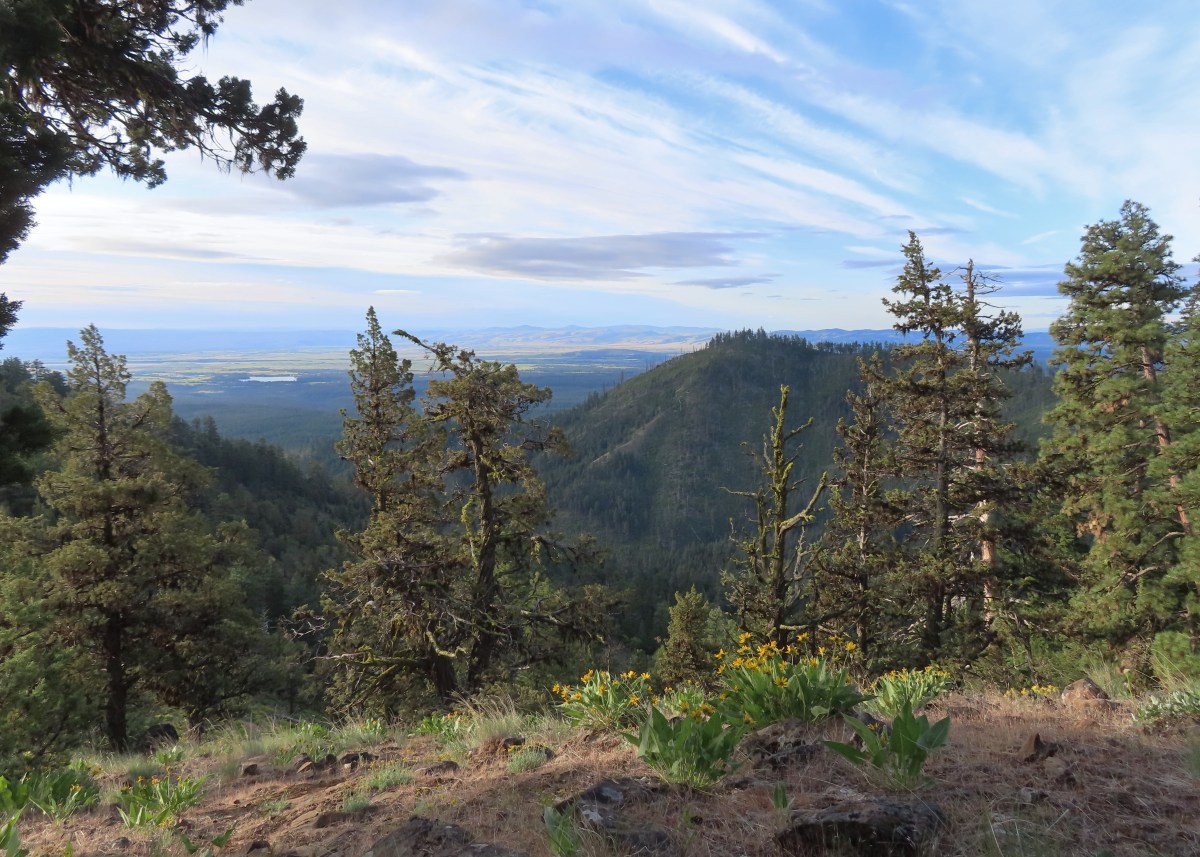
 The Tygh Creek Trail across FR 27 from the Tygh Creek Trailhead.
 The only two trees down that needed to be climbed under/over.
 Tygh Creek
 Distance + low light + moving animal = blurry photo.
 The skunk had been at the far end of this section of trail which was lined with lupine.
 The little stinker had a pretty cute face.
 The trail is to the right in this photo.
 Paintbrush, balsamroot, and a strawberry blossom.
 Ball Point
 Rough eyelashweed
 When a trail looks steep in a photo that tells you something.
 More paintbrush and balsamroot.
 Townsend’s solitaire
 Buckwheat
 My goal, the turn around point, was up on the crest of that ridge ahead.
 Lupine, balsamroot, and a death camas.
 Dogwood tree among the ponderosa pines.
 Mahala mat
 Getting close to the ridge and still steep.
 The trail got less steep near the ridge.
 Gordon Butte to the right. Broken Top, the Three Sisters, and Mt. Jefferson would also have been visible if not for the clouds.
 Level trail on the ridge!
 Looking ahead at the trees atop the “small” ridge.
 Sandwort
 Oregon sunshine
 Wildflowers on the “small” ridge.
 Almost to the crest.
 The clouds here are hiding Mt. Hood which should be visible behind the ridge. What is visible is Flag Point (
 Looking toward Mt. Jefferson.
 Parts of Mt. Jefferson peeking out through the clouds.
 I’d seen a couple whitestem frasera going up but coming down I realized just how many there actually were, although none of the plants were quite blooming yet.
 Groundsel
 Broken Top and some of the Three Sisters were visible on the way down.
 Tam McArthur Rim (
 I missed this whole patch of silvercrown earlier.
 Pine Hollow Reservoir and Central Oregon.
 Elkhorn clarkia aka ragged robin.
 Threadleaf phacelia
 Paintbrush with Ball Point in the background.
 Vetch
Vetch Penstemon
 Bastard toadflax
 Back in the forest near Tygh Creek.
 Tygh Creek
 Squirrel
 Starflower
 Coral fungus
 The trailhead in sight.
 The Tygh Creek track along with a portion of Saturday’s hike on the School Canyon Trail at the bottom.


 Phacelia
 Fleabane
 Thistle
 Madia
Madia
 Fiddleneck and lupine
 The first of several deer we spotted during the day.
 The distinctive cliffs behind the lupine are across the river from the parking area so we were almost always able to tell where we had parked.
 This jeep track would veer to the left to pass between the smaller hills and cliffs ahead.
 Western meadowlarks could be heard throughout the hike.
 The view south.
 Desert yellow fleabane
 The view west.
 Mt. Hood peaking over the canyon rim to the NW.
 Mt. Hood
 Butterfly on yarrow
 Grasses and wildflowers added color to the landscape.
 The route became very faint at times.
 Balsamroot
 Looking back at the route so far.
 View from the trail after passing between the hills and cliffs.
 An old fence.
 Mt. Hood and Lookout Mountain (

 Buckwheat

 Rough eyelashweed
 Paintbrush


 Another stretch of faint tread.
 It was often easier to see the road ahead than below our feet.
 Balsamroot and lupine
 Grand collomia and lupine.
 Spreading dogbane
 Digging in.
 Small water trough (empty).
 View from the water trough.
 Haven’t identified this bird yet.
 Looking back at the route again.
 Mt. Hood again.
 Ochre ringlet. There were hundreds of butterflies.
 Looking at the climb ahead. At this point most of the rest of the hike would be in direct sunlight, and it was already getting warm.
 Buck
Buck Buck number two.
 We had to get pretty high up before we could see Washington’s Mt. Adams and even once it was in view the lighting made it hard to make out.
 Mt. Adams
 The newer barbed wire fence at the public land boundary. This is around 3.5-miles from the parking area.
 Hawksbeard
 The fence went up and down steeply so that meant we got to as well.
 Crow
Crow Fritillary
 Cattle trail
 Western kingbirds
 A milkvetch
 Another butterfly on balsamroot.
 Stag Point is the high triangular point along the plateau in the foreground.
 Zoom in on Stag Point. (The lone post on top gives it away.)
 First and only brief view of the top of Mt. Jefferson.
 Mt. Jefferson
 The newer fence turned left at the corner.
 Onion
Onion This rocky gully was a little tricky to cross.
 Checkerspot
 Old stone structure along the fence.
 Western meadowlark
 Lark sparrow
 Probably cattle bones.
 Checkerspot on fiddleneck.
 Balsamroot and Mt. Hood from the road.
 Phlox
Phlox Indra swallowtail
 Checkerspot
 Another checkerspot
 A blue or copper of some sort.
 Oregon sunshine
 Skipper
 Colorful rocks
 Looking back up along the switchback section.
 Gate along the road at the end of the switchbacks.
 Allumroot

 Cusick’s sunflowers and desert yellow fleabane.
 Cusick’s sunflowers
 Looking back up the road toward the snake.
 The still coiled snake to the right of the track.
 The fainter jeep track split off here to the right. It’s really hard to see it in the photo but was a little more obvious in person.
 The goal was to aim for the knoll ahead then find two junipers that were relatively close together and descend between them.
 Looking back up from the jeep track.
 The view upriver with a private house.
 Going between the two junipers.
 Looking back up at the two junipers.
 It’s a checkerboard of public and private land along the road. While this portion of the road is open to hikers, public fishing along the riverbank is limited to the public land portions. No trespassing signs line the road in the private sections.
 Heather spotted this rattlesnake off the side of the road. We couldn’t tell if it was still alive and didn’t really want to find out.
 One of the few bits of shade along the road walk.
 Probably some sort of flycatcher.
 There were a lot of osprey along the river.
 There were also quite a few Bullock’s orioles.
 Mock orange along the river.
 Mallard
 Bindweed
 Another unknown bird and an angler in the river.
 Cliff swallow
 Dove
Dove More osprey
 Portland Deschutes Club Gatekeepers House

 Geese
Geese Common merganser
 Yarrow covered hillside.
 Rock formations above the road.
 The distinctive cliffs on the opposite side of the river from the parking area.
 Arriving back at the parking area.
 Yellow is our track from 2023.
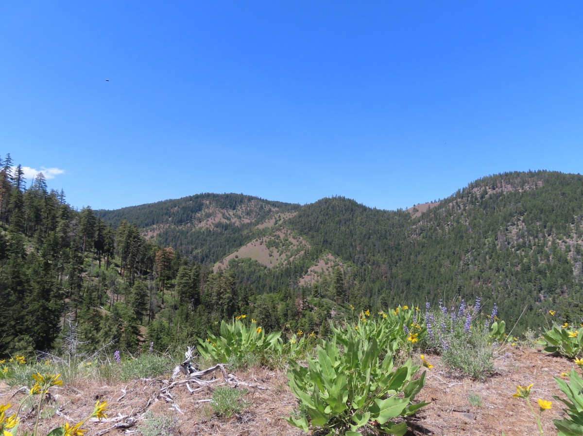


 We headed off through the trees here.
 Mt. Jefferson and Olallie Butte (
 Gordon Butte in the foreground.
 Balsamroot and oak trees.
 Buckwheat and balsamroot
 Whitestem frasera with Mt. Jefferson in the background.
 Rough eyelashweed
 Paintbrush
 We picked up a faint path, not sure if it was a game or use trail.
 Lupine and ponderosa pines.
 The trailhead is on the opposite side of FR 2710 from the trail.
 Sign at the start of the Little Badger Trail.
 Badger Creek Wilderness sign next to Little Badger Creek.
 Groundsel
 Woodland stars
 Little Badger Creek
 Fairy slipper
 American vetch
 Bastard toadflax
 Duskywing on sagebrush false dandelion.
 Balsamroot
 Bee coming in for a landing on phacelia.
 Sticky cinquefoil
 Western wood-pewee
 Madia
Madia Brown elfin (and another pollinator) on Oregon sunshine.
 Starflower
 Mahala mat along the trail.
 Duskywing on blue-eyed Mary
 Largeleaf sandwort along the trail.
 Skunk cabbage
 Red-flowering currant
 Duskywing on arnica
 Silvercrown
 Oregon grape
 Last of the trillium.
 Plumed solomonseal
 What’s left of the cabin.
 Little Badger Creek at the cabin site.
 Anemone
 There was a short climb before reaching the spur trail.
 Spur trail to the mine.
 The old mine. We did not go in as wildlife do sometimes use it for shelter.
 Ballhead waterleaf near the mine.
 Western tanager
 A stand of oaks ahead.
 Balsamroot along the trail.
 Paintbrush
 Buckwheat
 Juniper trees
 Threadleaf phacelia


 Signpost ahead for the trail junction.
 Wildflowers along the trail.
 The spur trail on the left to the Helispot.
 Penstemon

 Pine Hollow Reservoir in Central Oregon.

 Woodland star
 This was the most significant obstacle we had to navigate on the entire loop.
 Yarrow
 A dogwood on top of the rocks and penstemon below.
 First view of Ball Point.
 Penstemon
 From the ridge we could faintly make out Broken Top and the Three Sisters.
 The Three Sisters on the right and Broken Top with Tam McArthur Rim (
 Pen Point across the Tygh Creek Valley.
 Passing through the 2009 Ball Point Fire scar.
 Pen Point toward the center and the taller Hootnanny Point to the right.
 Death camas
 View east as we came around Ball Point.
 Desert yellow fleabane.
 Prairie smoke aka Old Man’s Whiskers


 Heather coming down the ridge.
 I think this is a western racer.
 Looking up at the ridge.
 A clarkia
 Lewis’ woodpecker
 Lizard


 On last view of Mt. Jefferson
 Ball Point
 Butterfly on whitestem frasera
 Signs at the trailhead.
 Orange is the road + cross country portion.
 This trail is part of the
 Damaged footbridge over Morganroth Creek at the 0.2-mile mark.
 The Wetland Loop Trail split off just beyond Morganroth Creek. I stayed right and planned on returning via the loop.
 This was a muddy trail which isn’t surprising for an area that receives 120″ of rain (3 meters) on average annually.
 Youth-on-Age
 Approaching the Bogachiel River.
 Bogachiel River
 The other end of the Wetland Loop was approximately a half mile from the Olympic National Park boundary.
 Kahkwa Creek. The log down in the distance was crossable but I opted to ford the creek on my first pass.
 Ford at Kahkwa Creek.
 Signs at the park boundary. The trail name changes here to the Bogachiel River Trail.
 Wilderness permits for back country camping. At this point I was not only in the park but also the

 The dry creek where I turned around.
 The log crossing over Kahkwa Creek.
 The Wetland Loop Trail junction was near the Kahkwa Creek crossing.
 The Wetland Loop began along Kahkwa Creek.

 Skunk cabbage
 The Wetland Loop traversed up and down along a hillside above some wetlands.
 Scouler’s corydalis
 Wetlands below the loop trail.
 Completing the loop.
 Fairy lanterns


 Notice regarding the petroglyphs on Wedding Rocks. By the time we were on the beach we’d completely forgot to look for these. We did run into another hiker who had seen them on a prior trip, but he couldn’t remember where. He thought they were located at some rocks near where we’d run into him, so we searched those rocks for several minutes with no luck. As it turns out he was mistaken as to where Wedding Rocks was, it is located on the first rocky headland nearest Cape Alava at the northern end of the triangle hike. We were much closer to the southern end.
 Ozette River leaving Ozette Lake.

 Bunchberry
 Slug on a skunk cabbage leaf.
 Skunk cabbage
 Bog laurel along the trail.
 Closer look at the bog laurel blossoms.
 Squirrel
 First view of the ocean.
 Beach bunny
 Ozette Island. The signpost is used to identify inland trails that bypass the beach.
 Bodelteh Islands
 Heading south along the beach.
 We had heard sea lions somewhere in the direction of Ozette Island as we were approaching the beach.
 There is a seal in the foreground and a couple of sea lions on the rocks beyond.
 Seals lounging on the rocks.
 One of several campsites along the beach.

 Approaching Wedding Rocks. There is a bypass sign ahead if you look closely. At higher tides it is not possible to go around the rocks along the beach.
 A couple of crabs taking a defensive position as we were passing by.
 Wedding Rocks
 On the other side of the Wedding Rocks. As I mentioned before this is where the petroglyphs are, but we’d already forgotten to be looking for them. In Heather’s defense she had started to come down with a cold the previous day and was not feeling 100%. I however had no excuse.

 Looking back at the Wedding Rocks.
 Robin
Robin Bald eagle
 Whimbrel
 Hole in a sea stack.
 Seals and cormorants
 The second rocky headland where there was an inland bypass route. On the far side is where we ran into the hiker who thought these were the Wedding Rocks where he’d seen the petroglyphs before.
 Path through the rocks. It made sense to us that this would be where the petroglyphs were given there were several passages between the rocks here.
 Coming out the other side.
 Looking back at the rocks that weren’t the Wedding Rocks.
 Sandpoint ahead.
 Semipalmated plover
 View south
 One of the groups of backpackers heading north from Sand Point.
 Chickweed on the headland.


 Evergreen huckleberry blossoms.
 Bench along the trail.
 Groundcone. Heather had a sharp eye to pick this up on the forest floor.
 There were a couple of missing sections of boardwalk along this side of the triangle.
 Ozette Lake


 James and Little James Islands
 The beach was mostly small pebbles to start. Our steps often sunk more than expecting requiring more effort than we’d have guessed. We spent quite a bit of time trying to find the most solid ground.
 Our footsteps on the beach.
 Stump in the sand.
 Ellen Creek. The creek flowed under the beach and emerged shortly before the ocean.
 Seagull
 Bald eagle


 Looking back through the arch.


 This racoon was searching the tide pools for breakfast.
 Looking back toward Hole-in-the-Wall.

 Many of the dark spots on these rocks are the small crabs.
 Does anyone know what this is?

 Oyster catcher
 Cormorants
 Cape Johnson in the distance.
 Paintbrush
 Unnamed creek not quite making it to the ocean above ground.
 Cape Johnson

 I turned around at the slide ahead.
 Hermit crab shells
 A good example of the challenging terrain.
 Seagull, oyster catchers, and a cormorant.
 Paintbrush on the cliffs above the beach.
 Hole-in-the-Wall and James Island back in view.
 Not a great picture due to the extreme zoom and low lighting. After looking closer at this photo I began thinking it was just a rock in the surf. Then I looked at the next photo and what would be the foot and the head were in different positions.
 Possible sea otter.
 The area around Hole-in-the-Wall was a lot busier on the way back.
 Driftwood on the beach.
 Heather spotted this little starfish while exploring the tide pools near the arch.
 Heather also spotted this which we believe is a velella velella.
 Starfish and anemones
 Bald eagels
 On the jetty looking at James Island.
 La Push across the river.
 Sea lion in the river.
 Heading back to the trailhead along the jetty.
 The jetty is actually part of the Quileute Indian Reservation.

 Map of the area trails at the trailhead.
 Anyone know why the spelling on the sign is different?
 Violets
 Bridge over an unnamed creek.
 Trillium
 Coltsfoot
 Fairy bells


 Depending on the volume of water there are up to four channels which was the situation on this day.
 Heather on the bridge above the falls.


 Storm King Ranger Station
 Forget-me-nots (non-native) along the trail.
 Lake Crescent

 Storm King Trail to the left.
 Marymere Falls Trail junction with the Barnes Creek Trail.
 Footbridge over Barnes Creek.
 Barnes Creek
 Trillium
 Footbridge over Falls Creek almost immediately after crossing Barnes Creek.
 Falls Creek
 Start of the clockwise loop.

 Marymere Falls
 The trail climbing up from the first viewpoint.
 Marymere Falls from the second viewpoint.
 Final viewpoint before the loop curved away from the falls and descended back to its start.
 The footbridges over the two creeks.
 Unnamed fall on Falls Creek from the footbridge.
 It was now almost 9am so there were a few cars parked here already.

 Various poems were located along the first mile of the trail.
 This trail is open to a variety of users.
 Haiku
Haiku

 A second haiku.
 Common whipplea
 Starflower
 Valerian
 Clear water in Lake Crescent.
 Paintbrush
 Something in the pea family.
 Nearing Devil’s Punchbowl.
 Devil’s Punchbowl
 There was a fair amount of poison oak along the trail to Devil’s Punchbowl.
 Madrones
 Honeysuckle
 Common cryptantha
 Rejoining the railroad trail on the far side of the tunnel.
 Butterfly
 Another type of trail user.
 View west.
 View east.
 Big deervetch
 Fairy slippers
 Chipmunk
 Woodpecker
 Lake Crescent Lodge on the far side of the lake.
 Squirrel
 Wallflower
 The second tunnel.
 Thimbleberry
 White crowned sparrow
 Going through the tunnel.
 I went a little further around this bend while Heather took a seat on a log after exiting the tunnel.
 Paintbrush
 View across the lake toward the Barnes Creek Valley.
 I believe the snowiest peak is Lizard Head Peak.
 Saxifrage
 Chickweed
 Swallow
 Oregon sunshine
 Lupine
 Stonecrop
 Variable-leaf collomia

 This was a longer tunnel and had little light near the middle.
 Descending to the trailhead.

 The lake from the picnic table.
 Common loon
 These mallards came flying in then waddled up to see if they could scrounge something from us, but we explained that we do not feed the wildlife (
 Stellar’s jay
 Trying to find the route to the lodge.
 Mushroom
 The lodge is just on the other side.


 Interpretive signs explaining the creation of Lake Crescent by glaciers.
 This trail had good signage unlike the area near Bovee’s Meadow.

 Chair near the lodge.
 Lake Crescent Lodge.
