We woke up to the news of military action in Iran, a somber reminder of the state of the world today. Our prayers are with all the families across the globe impacted. We’re thankful to still have the opportunity to step away and enjoy the outdoors.
We had picked a pair of hikes near Lebanon, OR McDowell Creek Falls and Cheadle Lake. We had visited the former in February 2014 (post) while the latter would be new for us as a hike. (We had run part of this route in the early 2010’s as part of the Runaway Pumpkin half marathon races.)
We started our morning at McDowell Creek County Park for the relatively short loop that visits four named waterfalls. We parked in the lower (western most) parking lot which is referred to as the Royal Terrace Falls Trailhead in the Oregon Hikers Field Guide.


There are restrooms and picnic tables available at the trailhead.
After double checking the map, we set off on the trail across McDowell Creek.


After 0.2-miles we came to the start of the loop and opted to go left for a view of Royal Terrace Falls from the footbridge across Fall Creek.


The start of the loop.


Royal Terrace Falls

Bench of the far side of the bridge.
Beyond Royal Terrace Falls the trail recrossed McDowell Creek then crossed McDowell Creek Road before arriving at Crystal Falls aka Crystal Pool a third of a mile from Royal Terrace Falls.


McDowell Creek


McDowell Creek Road from the crossing.

Crystal Falls ahead through the trees.
A use trail led down to the creek for a better view of the falls.

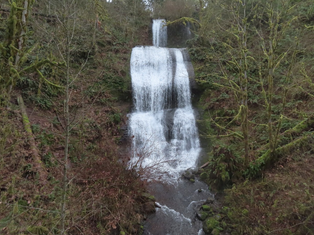
Just over a tenth of a mile past Crystal Falls the trail arrives at an impressive wooden walkway near Majestic Falls.


Majestic Falls
Stairs led up from Majestic Falls to a viewpoint platform at the top of the waterfall.


From the upper viewpoint we faced a choice of going directly uphill to the upper parking lot or taking a slightly longer route by swinging out along the creek for a short distance. We had gone directly up in 2014 so this time we chose to swing out along the creek.


Stairs up to the upper lot.

Robin near the upper lot.
We crossed the road near the upper parking lot and in 0.3-miles
recrossed McDowell Creek Road.


Pointer for Royal Terrace Falls at the crossing of McDowell Creek Road.
In another 0.3-miles we arrived at Fall Creek above Royal Terrace Falls.


Viewing platform above Royal Terrace Falls

Looking down at the bridge below Royal Terrace Falls.
We took a short detour up a use trail along Fall Creek which didn’t lead anywhere of note then headed down the stairs along Fall Creek to complete the loop.

Fall Creek along the use trail.


Royal Terrace Falls from the stairs.
When we were back at the lower parking lot we followed a short trail downstream to a view of Lower McDowell Falls.

The hike here was just 2.2-miles with a little over 200′ of elevation gain leaving us plenty of energy for a second stop.

It was less than a 20-minute drive from McDowell Creek to Cheadle Lake in Lebanon. We had initially planned on parking at Cheadle Lark Park however there was quite a bit of construction equipment present, and it was unclear if the trails at this end of the area were open, so we shifted to “Plan B” and made our way to nearby Riverview Park.

We stopped at the signboard for the Old Mill Trail and studied the map for a moment and downloaded a digital copy then headed right (south) on a paved path. (It was unclear if this was the Old Mill Trail or the West River Trail, nevertheless it would take us to Cheadle Lake.)


The South Santiam River from the trail.
This trail led us into a neighborhood and to Mountain River Drive.


Here the pointers refer to the West River Trail.
We followed the sidewalk for 100 yards to a crosswalk at River Drive then continued another tenth of a mile to Cheadle Lake Park’s boat ramp parking area.


From this parking lot the paved North Shore Trail passes along the northeastern shore of Cheadle Lake between the lake and the Lebanon Santiam Canal. We were on the lookout for waterfowl and other birds as we started off.


Mallards


Geese

Ring-necked duck

American wigeon


Ridgeway Butte beyond a farm across the canal.

American wigeons and domestic ducks on the farm.
After four tenths of a mile we arrived at the Island Loop Trails which are a series of fingers in the middle of the lake.


We hiked out-and-back on the eastern most finger before returning to the North Shore Trail.


Pied-billed grebe

Bench at the end of the finger.

Gadwall
Back on the North Shore Trail we continued SE and spotted a pair of hooded mergansers in the canal.


Spotted towhee


Song sparrow
At the far end of the lake, we arrived at a 4-way junction within sight of the parking lot we had originally planned on starting from.

The park map showed a dashed (proposed) Southshore Trail heading right from this junction. The proposed trail would loop around the lake to the boat ramp. We had not paid attention to the “proposed” verbiage when we decided to turn right and try the loop. Initially the trail was paved with benches but the pavement soon ended and was replaced by a dirt trail through the grass.


California scrub jay.

Oregon grape

The finger that we had hiked out earlier.
The trail lasted a little over half a mile before petering out on the north side of a soccer field at a marsh. It was at this point that we noticed the “proposed” label on the map. Since looping around the lake wasn’t an option, we looped around the soccer field and headed back the way we’d come.

The soccer field is to the left with Ridgeway Butte ahead.

Heading back on the North Shore Trail.
We had discussed being surprised at having not seen a bald eagle on our first pass along the lake. That changed as we passed the Island Loops.

Bald eagle spotted.


Cormorants
From the boat ramp we headed back toward Riverview Park and took the gravel fork at the southern end of the park.


Heather had a blister starting so she headed back to the car while I continued around the park to the Eagle Scout Trail.


I turned on the Eagle Scout Trail and followed this dirt path 0.8-miles to the paved Old Mill Trail near Gill’s Landing


Indian plum

Bewick’s wren

Old Mill Trail near Gill’s Landing.
I returned to Riverview Park on the Old Mill Trail completing a 6.4-mile hike with minimal elevation gain.


Old mill site.

Riverview Park

This was a nice pair of hikes. We knew that McDowell Creek Falls was a great hike, but Cheadle Lake was surprisingly quite for an in-town hike and the birding turned out to be pretty good. Happy Trails!


 Arnica


 Arnica


 Spirea, tiger lilies, columbine, valerian, and cinquefoil.


 Small parking area at Wildwood Falls Park.


 We’ve found that the Forest Service seems to sometimes round milage shown on trail signs.


 We took a break in this rocky section of trail which was the only place we could find where the mosquitoes weren’t too plentiful. The lower portion of the trail had been fine but as we climbed the mosquitoes became more plentiful. While we were taking our break we heard the distinctive “meep” of a pika “meep”, but we weren’t able to spot any.


 Rough tread on the Marten Flume Trail.


 Dotted line is the current loop. Green is our track from 2016 and red is a part of our Brice Creek Hike in 2014.
 The small blue sign on the left provides the pay by phone information. This was one of two such signs in the parking area.

 Little Joe Creek
 The pointer to the right was for the Sandy and Salmon Rivers (.25 miles) while continuing another .18 miles would bring us to the Sandy Ridge Trail System.


 Start of the Falls Looop.
 Primitive Trail number 2 with the Falls Loop continuing to the left.

 This was a nice little cascade this time of year. Later in the Summer the flow reportedly drops down to a trickle.
 The self-guided nature tour follows the Northern Loop Trail here as well.
 Passing stop #6 on the self-guided tour (Forested Headwaters).
 One of the creeks flowing from the forested headwaters.


 There are a few Eagle Creeks in Oregon, this is the Eagle Creek that originates in the Salmon-Huckleberry Wilderness (


 Snow queen
 One of several switchbacks.
 Rough-skinned newt and snow queen.
 Closer look at the newt.
 Blue sky
 Traversing the hillside.
 The trail below as we neared a switchback to begin descending.


 Viewpoint near the end of the loop.
 The start of Loop D from Kitzmiller Road.
 The remains of former signs can be seen at the split ahead.
 The trail made a steady climb to the junction with the supposed Lollipop Loop.
 The lower portion of the tree across the switchback.
 Left is the continuation of Loop D. We stayed right to attempt the Lollipop Loop.
 There were some cut trees along the trail mixed with more recent blowdown but nothing was particularly difficult to navigate.
 Wren
Wren There was a lot of snow queen.
 The footbridge with a large tree across it.
 Look back along the bridge.
 The older blowdown had all be cut.
 I made it through this muddy mess but couldn’t find any sign of tread on the opposite side.


 Swagger Creek
 Song sparrow (according to Merlin)

 The second unsigned junction.


 Swagger Creek (right) joining Clear Creek at the suspension bridge.
 The Nature Trail wasn’t signed other than some “No Motor Vehicles” signs.
 The old roadbed.
 Relative locations of the three stops plus Milo McIver from our previous outing.


 McIver Memorial Viewpoint
 Clackamas River from the viewpoint.
 The small trail sign on the left is labeled “Viewpoint Trail”.
 Map on the signboard. Oddly the Viewpoint Trail is not shown on this map even though the trail continues past the signboard.
 The Vortex Meadow through the trees.


 Former model airplane landing strip in the meadow.

 There were some limited views of the Clackamas River from this trail.
 While we were happy to see trail signs again it was a little confusing to see the Riverbend Trail pointer here. Here again the maps that we had did not show this junction. They did show a 4-way junction between the Riverbend Trail and Vortex Loop but only after crossing a road which we had not done.


 Viewpoint near the group camp.

 Had we not backtracked through the group camp we would have connected with the Riverbend Trail after crossing a road then turned right on the Riverbend Trail, recrossed the road, and arrived at this junction on that trail which was now on our left.


 Stellar’s jay

 We stumbled on a one-leg standing competition that the local geese were engaged in.
 The mallards seemed unimpressed with the geese’s balancing abilities.
 Common mergansers


 Common merganser drake
 We found this nice little bridge wandering around the disc golf course attempting to connect with the Maple Ridge Trail.


 The Cedar Knoll Trail connects the upper and lower segments of the Maple Ridge Trail. We stayed right on the Maple Ridge Trail.
 Colorful fungi
 Wood ducks on Wood Duck Pond. It’s pretty rare that the animal a feature is named after is actually present.


 Not sure if this is just the biggest rough-skinned newt we’ve ever seen or a different type of salamander.
 Great blue heron by a small pond. It was probably hunting the frogs that were croaking loudly here.
 The sign ahead is for the Cedar Knoll Trail joining from the left.
 Dropping down to the Riverbend Loop Trail junction.
 The Maple Ridge Trail makes another nearly 180 degree turn here and drops down to the parking area a short distance from its other end.
 We stayed right here again at a junction with a trail leading to the Maple Ridge Picnic Shelter.
 I believe these are sweet coltsfoot starts.
 There was a bench next to this nice little creek.
 Nearing the Riverbend Day Use Area entrance road.


 Song sparrow

 It’s hard to make out but there is a coyote in this photo.
 I have no idea what’s going on with this photo of the coyote as it was trotting away from us. Shortly after this it popped out from behind some brush and jumped into the air to pounce on something. That was the last we saw of it.
 Squirrel
 Left to right: Silver Star Mountain, Little Baldy, and Bluff Mountain (
 Mt. Hood making a partial appearance.

 The trailhead.
 The caution sign was related to some pile burning that the Forest Service had been doing.
 McKenzie River

 Mushrooms
 National Recreation Trail symbol on a tree to the left.


 Private Road sign on Duffy Rd.
 There was quite a bit of witches’ butter fungus along the trail.
 There were a lot of other mushrooms too.
 Unnamed creek crossing.


 Ruby-crowned kinglet. We didn’t see much wildlife on this hike but there were several kinglets flitting among the trees here. This was the only photo of one I managed to get though.
 We had not expected any blue sky so this was a treat. It had rained for most of the drive and sprinkled for a minute shortly after we started hiking, but it had been dry otherwise.
 The trail switching back up a small hill.
 The most significant elevation change was this decent to a footbridge over Lost Creek.
 Coral fungus
 Lost Creek
 The footbridge over Lost Creek was a little over 4.5-miles from the Lower McKenzie Trailhead.
 Lost Creek
 Willamette National Forest Boundary
 Approximately 5.25-miles from the trailhead we crossed Belknap Hot Springs Road.
 Sign for the
 Unnamed seasonal stream.
 Footbridge over Scott Creek.
 Scott Creek
 Mushrooms
 Footbridge over Boulder Creek.
 Highway 126 bridge over Boulder Creek from the footbridge.
 Boulder Creek flowing into the McKenzie River.
 Forest Road 2650.
 Boat ramp at Forest Road 2650.
 The river from Forest Road 2650.

 This short section along the road is just east of Belknap Springs Road.
 Madrones
 A little sunlight on the forest floor.
 Rain shower falling over Lost Creek. It wasn’t raining hard enough to convince me to pull my rain gear back out.
 I spotted Heather with a little over three and a quarter mile left back to the trailhead. (Look for a little orange in the trees ahead and to the right of the trail.)


 Ours was the only car at the trailhead when we got back.
 Red – Clear Lake, June 2014 (
 This trail would eventually end at the LoneWolf/Patterson Mountain Trail (
 The small trailhead along Highway 58.
 Wrong way dummy.
 The South Willamette Trail to the right.

 It was clear that mountain bikers use this trail regularly.


 I actually waited until I was on my way down to step off trail and look at the arch.
 Eula Ridge Trail sign at the Hardesty Trail junction.
 The lefthand fork leads to the viewless summit while the right is the Hardesty Cutoff Trail which bypasses the summit.
 Forest below the Hardesty Cutoff Trail.
 The Sawtooth Trail dropping to the right.
 I was not looking forward to climbing back up some of these sections later.
 Another saddle.
 A view through the trees.
 I passed the Hardesty Way Trail 1.5-miles from the Hardesty Cutoff Trail.
 Mount June from the hillside.
 Wallflower
 Junction with the Lost Creek Trail.
 The pointer for Eagles Rest (
 I called this section “rhododendron ridge”.
 The Mt. June Trail coming up from the right.


 If you look closely, you can see the tops of the Three Sisters poking up over the smoke in the distance. The open hillside in the foreground is the meadow below Sawtooth Rock and the hump just behind is Hardesty Mountain.
 Heading down from the summit.
 Climbing the hillside below Sawtooth Rock.
 Sawtooth Rock
 There was just a little smoke now and then in the forest.
 The Eula Ridge Trail coming into view.
 There wasn’t much in the way of Fall colors along the trail, but these leaves really stood out.
 Lookout Point Lake (Middle Fork Willamette River) from the trail.
 There was one more small uphill on the far side of South Creek before dropping to the trailhead.
 South Creek

