After spending a second night in The Dalles it was time to return home, but before we headed to Salem we had one more hike to do in the area. There was one more hike on the east side of the Badger Creek Wilderness featured in Matt Reeder’s “Off the Beaten Trail” (2nd edition) guidebook – Tygh Creek. His recommended hike on the trail is a 4-mile out-and-back gaining 1700′. If that sounds steep, it is!
We left The Dalles and drove south on Highway 197 and made our way to the unsigned Tygh Creek Trailhead along Forest Road 27.
 The Tygh Creek Trail across FR 27 from the Tygh Creek Trailhead.
The trailhead is just 1.4-miles from the School Canyon Trailhead where we had started our hike two days earlier (post). It is theoretically possible to combine the two trails into a 13.7-mile loop, but the upper portion of the Tygh Creek Trail is reported faint and prone to heavy blow down. Even if the trails were clear we didn’t have time for a long hike today, so the 4-mile option was perfect.
For the first half mile the trail did a little up and down along Tygh Creek.

 The only two trees down that needed to be climbed under/over.
 Tygh Creek
At the half mile mark the trail left the creek and began the steep climb to the ridge above.

Heather had opted to not tackle the climb after already having done two challenging hikes this weekend so I had left the car before her and was on my own heading uphill when I spotted something moving in the forest ahead. I noticed the black first but then saw white as well and realized it was a skunk on the trail ahead.
 Distance + low light + moving animal = blurry photo.
 The skunk had been at the far end of this section of trail which was lined with lupine.
I stopped and watched the skunk head uphill until it was out of sight and then proceeded carefully not wanting to wind up smelling of skunk for the entire ride home. (I’m sure Heather would not have appreciated that either.) It was a good thing I was being cautious because after a short distance I noticed the skunk in some brush just off the trail.

 The little stinker had a pretty cute face.
We stared at each other for a minute, and I politely requested it move along. When that didn’t work I left the trail in an attempt to swing out wide and pick up the trail further uphill. My moving again prompted the skunk to run off deeper into the forest with its tail in “firing position”. I hoped it wasn’t randomly spraying the air which might still get me but fortunately the safety was kept on and I was in the clear to continue the hike.
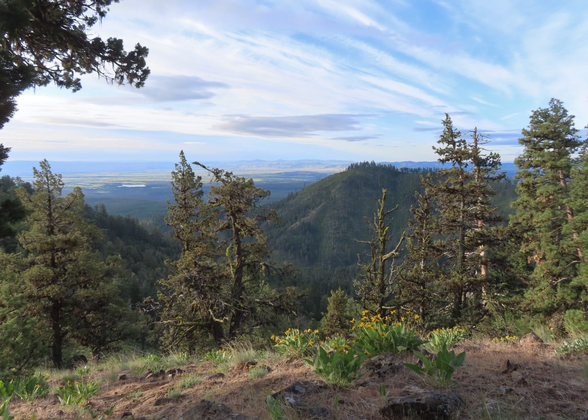
Reeder mentioned the middle third of the 0.9-mile climb as being “some of the steepest, dustiest trail in the Badger Creek Wilderness.” From the sample of trails we’ve hiked in this wilderness I’d agree with that statement. The first and final third were no picnic either. There were however great views and a lot of wildflowers to look at as I slowly trudged uphill.
 The trail is to the right in this photo.
 Paintbrush, balsamroot, and a strawberry blossom.
 Ball Point
 Rough eyelashweed
 When a trail looks steep in a photo that tells you something.
 More paintbrush and balsamroot.
 Townsend’s solitaire
 Buckwheat
 My goal, the turn around point, was up on the crest of that ridge ahead.
 Lupine, balsamroot, and a death camas.
 Dogwood tree among the ponderosa pines.
 Mahala mat
 Getting close to the ridge and still steep.
 The trail got less steep near the ridge.
 Gordon Butte to the right. Broken Top, the Three Sisters, and Mt. Jefferson would also have been visible if not for the clouds.
 Level trail on the ridge!
The hike describes cresting a “small” ridge and finding a user trail on the left that leads to a viewpoint sometimes used as a helispot. I headed out the ridge and quickly realized that my definition of “small” and Reeder’s were not the same.
 Looking ahead at the trees atop the “small” ridge.
 Sandwort
 Oregon sunshine
 Wildflowers on the “small” ridge.
 Almost to the crest.
While I never actually spotted a use trail it was easy to see the opening where a helicopter could land just to the left of the trail, so I made my way out to the opening.

 The clouds here are hiding Mt. Hood which should be visible behind the ridge. What is visible is Flag Point (post) in the middle with the Flag Point Lookout Tower.
 Looking toward Mt. Jefferson.
 Parts of Mt. Jefferson peeking out through the clouds.
After catching my breath at the viewpoint I began the steep descent back to Tygh Creek. I had been so focused on the climb up that I saw a few flowers that I’d missed on my first pass.
 I’d seen a couple whitestem frasera going up but coming down I realized just how many there actually were, although none of the plants were quite blooming yet.
 Groundsel
 Broken Top and some of the Three Sisters were visible on the way down.
 Tam McArthur Rim (post), Broken Top with Green Ridge (post) and Black Butte (post) in front, and parts of the Three Sisters.
 I missed this whole patch of silvercrown earlier.
 Pine Hollow Reservoir and Central Oregon.
 Elkhorn clarkia aka ragged robin.
 Threadleaf phacelia
 Paintbrush with Ball Point in the background.
 Vetch
Vetch
 Penstemon
 Bastard toadflax

Buttes in Cental Oregon.
 Back in the forest near Tygh Creek.
 Tygh Creek
 Squirrel
 Starflower
 Coral fungus
 The trailhead in sight.
The hike was just under 4-miles with 1700′ of elevation gain.
 The Tygh Creek track along with a portion of Saturday’s hike on the School Canyon Trail at the bottom.
Tackling this hike when my legs were already tired from the previous two days wasn’t ideal, but its length was which allowed us to get home to Salem before 11am. It was a little disappointing not having clearer views from the helispot given the effort to get there, but the wildflowers and views that I did have made for a good hike regardless.
In a crazy twist I posted a few photos on Instagram and Matt Reeder himself commented having also hiked the trail a little later that same morning. Happy Trails!
Flickr: Tygh Creek


 Phacelia
 Fleabane
 Thistle
 Madia
Madia
 Fiddleneck and lupine
 The first of several deer we spotted during the day.
 The distinctive cliffs behind the lupine are across the river from the parking area so we were almost always able to tell where we had parked.
 This jeep track would veer to the left to pass between the smaller hills and cliffs ahead.
 Western meadowlarks could be heard throughout the hike.
 The view south.
 Desert yellow fleabane
 The view west.
 Mt. Hood peaking over the canyon rim to the NW.
 Mt. Hood
 Butterfly on yarrow
 Grasses and wildflowers added color to the landscape.
 The route became very faint at times.
 Balsamroot
 Looking back at the route so far.
 View from the trail after passing between the hills and cliffs.
 An old fence.
 Mt. Hood and Lookout Mountain (

 Buckwheat

 Rough eyelashweed
 Paintbrush


 Another stretch of faint tread.
 It was often easier to see the road ahead than below our feet.
 Balsamroot and lupine
 Grand collomia and lupine.
 Spreading dogbane
 Digging in.
 Small water trough (empty).
 View from the water trough.
 Haven’t identified this bird yet.
 Looking back at the route again.
 Mt. Hood again.
 Ochre ringlet. There were hundreds of butterflies.
 Looking at the climb ahead. At this point most of the rest of the hike would be in direct sunlight, and it was already getting warm.
 Buck
Buck Buck number two.
 We had to get pretty high up before we could see Washington’s Mt. Adams and even once it was in view the lighting made it hard to make out.
 Mt. Adams
 The newer barbed wire fence at the public land boundary. This is around 3.5-miles from the parking area.
 Hawksbeard
 The fence went up and down steeply so that meant we got to as well.
 Crow
Crow Fritillary
 Cattle trail
 Western kingbirds
 A milkvetch
 Another butterfly on balsamroot.
 Stag Point is the high triangular point along the plateau in the foreground.
 Zoom in on Stag Point. (The lone post on top gives it away.)
 First and only brief view of the top of Mt. Jefferson.
 Mt. Jefferson
 The newer fence turned left at the corner.
 Onion
Onion This rocky gully was a little tricky to cross.
 Checkerspot
 Old stone structure along the fence.
 Western meadowlark
 Lark sparrow
 Probably cattle bones.
 Checkerspot on fiddleneck.
 Balsamroot and Mt. Hood from the road.
 Phlox
Phlox Indra swallowtail
 Checkerspot
 Another checkerspot
 A blue or copper of some sort.
 Oregon sunshine
 Skipper
 Colorful rocks
 Looking back up along the switchback section.
 Gate along the road at the end of the switchbacks.
 Allumroot

 Cusick’s sunflowers and desert yellow fleabane.
 Cusick’s sunflowers
 Looking back up the road toward the snake.
 The still coiled snake to the right of the track.
 The fainter jeep track split off here to the right. It’s really hard to see it in the photo but was a little more obvious in person.
 The goal was to aim for the knoll ahead then find two junipers that were relatively close together and descend between them.
 Looking back up from the jeep track.
 The view upriver with a private house.
 Going between the two junipers.
 Looking back up at the two junipers.
 It’s a checkerboard of public and private land along the road. While this portion of the road is open to hikers, public fishing along the riverbank is limited to the public land portions. No trespassing signs line the road in the private sections.
 Heather spotted this rattlesnake off the side of the road. We couldn’t tell if it was still alive and didn’t really want to find out.
 One of the few bits of shade along the road walk.
 Probably some sort of flycatcher.
 There were a lot of osprey along the river.
 There were also quite a few Bullock’s orioles.
 Mock orange along the river.
 Mallard
 Bindweed
 Another unknown bird and an angler in the river.
 Cliff swallow
 Dove
Dove More osprey
 Portland Deschutes Club Gatekeepers House

 Geese
Geese Common merganser
 Yarrow covered hillside.
 Rock formations above the road.
 The distinctive cliffs on the opposite side of the river from the parking area.
 Arriving back at the parking area.
 Yellow is our track from 2023.
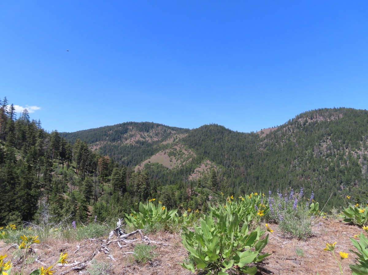


 We headed off through the trees here.
 Mt. Jefferson and Olallie Butte (
 Gordon Butte in the foreground.
 Balsamroot and oak trees.
 Buckwheat and balsamroot
 Whitestem frasera with Mt. Jefferson in the background.
 Rough eyelashweed
 Paintbrush
 We picked up a faint path, not sure if it was a game or use trail.
 Lupine and ponderosa pines.
 The trailhead is on the opposite side of FR 2710 from the trail.
 Sign at the start of the Little Badger Trail.
 Badger Creek Wilderness sign next to Little Badger Creek.
 Groundsel
 Woodland stars
 Little Badger Creek
 Fairy slipper
 American vetch
 Bastard toadflax
 Duskywing on sagebrush false dandelion.
 Balsamroot
 Bee coming in for a landing on phacelia.
 Sticky cinquefoil
 Western wood-pewee
 Madia
Madia Brown elfin (and another pollinator) on Oregon sunshine.
 Starflower
 Mahala mat along the trail.
 Duskywing on blue-eyed Mary
 Largeleaf sandwort along the trail.
 Skunk cabbage
 Red-flowering currant
 Duskywing on arnica
 Silvercrown
 Oregon grape
 Last of the trillium.
 Plumed solomonseal
 What’s left of the cabin.
 Little Badger Creek at the cabin site.
 Anemone
 There was a short climb before reaching the spur trail.
 Spur trail to the mine.
 The old mine. We did not go in as wildlife do sometimes use it for shelter.
 Ballhead waterleaf near the mine.
 Western tanager
 A stand of oaks ahead.
 Balsamroot along the trail.
 Paintbrush
 Buckwheat
 Juniper trees
 Threadleaf phacelia


 Signpost ahead for the trail junction.
 Wildflowers along the trail.
 The spur trail on the left to the Helispot.
 Penstemon

 Pine Hollow Reservoir in Central Oregon.

 Woodland star
 This was the most significant obstacle we had to navigate on the entire loop.
 Yarrow
 A dogwood on top of the rocks and penstemon below.
 First view of Ball Point.
 Penstemon
 From the ridge we could faintly make out Broken Top and the Three Sisters.
 The Three Sisters on the right and Broken Top with Tam McArthur Rim (
 Pen Point across the Tygh Creek Valley.
 Passing through the 2009 Ball Point Fire scar.
 Pen Point toward the center and the taller Hootnanny Point to the right.
 Death camas
 View east as we came around Ball Point.
 Desert yellow fleabane.
 Prairie smoke aka Old Man’s Whiskers


 Heather coming down the ridge.
 I think this is a western racer.
 Looking up at the ridge.
 A clarkia
 Lewis’ woodpecker
 Lizard


 On last view of Mt. Jefferson
 Ball Point
 Butterfly on whitestem frasera
 Signs at the trailhead.
 Orange is the road + cross country portion.


 The trails were well marked with plenty of reminders which users were allowed on them.
 Giant white wakerobin (Trillium albidum)
 The only columbine we spotted.
 Fairy lanterns
 In addition to identifying the trails by name, several had mile markers.
 Trillium

 Solomon’s seal
 Toothwort
 Largeleaf sandwort
 Bleeding heart

 Old fungus
 Oregon grape
 The 2.5-mile marker on the Mossy Maple Trail.
 Seasonal closure sign and map at the upper junction with the bike only Yee-Haw Trail.
 Pacific hound’s tongue
 Fairy slippers
 Star flowered solomon’s seal
 Iris
Iris Vetch
Vetch
 Fringecup
 Strawberry
 Shooting star
 Spotted towhee

 Small-flowered woodland-stars
 Checker lily and baby blue eyes (Nemophila menziesii)
 Manroot
 Red-flowering currant
 Dogwood
 On the Cervus Road passing an old quarry on the right.
 The Basalt Rim Trail.
 The lupine is still a week or so away from blooming.
 Basalt columns


 Fawn lily
 Springfield from the trail.
 There is a short one-way loop at the top.
 Looking down from one of the viewpoints.
 The highest peak to the left in the distance is Mount June (
 Mt. Pisgah (
 Biscuitroot
 Another viewpoint along the loop.
 The peak with two humps is Mount Nebo. With the naked eye we could just make out Tidbits Mountain (
 Camas (and poison oak) near the viewpoint.
 Finishing the loop.
 Stripped coralroot.
 Switchbacks leading down to the Basalt Rim Trail.
 Wren
Wren Violets
 Basalt outcrops
 Ginger
 Arriving back at the Mossy Maple Trail.
 Starflower
 Dunn’s salamander
 Mossy Maple Connector Trail (left).
 The Yee-Haw Trail coming down from the left to the Mossy Maple Connector Trail.
 Buttercups
 Fairy bells
 Meadow near the trailhead.


 Menzies’ larkspur
 Western meadowrue
 Bleeding heart and purple deadnettle
 Completing the loop.
 Faint grassy path.
 Golden crowned sparrow
 A section of obvious trail.
 The faint path disappeared near the fenced off-leash dog area. The AllTrails loop appeared to turn around here, but since we couldn’t see even a faint path leading back around closer to the parking areas we turned around and followed the river back.
 We did find this short section of what appears to have been a paved path in the grass.


 An example of the posts. Every directional arrow, including the far side that you can’t see, was for the “Elk Trail”.
 Cedar along the Elk Trail.
 Candy flower and woodland buttercups
 Picnic tables near Lost Creek.
 Lost Creek
 Not a signed junction so this is the one time we veered right.
 Middle Fork Willamette River.
 I was hoping that there might be a turtle hiding in this photo but alas it does not appear that is the case.
 We veered left here leaving the River Trail briefly to actually get a view of the river.
 We hadn’t noticed the goslings in the grass until seeing the picture of the parents.
 Another look at the river shortly before the River Trail turned away.
 Barrow’s goldeneye
 Left here as right led to a picnic area at the end of the entrance road.
 Signpost at the second junction where we kept right.
 The clouds had been stubborn all morning but by early afternoon they had mostly burned off.
 We stayed left on the trail near the entrance road (across from the

 ADA accessible path to a brushy wildlife viewing spot along a backwater channel.
 Bufflehead and at least three turtles on the logs behind.
 The Lost Creek Trailhead on the far side of the entrance road.


 Atwood Road
 Death camas
 Saxifrage and a yellow bells.
 Grass widows
 Gold stars, wood-land stars, and blue-eyed Mary.
 Catherine Creek from Atwood Road.
 Pungent desert parsley

 Closer look at the arch.
 Buttercup
 I believe this was just our second time coming across these flowers.
 Closer look at the Dutchman’s breeches.
 Hairy bittercress (non-native)
 Entering the sunlight.
 Glacier lilies
 wood-land stars
 Toothwort
 Columbia desert parsley

 Heading through the forest.
 Looking east as the road emerged from the forest.
 Grassy hillside
 Mt. Hood behind a few clouds.
 Mt. Hood
 Popcorn flower
 Rowland Creek
 Another user trail on the left, referred to as the Shoestring Trail by the Oregonhikers Field Guide. This trail is not shown on the Forest Service map nor is it mentioned on their website.
 Coastal manroot
 Grass widows
 View of Mt. Hood’s summit.
 Robin hunting worms.
 Daffodils
 The Upper Labyrinth Trail (aka Co8) joining from below. This was the first junction with signs naming official trails.
 Labyrinth Creek below Atwood Road.
 The Labyrinth Creek crossing.
 Wet trail climbing away from Labyrinth Creek.
 Red-tailed hawk


 Yellow bells

 We stayed left here.
 We ignored the singletrack leading right on the far side of this unnamed stream.
 Here we veered right on the single track. I believe the single track is the “official trail” although both paths led to the signed junction.
 A multitude of tracks near the junction.
 On one of the switchbacks.
 Turkey vulture
 The upper viewpoint.
 Balsamroot
 Looking east over the Columbia River.
 Gold stars

 The
The  Woolly-pod milk-vetch
 Miniture lupine, redstem storksbill and a popcorn flower.
 Fiddleneck
 We turned right at this junction with the Old Ranch Trail to continue downhill.
 Naked broomrape and redstem storksbill

 Tomcat clover and redstem storksbill


 We ignored the Little Maui Connector Trail on the left near the old highway.
 Larkspur


 Crossing for Labyrinth Creek.


 First view of the Catherine Creek Trailhead on the plateau ahead.

 Hound’s tongue
 Rowland Creek
 Rowland Basin

 Lupine and balsamroot


 The Rowland Pinnacle


 Ocean spray – August 4th – Wizard Island (Crater Lake NP), OR
 Olympic onion – June 8th – Cedar Butte, OR
 One-sided wintergreen – July 25th – Minam River Trail, OR
 Tapertip onion – July 21st – Granny View Overlook (Hells Canyon), OR
 Ookow – June 1st – Cook Hill, WA
 Orange agoseris – June 29th – Grasshopper Mountain, OR
 Orange globe mallow- May 25th – Barnes Butte (Prineville), OR
 An orchid – July 22nd – Hurricane Creek Trail (Eagle Cap Wilderness), OR
 Oregon bluebells – June 29th – Grasshopper Mountain Trail, OR
 Oregon grape – March 30th – Mulkey Ridge Trail (Corvallis), OR
 Oregon sunshine – July 13th – Nasty Rock Trail, OR
 Pacific coralroot – July 13th – Joyce Lake Trail, OR
 Pacific hound’s tongue – March 30th – Mulkey Ridge Trail (Corvallis), OR
 Pacific waterleaf – May 12th – Cathedral Tree Trail, OR
 Indian paintbrush – May 25th – Willow Creek Canyon, OR
 Paintbrush – probably scarlet (Castilleja miniata) – August 18th – Cliff Creek Trail (Wallowa-Whitman National Forest), OR
 Parry’s arnica – July 21st – Hat Point, OR
 Patridge foot – September 13th – Pacific Crest Trail (Mt. Jefferson Wilderness), OR
 Gray sagewort – July 21st – Granny View Overlook (Hells Canyon), OR
 Pea-vine – May 26th – Madison Butte, OR
 Pearly everlasting – June 19th – Deception Butte Trail, OR
 Woolly head clover – July 24th – Tenderfoot Wagon Road Trail (Eagle Cap Wilderness), OR
 Pennycress – July 23rd – McCully Creek Trail (Eagle Cap Wilderness), OR
 Penstemon – May 25th – Barnes Butte (Prineville), OR
 Penstemon – June 1st – Cook Hill, WA
 Pestemon – July 13th – Nasty Rock Trail, OR
 Venus penstemon – July 21st – Granny View Overlook (Hells Canyon), OR
 Globe penstemon – July 24th – Tenderfoot Wagon Road Trail (Eagle Cap Wilderness), OR
 A phacelia – July 26th – East Peak (Eagle Cap Wilderness), OR
 Phantom orchid – June 1st – Cook Hill, WA
 Phlox – June 1st – Cook Hill, WA
 Pinedrops – August 3rd – The Pinnacles Trail (Crater Lake NP), OR
 Pink pyrola – June 19th – Deception Butte Trail, OR
 Pioneer violet – April 13th – Wind Mountain, WA
 Woolly goldenweed? (If so this was a first for us.) – May 26th – Madison Butte, OR
 Prairie smoke – May 26th – Bull Prairie Lake, OR
 Prince’s pine – July 22nd – Hurricane Creek Trail (Eagle Cap Wilderness), OR
 Purple dead-nettle – February 24th – Fernhill Wetlands, OR
 Purpleflower honeysuckle – June 29th – Grasshopper Mountain, OR
 Pussypaws – July 26th – Mount Howard, OR
 Pussytoes – July 13th – Nasty Rock Trail, OR
 Queen’s cup – June 22nd – Big Huckleberry Mountain, WA
 Raceme pussytoes – June 29th – Grasshopper Mountain, OR
 Rosy pussytoes – June 22nd – Big Huckleberry Mountain, WA
 Ragwort – May 26th – Madison Butte, OR
 Red clover – July 24th – Tenderfoot Wagon Road Trail (Eagle Cap Wilderness), OR
 Red flowering currant – April 13th – Wind Mountain, WA
 Rhododendron – June 15th – O’Leary Mountain Trail, OR
 Rockcress – May 26th – Madison Butte, OR
 Rose campion (non-native) – June 19th – Buckhead Nature Trail, OR
 Rosy bird’s-foot trefoil – June 8th – Kilchis Forest Road, OR
 Sagebrush mariposa lily – July 22nd – Hurricane Creek Trail (Eagle Cap Wilderness), OR
 Salal – June 8th – Kilchis Forest Road, OR
 Salmonberry – April 13th – St. Cloud Trail, WA
 Sandwort – July 24th – Bonny Lakes Trail (Eagle Cap Wilderness), OR
 Saxifrage – July 24th – Tenderfoot Wagon Road Trail (Eagle Cap Wilderness), OR
 Scarlet gilia – July 4th – Horsepasture Mountain, OR
 Scouler’s bluebell – June 19th – Deception Butte Trail, OR
 Scouler’s corydalis – April 13th – Lower Archer Falls, WA
 Scouler’s woollyweed – July 24th – Bonny Lakes Trail (Eagle Cap Wilderness), OR
 Seaside bittercress – May 11th – Ecola State Park, OR
 Self-heal – June 19th – Deception Butte Trail, OR
 Serviceberry – May 26th – Madison Butte, OR
 Shooting star – May 26th – Madison Butte, OR
 Silverleaf phacelia – May 25th – Willow Creek Canyon, OR
 Silvery raillardella (new to us) – August 4th – Crater Lake National Park, OR
 Sitka mist-maidens – April 27th – Wahkeena Trail, OR
 Skunk cabbage – May 11th – Ecola State Park, OR
 Slender phlox – May 26th – Madison Butte, OR
 mall-flowered woodland-star – May 26th – Madison Butte, OR
 Small bluebells – May 26th – Madison Butte, OR
 Snowberry – June 19th – Deception Butte Trail, OR
 Solomonseal – April 20th – Jackson Bottom Wetlands, OR
 Oregon oxalis – April 13th – Lower Archer Falls, WA
 Spirea betulifolia – June 22nd – Big Huckleberry Mountain, WA
 Spiraea douglasii – July 6th – Independence Riverfront Park, OR
 Spiraea splendens – July 25th – Minam River Trail, OR
 Spotted coralroot – June 1st – Cook Hill, WA
 Spreading dogbane – July 22nd – Hurricane Creek Trail (Eagle Cap Wilderness), OR
 Spreading stickseed? – June 1st – Cook Hill, WA
 Star-flowered false solomonseal – June 8th – Cedar Butte, OR
 Starflower – June 1st – Cook Hill, WA
 Stonecrop – June 1st – Cook Hill, WA
 Wormleaf stonecrop – July 13th – Nasty Rock, OR
 Strawberry – March 30th – Mulkey Ridge Trail (Corvallis), OR
 Streambank globe-mallow – July 24th – Tenderfoot Wagon Road Trail (Eagle Cap Wilderness), OR
 Sub-alpine mariposa lily – June 19th – Deception Butte Trail, OR
 Sugar sticks – July 4th – Olallie Trail, OR
 Swamp onion – July 24th – Bonny Lakes Trail (Eagle Cap Wilderness), OR
 Chicory (non-native) – August 18th – Cliff Creek Trail (Wallowa-Whitman National Forest), OR
 Sweet coltsfoot – April 27th – Wahkeena Trail, OR
 Tall bluebells – June 29th – Grasshopper Mountain Trail, OR
 Tansy ragwort (non-native) – July 6th – Independence Riverfront Park, OR
 Tasselflower brickellbrush – July 22nd – Hurricane Creek Trail (Eagle Cap Wilderness), OR
 Thimbleberry – April 20th – Jackson Bottom Wetlands, OR
 Thistle – June 8th – Kilchis Forest Road, OR
 Thistle (non-native) – July 6th – Independence Riverfront Park, OR
 Greene’s thistle (Cirsium inamoenum) – July 26th – Mount Howard, OR
 Threadleaf phacelia – May 25th – Barnes Butte (Prineville), OR
 Tiger lilies – June 19th – Deception Butte Trail, OR
 Dalmation toadflax (non-native) – May 25th – Willow Creek Trail (Madras), OR
 Tolmie’s mariposa lily – June 19th – Deception Butte Trail, OR
 Toothwort – March 30th – Mulkey Ridge Trail (Corvallis), OR
 Trillium – March 30th – Mulkey Ridge Trail (Corvallis), OR
 Twinberry – April 20th – Jackson Bottom Wetlands, OR
 Twin flower – July 4th – Olallie Trail, OR
 Valerian – June 8th – Kilchis Forest Road, OR
 Vanilla leaf – June 1st – Cook Hill, WA
 Variable-leaf collomia – June 8th – Cedar Butte Road, OR
 Vetch – May 28th – Baskett Slough National Wildlife Refuge, OR
 Vine maple – April 13th – Lower Archer Falls, WA
 Violet – March 6th – Dorris Ranch (Eugene), OR
 Violet – July 25th – Minam River Trail, OR
 Canary violet – May 26th – Madison Butte, OR
 Hookedspur violets – May 26th – Madison Butte, OR
 Wallflower – June 8th – Kilchis Forest Road, OR
 Wallowa paintbrush – July 25th – Minam River Trail, OR
 Washington lily – July 4th – Olallie Trail, OR
 Western buttercups – March 16th – Middle Fork Willamette Path (Eugene), OR
 Western clematis – August 19th – Pine Lakes Trail (Eagle Cap Wilderness), OR
 Western featherbells – July 13th – Nasty Rock Trail, OR
 Western Labrador tea – July 25th – Minam River Trail, OR
 Western meadowrue – April 27th – Angel’s Rest Trail, OR
 Western snakeroot – August 4th – Wizard Island (Crater Lake NP), OR
 White mariposa lily – July 24th – Bonny Lakes Trail (Eagle Cap Wilderness), OR
 Bushy blazing-star (Mentzelia dispersa) – July 24th – Tenderfoot Wagon Road Trail (Eagle Cap Wilderness), OR
 Tough-leaved iris – March 30th – Mulkey Ridge Trail (Corvallis), OR
 Wild onion (Tolmie’s?) – May 26th – Madison Butte, OR
 Wild roses – May 28th – Baskett Slough National Wildlife Refuge, OR
 Willowherb – July 24th – Tenderfoot Wagon Road Trail (Eagle Cap Wilderness), OR
 Wintergreen – July 13th – Nasty Rock Trail, OR
 Possibly woolly groundsel – July 24th – Tenderfoot Wagon Road Trail (Eagle Cap Wilderness), OR
 Yarrow – June 22nd – Big Huckleberry Mountain, WA
 Yellow bell – May 26th – Madison Butte, OR
 Yellow columbine – July 22nd – Hurricane Creek Trail (Eagle Cap Wilderness), OR
 Yellowleaf iris – June 15th – O’Leary Mountain Trail, OR
 Yellow sweet clover (non-native) – Hurricane Creek Trail (Eagle Cap Wilderness), OR
 Youth-on-age – June 8th – Kilchis Forest Road, OR
 Zigzag groundsmoke – August 3rd – The Pinnacles Trail (Crater Lake NP), OR
 Invasive Queen Anne’s Lace lower right corner.

 Agoseris – July 26th – Mount Howard, OR
 Allumroot – July 26th – Mount Howard, OR
 Alpine pennycress – June 1st – Cook Hill, WA
 American Sawwort (Saussurea americana) – July 24th – Bonny Lakes Trail (Eagle Cap Wilderness), OR
 Arnica – July 24th – Tenderfoot Wagon Road Trail (Eagle Cap Wilderness), OR
 Drummond’s anemone seedhead – August 4th – Crater Lake National Park, OR
 Columbia windflower (Anemone deltoidea) – June 1st – Cook Hill, WA
 Apple blossoms – April 13th – St. Cloud Trail, WA
 Heartleaf arnica – May 26th – Bull Prairie Lake, OR
 Broadleaf arnica – June 22nd – Big Huckleberry Mountain, WA
 Arrowleaf buckwheat – July 13th – Nasty Rock, OR
 Western mountain aster – July 13th – Nasty Rock, OR
 Showy? aster – August 22nd – East Fork Wallowa River Trail (Eagle Cap Wilderness), OR
 Thick-stemmed aster and buckwheat – July 21st – Granny View Overlook (Hells Canyon), OR
 Another aster (or fleabane) – August 20th – Bowman Trail (Eagle Cap Wilderness), OR
 Largeleaf avens – June 8th – Kilchis Forest Road, OR
 Bachelor buttons (non-native) – June 1st – Cook Hill, WA
 Ballhead sandwort – July 24th – Bonny Lakes Trail (Eagle Cap Wilderness), OR
 Ballhead waterleaf – May 26th – Madison Butte, OR
 Carey’s balsamroot – May 25th – Willow Creek Canyon, OR
 Arrowleaf balsamroot – May 26th – Madison Butte, OR
 Baneberry – May 18th – Wilson River Trail, OR
 Bastard toadflax – June 29th – Grasshopper Mountain, OR
 Woodland beardtongue – July 13th – Nasty Rock, OR
 Beargrass – June 8th – Cedar Butte, OR
 Bigleaf maple – March 30th – Mulkey Ridge Trail (Corvallis), OR
 Bindweed – August 18th – Cliff Creek Trail (Wallowa-Whitman National Forest), OR
 Barestem biscuitroot – May 26th – Madison Butte, OR
 Trailing blackberry – June 19th – Deception Butte Trail, OR
 Bleeding heart – April 27th – Devil’s Rest Trail, OR
 Blue-eyed Mary – April 13th – Wind Mountain, WA
 Bluebell-of-Scotland – July 13th – Nasty Rock, OR
 Bluehead gilia – June 22nd – Big Huckleberry Mountain, WA
 Bog Orchid – July 23rd – McCully Creek Trail (Eagle Cap Wilderness), OR
 Bolander’s Ragwort – June 22nd – Big Huckleberry Mountain, WA
 Daisies (non-native) – June 19th – Buckhead Nature Trail, OR
 Sulphur-flower wild buckwheat (Eriogonum umbellatum) – July 13th – Nasty Rock, OR
 Barestem wild buckwheat (Eriogonum nudum) – July 13th – Nasty Rock, OR
 Cushion wild buckwheat – July 26th – Mount Howard, OR
 Alpine wild buckwheat – August 4th – Crater Lake National Park, OR
 Buek’s groundsel – July 26th – Mount Howard, OR
 Carolina bugbane – July 24th – Tenderfoot Wagon Road Trail (Eagle Cap Wilderness), OR
 Bunchberry – July 13th – Joyce Lake Trail, OR
 Buttercup – June 8th – Kilchis Forest Road, OR
 Bistort – July 4th – Olallie Trail, OR
 California-tea – June 19th – Deception Butte Trail, OR
 California cornlily – July 24th – Tenderfoot Wagon Road Trail (Eagle Cap Wilderness), OR
 Camas – April 20th – Jackson Bottom Wetlands, OR
 Canadian milk-vetch – July 24th – Tenderfoot Wagon Road Trail (Eagle Cap Wilderness), OR
 Candy flower – April 13th – Sams-Walker Day Use Area, WA
 Cardwell’s penstemon – June 8th – Tillamook State Forest (Road FB3), OR
 Catchfly – June 22nd – Big Huckleberry Mountain, WA
 Ceanothus – June 15th – O’Leary Mountain Trail, OR
 Chocolate lily – April 13th – Doetsch Ranch, WA
 Meadow checker-mallow – May 28th – Baskett Slough National Wildlife Refuge, OR
 Rose checker-mallow – May 28th – Baskett Slough National Wildlife Refuge, OR
 Oregon checker-mallow – July 24th – Tenderfoot Wagon Road Trail (Eagle Cap Wilderness), OR
 Chickweed – June 1st – Cook Hill, WA
 Cinquefoil – June 29th – Hiyu Ridge, OR
 Shrubby cinquefoil – July 21st – Hat Point, OR
 Farewell to spring (Clarkia amoena) – June 1st – Cook Hill, WA
 Cliff beardtongue – June 22nd – Big Huckleberry Mountain, WA
 Coyote mountain mint – July 13th – Nasty Rock, OR
 Clover – August 22nd – East Fork Wallowa River Trail (Eagle Cap Wilderness), OR
 Coastal manroot – May 11th – Crescent Beach Trail, OR
 Columbian larkspur – March 16th – Middle Fork Willamette Path (Eugene), OR
 Columbine – June 29th – Hiyu Ridge, OR
 Common butterwort? – July 22nd – Hurricane Creek Trail (Eagle Cap Wilderness), OR
 Common madia – May 28th – Baskett Slough National Wildlife Refuge, OR
 Common whipplea – June 19th – Deception Butte Trail, OR
 Coneflower – August 17th – Emigrant Springs State Heritage Area, OR
 Cusick’s speedwell – July 23rd – McCully Creek Trail (Eagle Cap Wilderness), OR
 Cut-leaf thelypody – May 25th – Willow Creek Trail, OR
 Cutleaf anemone – July 24th – Bonny Lakes Trail (Eagle Cap Wilderness), OR
 Death camas – May 26th – Madison Butte, OR
 Desert yellow fleabane – May 25th – Willow Creek Trail, OR
 Devil’s club – June 8th – Kilchis Forest Road, OR
 Dogwood – April 20th – Rood Bridge Park, OR
 Dusty maidens – July 26th – East Peak (Eagle Cap Wilderness), OR
 Dwarf alpinegold – August 4th – Crater Lake National Park, OR
 Dwarf lupine – August 4th – Crater Lake National Park, OR
 Elderberry – June 29th – Grasshopper Mountain, OR
 Elephants head – July 25th – Minam River Trail, OR
 Elkhorn clarkia – July 21st – Granny View Overlook (Hells Canyon), OR
 Engilish plantain (non-native) – May 11th – Fort Stevens State Park, OR
 Explorer’s gentian – September 21st – Black Wolf Meadows, OR
 Fairy bells – April 27th – Wahkeena Trail, OR
 Fairy lanterns – June 8th – Kilchis Forest Road, OR
 Fairy slipper – April 13th – Wind Mountain, WA
 Fawn lilies – March 30th – Mulkey Ridge Trail (Corvallis), OR
 Felt-leaf everlasting – August 4th – Crater Lake National Park, OR
 Finetooth beardtongue – June 22nd – Big Huckleberry Mountain, WA
 Fireweed – July 24th – Tenderfoot Wagon Road Trail (Eagle Cap Wilderness), OR
 False hellebore – July 24th – Bonny Lakes Trail (Eagle Cap Wilderness), OR
 A fleabane? – June 29th – Grasshopper Mountain, OR
 Showy? fleabane – July 22nd – Hurricane Creek Trail (Eagle Cap Wilderness), OR
 Flett’s ragwort – June 8th – Kilchis Forest Road, OR
 Ground-ivy (non-native) – April 13th – Sams-Walker Day Use Area, WA
 Foam flower – June 1st – Cook Hill, WA
 Fringecup – April 13th – Lower Archer Falls, WA
 Fringed pinesap – July 4th – Olallie Trail, OR
 Gentian – August 19th – Pine Lakes Trail (Eagle Cap Wilderness), OR
 Geranium – July 22nd – Hurricane Creek Trail (Eagle Cap Wilderness), OR
 Ghost pipe – August 22nd – East Fork Wallowa River Trail, OR
 Giant purple wakerobin (Trillium kurabayashii) – April 20th – Jackson Bottom Wetlands, OR
 Giant white wakerobin (Trillium albidum) – April 20th – Jackson Bottom Wetlands, OR
 Wild ginger – June 1st – Cook Hill, WA
 Glacier lilies- May 26th – Madison Butte, OR
 Rocky Mountain goldenrod – July 22nd – Hurricane Creek Trail (Eagle Cap Wilderness), OR
 Gold stars – April 27th – Wahkeena Trail, OR
 Grass-of-parnassus – July 24th – Tenderfoot Wagon Road Trail (Eagle Cap Wilderness), OR
 Grass widows – May 26th – Madison Butte, OR
 Gray’s licorice-root – August 3rd – Castle Crest Wildflower Trail (Crater Lake NP), OR
 Greene’s goldenbush – August 3rd – The Pinnacles Trail (Crater Lake NP), OR
 Groundsel – June 1st – Cook Hill, WA
 Harebells – July 22nd – Hurricane Creek Trail (Eagle Cap Wilderness), OR
 Hedgenettle – June 8th – Kilchis Forest Road, OR
 Hoary Cress (non-native) – May 25th – Barnes Butte (Prineville), OR
 Honeysuckle – June 29th – Hiyu Ridge Trail, OR
 Hooded ladies tresses – August 20th – Chimney Lake Trail (Eagle Cap Wilderness), OR
 Idaho licorice-root – July 24th – Tenderfoot Wagon Road Trail (Eagle Cap Wilderness), OR
 Inside-out-flower – June 8th – Kilchis Forest Road, OR
 Royal Jacob’s ladder – July 4th – Olallie Trail, OR
 Jacob’s ladder – July 24th – Bonny Lakes Trail (Eagle Cap Wilderness), OR
 Jessica’s stickseed – July 4th – Olallie Trail, OR
 Lance-leaf spring beauty – May 26th – Madison Butte, OR
 Large-flower triteleia – June 1st – Cook Hill, WA
 Largeleaf sandwort – June 29th – Grasshopper Mountain Trail, OR
 Menzies’ Larkspur (Delphinium menziesii) – July 4th – Olallie Trail, OR
 Possibly rockslide larkspur (Delphinium glareosum) – July 13th – Nasty Rock, OR
 Sierra larkspur (Delphinium glaucum) – July 24th – Bonny Lakes Trail (Eagle Cap Wilderness), OR
 Leafy fleabane – June 19th – Deception Butte Trail, OR
 Leafy miterwort – May 18th – Wilson River Trail, OR
 Lemon-scented madia – May 25th – Willow Creek Canyon, OR
 Lewis flax – June 29th – Grasshopper Mountain, OR
 Lewis monkeyflower – August 3rd – Castle Crest Wildflower Trail (Crater Lake NP), OR
 False lily of the valley – April 20th – Rood Bridge Park, OR
 Littleleaf montia – June 8th – Kilchis Forest Road, OR
 Little prince’s pine – June 15th – O’Leary Mountain Trail, OR
 Longhorn plectritis – May 26th – Madison Butte, OR
 Sickletop louswort – July 4th – Olallie Trail, OR
 Coiled lousewort – July 23rd – McCully Creek Trail (Eagle Cap Wilderness), OR
 Lupine – May 18th – Wilson River Trail, OR
 Lupine – July 24th – Tenderfoot Wagon Road Trail (Eagle Cap Wilderness), OR
 Lyall’s goldenweed – July 26th – Mount Howard, OR
 Microseris – June 22nd – Big Huckleberry Mountain, WA
 Basalt? milk-vetch – May 25th – Barnes Butte (Prineville), OR
 Mock orange – July 22nd – Hurricane Creek Trail (Eagle Cap Wilderness), OR
 Common monkey-flower (Erythranthe guttata) – June 1st – Cook Hill, WA
 Chickweed monkey-flower (Erythranthe alsinoides) – June 8th – Cedar Butte Road, OR
 Coastal monkey-flower (Erythranthe dentata) – June 8th – Kilchis Forest Road, OR
 Monkshood – July 24th – Tenderfoot Wagon Road Trail (Eagle Cap Wilderness), OR
 Mountain ash – July 22nd – Hurricane Creek Trail (Eagle Cap Wilderness), OR
 Mountain death camas – July 22nd – Hurricane Creek Trail (Eagle Cap Wilderness), OR
 Mountain heather – July 24th – Bonny Lakes Trail (Eagle Cap Wilderness), OR
 Musk monkey-flower (Erythranthe moschata) – July 4th – Olallie Trail, OR
 Naked broomrape – June 29th – Grasshopper Mountain, OR
 Nettle-leaf giant hyssop – July 21st – Granny View Overlook (Hells Canyon), OR
 Northern phlox – June 15th – O’Leary Mountain Trail, OR
 Northwestern rabbit-tabbaco – September 13th – Pacific Crest Trail (Mt. Jefferson Wilderness), OR
 Northwestern twayblade – July 13th – Nasty Rock Trail, OR
 Nuttall’s linanthus – July 25th – Minam River Trail, OR
 We managed to get started about ten minutes before 6am.


 Bugbane and paintbrush
 A 2022 wildfire burned the first 3-miles of the trail and left the old footbridge damaged. A steep scramble trail led down to it.
 Big Sheep Creek

 Paintbrush and lupine
 Wildfire smoke filling the valley behind us.


 Phacelia
 Butterfly on buckwheat.
 Some of the trees survived the fire.
 White mariposa lilies in a meadow along the trail.
 Junction with the Wing Ridge Trail.
 North Fork Big Sheep Creek
 Lewis Monkeyflower along the creek.


 Bog orchid
 Bee heading for some monkshood.
 Me in some fireweed.

 Getting eyed by a western tanager.


 When fires burn too hot they damage the soil which makes it difficult for all plants to obtain the necessary nutrients to grow.
 A healthy patch of paintbrush.
 Middle Fork Big Sheep Creek
 Monkeyflower
 Another severely burned section.
 The Bonny Lakes Trail forking to the right off of the Tenderfoot Wagon Road Trail.
 Wildflowers along the Bonny Lakes Trail.
 The wildflowers were profuse along this stretch of trail.
 Police car moths
 Larkspur and fleabane
 The trail recrossed the Middle Fork Big Sheep Creek.
 Orange agoseris


 Taper tip onions
 White mariposa lilies


 Checker-mallow
 Penstemon on the outcrop.
 Pika!
Pika! Gathering plants for the Winter store.


 On the steep climb.
 Ground squirrel
 The creek was below between the ridges here.

 Stonecrop
 Swamp onions

 Wallowa paintbrush
 Aneroid Mountain and Lower Bonny Lake.
 Aneroid Mountain to the right and an unnamed peak on the left.


 Shrubby cinquefoil

 Upper Bonny Lake
 Lower Bonny Lake
 Aneroid Mountain from the knoll.

 Spotted sandpiper
 Elephants head

 White mariposa lily and buckwheat
 Checker-mallow and white mariposa lilies along the trail.

 Gentians

 Goldenrod and yarrow
 Nuttal’s linanthus


 North Fork Big Sheep Creek
 The haze from the morning had improved now that the Sun had moved on from the east.
 Looking down at the un-damaged bridge over a side stream.
 Yellow columbine
 Big Sheep Creek.
 The unsigned trail enters the forest across from a small pullout.


 Fish
Fish Rough skinned newt


 Flagging and some old trail maintenance along the Baty Butte Trail.
 We could see the tread continuing on the other side of the thicket.
 Vegetation covering the trail.
 The trailhead is located at a turnaround at the end of BLM road 7-4E-11.1.
 Oregon sunshine, lupine and paintbrush.
 Larkspur, paintbrush, and Oregon sunshine.
 Penstemon, paintbrush, and valerian.

 Bistort
 Arnica

 Bear sign on the trail.
 Paintbrush and lousewort
 Nasty Rock from the trail.
 Entering the fire scar.
 The trail was especially overgrown in the fire scar.
 Penstemon
 Columbine along the trail.
 Valerian
 Exiting the fire scar after less than 100 yards.
 While none of the several downed trees posed much of an issue the condition of the trail made for slow going.

 Nasty Rock sticking up ahead.
 Not Nasty Rock further along the ridge and in the Beachie Creek fire scar.
 Wildflowers were blooming in the openings along the ridge.
 Arrowleaf buckwheat
 Checkerspot on Oregon sunshine
 Oregon sunshine
 Table Rock (
 Mt. Hood peecking up from behind a ridge.
 Scarlet gilia
 Nasty Rock from the trail.
 Flowers below the trail.
 Flowers above the trail.


 There were a lot of nice Washington lilies below Nasty Rock with more to come over the next week or two.
 Nasty Rock from the trail.
 The trail below Nasty Rock.
 Nasty Rock from the end of the “trail”. Prior to the 2020 fire a rougher use trail continued on to Not Nasty Rock, but we didn’t see any obvious tread. (We weren’t really looking though either.) We made the fairly easy scramble to the top of Nasty Rock and took a short break.
 Mt. Jefferson from Nasty Rock.
 Mt. Jefferson with the flat-topped Battle Ax (
 Mt. Hood in the distance.

 Looking out across the Molalla River drainage to the Table Rock Wilderness.
 Rooster Rock is the rock outcrop to the left with Table Rock the tall feature to the right. Pechuck Lookout can be seen on the lower hilltop in the center foreground.
 Not Nasty Rock from Nasty Rock. The highest peak diagonally left of Not Nasty Rock is Rocky Top (
 We were joined at the summit by a swarm of flying ants obsessed with this fir tree.
 Checkerspot on Oregon sunshine
 Swallowtail resting on serviceberry.
 Blue bells of Scotland
 Fritillaries on mountain coyote mint
 Fleabane
 Buckwheats, paintbrush, Oregon sunshine and at least one butterfly.
 Scarlet gilia
 Washington lily
 Inside-out flower
 Fritillary
 Pink pyrola
 Bead lily a.k.a. Queen’s cup
 Bunchberry
 Cat’s ear mariposa lily
 Approaching the road.
 Larkspur and yarrow
 Checkerspots on Oregon sunshine


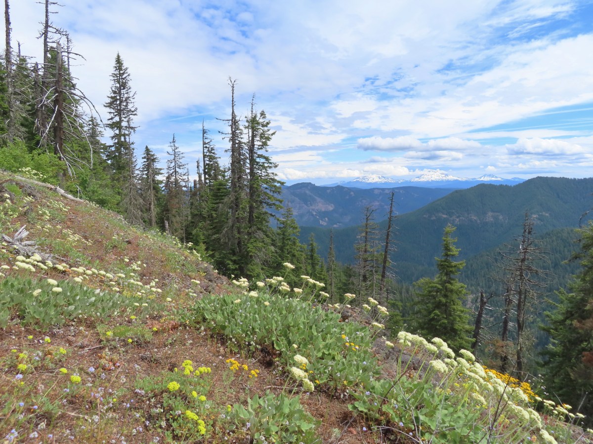

 Valerian along the trail.
 Vanilla leaf and anemones carpeting the forest floor.
 Star-flowered false solomonseal.
 Coneflower with lupine behind.
 Penstemon


 Monkeyflower
 Lupine
 Sub-alpine mariposa lily
 Moth on fleabane.
 Waterleaf
 Tiger lily
 Pussytoes
 From left to right the peaks with snow are: The Twins (
 Diamond Peak
 Grasshopper Mountain above the meadow.
 The post in the rocky area.
 When we visited in 2017 it had been mid-July, and the larkspur show was over.
 A cairn marks the Grasshopper Mountain Trail.

 Looking out over the meadow.
 Fuji Mountain and Diamond Peak
 The saddle below Grasshopper Mountain.
 The Three Sisters and Broken Top
 Mt. Bachelor
 The last of the snow, at least it is all we saw.
 Glacier lilies near the tiny snow patch.
 It was evident that the trail does get maintained on occasion, but none of it appeared recent near Grasshopper Mountain.
 Anemone
 Violets
 Bleeding heart
 Oregon bluebells
 The Three Sisters and Broken Top were visible from this area.
 Back on the slightly overgrown trail.
 Mt. Jefferson and Three Fingered Jack
 Bears appear to use the trail more than hikers. This was the largest of three piles we’d pass on the day.
 Arnica
 This is both the trail and a front (back) door.
 Valerian and tall bluebells
 Fairy bells
 Meadowrue
 Moth on valerian.
 Jacob’s-ladder
 While the trail was overgrown in places it was passable and the tread was in pretty good shape.
 Fringecup
 Possibly a speedwell but unsure and it was the only one we saw.
 More blowdown to maneuver around.
 Edith’s checkerspot
 Trail passing through an area full of monkeyflower and larkspur.
 Cinquefoil, larkspur, and buckwheat
 Scarlet gilia
 Paintbrush
 Bluehead gilia and silverleaf phacelia
 The rocky area from the trail as it crossed the ridge.
 Columbine crowding the trail.
 The wildflower covered rocks on the way back.
 Arrowleaf buckwheat and Oregon sunshine
 The Three Sisters and Broken Top with some clouds moving in.

 Paintbrush surrounded by buckwheat, bluehead gilia, and stonecrop.
 Scarlet gilia
 Wallflower
 Wild rose
 Beargrass near the outcrop.
 The outcrop from the trail.
 Blowdown
 More blowdown
 Western meadow fritillary
 Bunchberry
 Recent trail maintenance! There were a couple of cut trees in the final mile, but there were also still many to step over.
 The trail dropped low enough that there were several rhododendron blooming.
 Queen’s cup.
 South Sister (

 Had I not just come down the trail I might not have even noticed it was there.
 Cardwell’s penstemon
 Starflower
 Ginger
 Mt. Bachelor through the trees.
 Musk monkeyflower
 Grasshopper Mountain from the outcrop.
 Cliff beardtongue
 Blue-eyed Mary
 Cicada, not a pollinator but interesting to see.
 Solomonseal
 Variable-leaf collomia
 Oregon grape
 Pollinator 1
 Pollinator 2
 Pollinator 3 (Clodius parnassian)
 Bees on bastard toadflax
 Checkerspot on groundsel
 Penstemon
 Our guess is this is mile three from Grasshopper Saddle. We didn’t notice any other numbers and missed this one on our first pass.
 Dwarf bramble
 Strawberry
 Cinquefoil
 It started clouding up in the afternoon.
 Back at the saddle below Grasshopper Mountain.
 Great artic butterfly. There were a lot of these flying about. Their dorsum is a bright orange, but they rarely would open their wings when they landed.
 The checkerspots on the other hand are happy to open their wings.
 False hellebore
 It clouded up over Diamond Peak as well.
 Lewis flax
 A Lycaendae on a lupine leaf.
 Moth on a mariposa lily.
 Butterflies gathering at the spring.
 The Prius at the TH. We parked on the shoulder in a pullout.
