
After spending the night in Roseburg (post), we were finally headed to the Cow Creek Trail. There wasn’t much recent information online regarding trail conditions. The trail is an additional hike in the back of William L. Sullivan’s “100 Hikes/Travel Guide Southern Oregon”. It also doesn’t help that the Forest Service websites have been undergoing an update and trail information is basically non-existent at this point. VanMarmot’s Travels has the best write up on the trail, but his visit was back in 2018. There were a couple of brief write ups from 2023 & 2024 from outings that didn’t provide details, nor did they appear to have hiked the entire 6-mile trail.
Located about an hour SE of Roseburg, the Cow Creek Trailhead is not identified on Google Maps but there is a pit toilet and room for a number of cars.


The trail begins next to the East Fork Cow Creek next to a small memorial plaque.


The trail was pretty overgrown which was fine except for the fact that the previous day’s rain was still sitting on the leaves which quickly soaked us.

The trail climbed a bit and swung around a ridge leaving the East Fork Cow Creek drainage and entering the South Fork Cow Creek drainage.


Madia along the trail.

Madrone along the trail.
The trail then descended to the first of several bridgeless crossings of the South Fork Cow Creek.


We had brought our water shoes for the fords which we changed into even though our feet were damp from the wet vegetation anyway.

Shortly after crossing the creek we entered the 2021 Wildcat Fire scar which burned almost down to the creek.


Another overgrown section of the trail.


The first tricky obstacle we had to get through.


There were some big trees along the trail.
About a mile from the trailhead we came to the second ford of the creek. At this point we’d left the fire scar behind.

The trail is straight ahead on the far side.
We came to the third ford less than a quarter mile from the second.


Wildflowers in the trail.
The trail became even more overgrown beyond the third crossing.


Columbine and blowdown along the trail.


Twinflower

The trail here was completely covered by salal.

Rhododendron above the trail.


Pond along the trail.
The trail had climbed above the creek which helped with the amount of brush along the trail, but it presented new challenges with downed trees.


Wintergreen

Anemones

This section of downed trees required crawling under a few and over others.

I had gotten ahead of Heather and at approximately the 2.75-mile mark I came to a pair of large, downed trees that had caused a small slide on the far side of them. These could not be ducked under and in order to get over them I had to go between the two by bracing my left foot on the upper tree and then hoisting myself over the large lower tree.

I paused on the far side assessing the trail ahead while realizing that Heather’s legs aren’t long enough to make it over this obstacle as I did. Going below the trees wasn’t an option due to their length and the steepness of the hillside, and going around above them would have led through the small slide which didn’t seem like a safe choice. Then I looked back and realized that getting back over these trees from the side I was on was going to be even harder than getting over had been due to the angle of the trees. While there were no other visible obstacles ahead along the small portion of trail I could see I knew I was still over 3-miles from the upper end at Railroad Gap with no idea what the conditions ahead were. I decided to call it and work on figuring out a way back over the trees.
I was barely able to get my leg high enough onto the tree to pull myself over using the bark of the tree for a grip (good thing it didn’t come off). A couple of minutes later I met up with Heather and let her know about the obstacle ahead and we headed back to the car. While it was a little disappointing to turn back we would at least be getting home earlier than we’d expected.
We skipped the water shoes on the way back since fording the creek couldn’t add any more water to our shoes/socks and just enjoyed the scenery along the trail.

Pink pyrola

Northern phlox

Snail

Another look at the first major obstacle.

Pinesap

Tiger lily

Coral root dressed as vanilla leaf.


Since we had ended the hike early we decided to stop at the Cow Creek Falls Trail which we’d passed on the drive to this trailhead. Located across form the entrance to the Devil’s Flat Campground we parked near old Devil’s Flat Guard Station.

We followed a pointer for the Cow Creek Falls Trail to complete a 0.4-mile loop passing above Cow Creek Gorge.


Devil’s Flat Guard Station

Cow Creek Falls Trail


Tiger lilies
We came to an unsigned fork near a footbridge and correctly chose to turn left.

The right-hand fork just led back up to Cow Creek Road according to the GPS.

We had to keep an eye out for poison oak along this trail.

Cow Creek Gorge
 Cow Creek Gorge


Stable from the trail.
 Prince’s pine

Stonecrop
The loop led back up the Devil’s Flat near the old stable.


From the stables we followed a road back to our car near the Guard Station.


My 5.5-mile track at Cow Creek and our hike at Cow Creek Gorge.
The Cow Creek Trail was beautiful so it’s unfortunate that we weren’t able to hike the whole thing, but we enjoyed the portion that we could. Maybe the trail will see some maintenance, but that is becoming harder and harder with budget cuts and now the current administrations staffing cuts. Combine that with the possibility of public lands being sold off and the outlook is a little bleak. Knowing that things don’t last forever is one of the reasons that we have been trying to visit as many different trails as possible while we can. The other thing we can do is let our representatives know how important it is to keep our recreational lands open to the public. Happy Trails!
Flickr: Cow Creek Trail and Gorge


 Clearly the trail has been realigned based on where the map shows it is and where our track shows we were.


 There was a lot of white-stemmed frasera blooming which was exciting because we had been too early for the bloom when we were in the area Memorial Day Weekend (


 Please note that this campground is one of several that the Forest Service has contracted private concessionaires to manage and there is a $10.00/day parking fee for day-use. An annual NW Forest Pass is accepted in lieu of the fee but a single day NW Forest Pass and some interagency passes may not be. There is conflicting information online through the Forest Service website and what is posted at the trailhead.
 Signage at the trailhead still shows that a variety of passes are honored there but the link for the campground provided above only lists the annual NW Forest Pass as accepted.


 Clockwise provides the gentlest climbing for the loop which is the direction we were hiking so I went left.


 Mt. Adams between the trees.
 Larkspur


 Rosy pussytoes


 The pullout only has room for two cars, a third might be able to squeeze in but it would be tight. DO NOT drive past the gate if it happens to be open as motor vehicle use by the public is not allowed beyond the gate.


 A section of intact forest.


 False lily-of-the-valley


 Chipmunk


 Salmonberry


 Another junco


 Mt. Rainier


 Dandelion (non-native) in the penstemon. There were surprisingly few non-native wildflowers which was nice.

 Looking back after having made it onto the ridge. The loop route is the road seen on the right cutting along the hillside, not the roadbed straight ahead going up the knoll.


 Lomatium


 Small parking area at Wildwood Falls Park.


 We’ve found that the Forest Service seems to sometimes round milage shown on trail signs.


 We took a break in this rocky section of trail which was the only place we could find where the mosquitoes weren’t too plentiful. The lower portion of the trail had been fine but as we climbed the mosquitoes became more plentiful. While we were taking our break we heard the distinctive “meep” of a pika “meep”, but we weren’t able to spot any.


 Rough tread on the Marten Flume Trail.


 Dotted line is the current loop. Green is our track from 2016 and red is a part of our Brice Creek Hike in 2014.
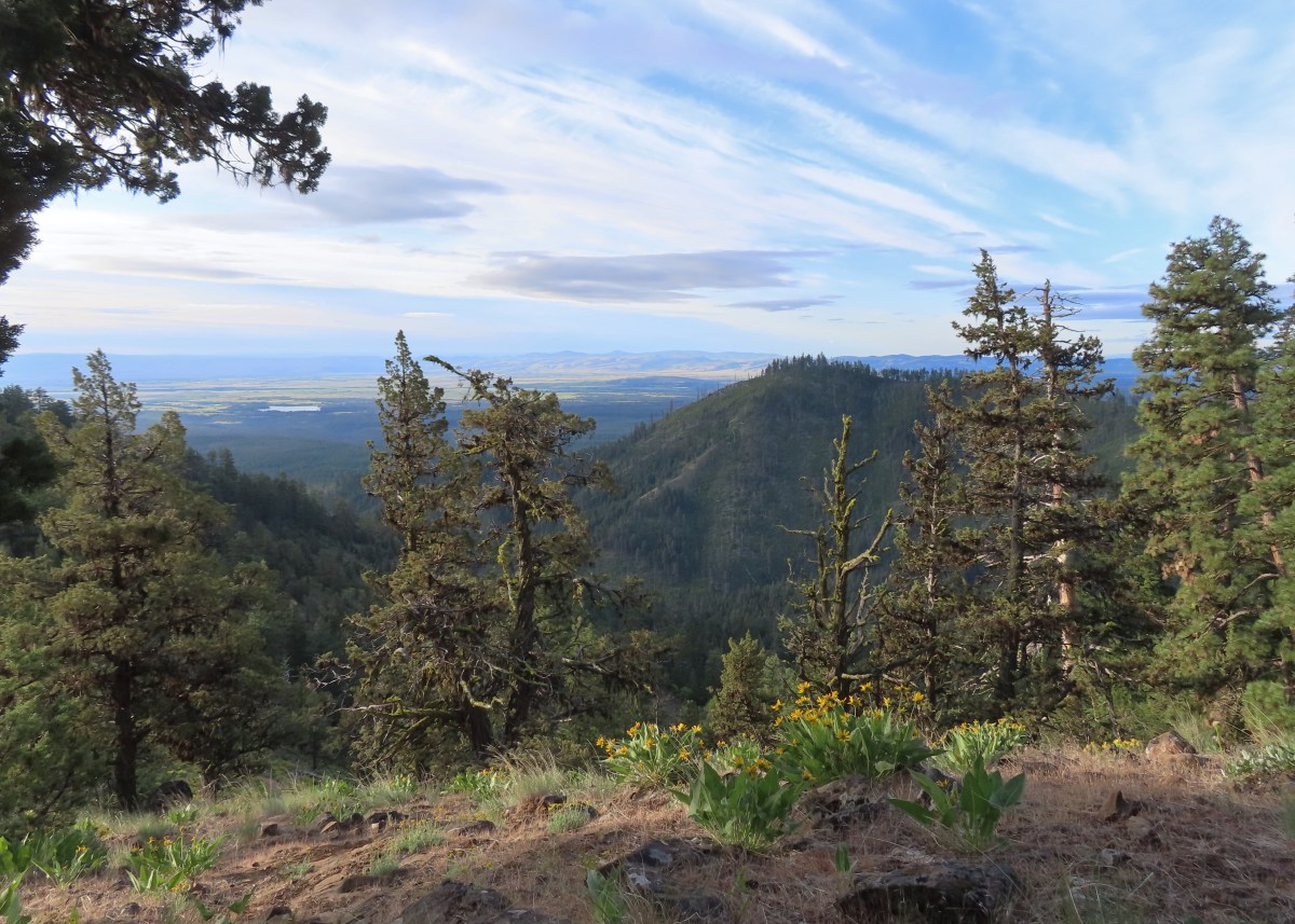
 The Tygh Creek Trail across FR 27 from the Tygh Creek Trailhead.
 The only two trees down that needed to be climbed under/over.
 Tygh Creek
 Distance + low light + moving animal = blurry photo.
 The skunk had been at the far end of this section of trail which was lined with lupine.
 The little stinker had a pretty cute face.
 The trail is to the right in this photo.
 Paintbrush, balsamroot, and a strawberry blossom.
 Ball Point
 Rough eyelashweed
 When a trail looks steep in a photo that tells you something.
 More paintbrush and balsamroot.
 Townsend’s solitaire
 Buckwheat
 My goal, the turn around point, was up on the crest of that ridge ahead.
 Lupine, balsamroot, and a death camas.
 Dogwood tree among the ponderosa pines.
 Mahala mat
 Getting close to the ridge and still steep.
 The trail got less steep near the ridge.
 Gordon Butte to the right. Broken Top, the Three Sisters, and Mt. Jefferson would also have been visible if not for the clouds.
 Level trail on the ridge!
 Looking ahead at the trees atop the “small” ridge.
 Sandwort
 Oregon sunshine
 Wildflowers on the “small” ridge.
 Almost to the crest.
 The clouds here are hiding Mt. Hood which should be visible behind the ridge. What is visible is Flag Point (
 Looking toward Mt. Jefferson.
 Parts of Mt. Jefferson peeking out through the clouds.
 I’d seen a couple whitestem frasera going up but coming down I realized just how many there actually were, although none of the plants were quite blooming yet.
 Groundsel
 Broken Top and some of the Three Sisters were visible on the way down.
 Tam McArthur Rim (
 I missed this whole patch of silvercrown earlier.
 Pine Hollow Reservoir and Central Oregon.
 Elkhorn clarkia aka ragged robin.
 Threadleaf phacelia
 Paintbrush with Ball Point in the background.
 Vetch
Vetch Penstemon
 Bastard toadflax
 Back in the forest near Tygh Creek.
 Tygh Creek
 Squirrel
 Starflower
 Coral fungus
 The trailhead in sight.
 The Tygh Creek track along with a portion of Saturday’s hike on the School Canyon Trail at the bottom.


 Phacelia
 Fleabane
 Thistle
 Madia
Madia
 Fiddleneck and lupine
 The first of several deer we spotted during the day.
 The distinctive cliffs behind the lupine are across the river from the parking area so we were almost always able to tell where we had parked.
 This jeep track would veer to the left to pass between the smaller hills and cliffs ahead.
 Western meadowlarks could be heard throughout the hike.
 The view south.
 Desert yellow fleabane
 The view west.
 Mt. Hood peaking over the canyon rim to the NW.
 Mt. Hood
 Butterfly on yarrow
 Grasses and wildflowers added color to the landscape.
 The route became very faint at times.
 Balsamroot
 Looking back at the route so far.
 View from the trail after passing between the hills and cliffs.
 An old fence.
 Mt. Hood and Lookout Mountain (

 Buckwheat

 Rough eyelashweed
 Paintbrush


 Another stretch of faint tread.
 It was often easier to see the road ahead than below our feet.
 Balsamroot and lupine
 Grand collomia and lupine.
 Spreading dogbane
 Digging in.
 Small water trough (empty).
 View from the water trough.
 Haven’t identified this bird yet.
 Looking back at the route again.
 Mt. Hood again.
 Ochre ringlet. There were hundreds of butterflies.
 Looking at the climb ahead. At this point most of the rest of the hike would be in direct sunlight, and it was already getting warm.
 Buck
Buck Buck number two.
 We had to get pretty high up before we could see Washington’s Mt. Adams and even once it was in view the lighting made it hard to make out.
 Mt. Adams
 The newer barbed wire fence at the public land boundary. This is around 3.5-miles from the parking area.
 Hawksbeard
 The fence went up and down steeply so that meant we got to as well.
 Crow
Crow Fritillary
 Cattle trail
 Western kingbirds
 A milkvetch
 Another butterfly on balsamroot.
 Stag Point is the high triangular point along the plateau in the foreground.
 Zoom in on Stag Point. (The lone post on top gives it away.)
 First and only brief view of the top of Mt. Jefferson.
 Mt. Jefferson
 The newer fence turned left at the corner.
 Onion
Onion This rocky gully was a little tricky to cross.
 Checkerspot
 Old stone structure along the fence.
 Western meadowlark
 Lark sparrow
 Probably cattle bones.
 Checkerspot on fiddleneck.
 Balsamroot and Mt. Hood from the road.
 Phlox
Phlox Indra swallowtail
 Checkerspot
 Another checkerspot
 A blue or copper of some sort.
 Oregon sunshine
 Skipper
 Colorful rocks
 Looking back up along the switchback section.
 Gate along the road at the end of the switchbacks.
 Allumroot

 Cusick’s sunflowers and desert yellow fleabane.
 Cusick’s sunflowers
 Looking back up the road toward the snake.
 The still coiled snake to the right of the track.
 The fainter jeep track split off here to the right. It’s really hard to see it in the photo but was a little more obvious in person.
 The goal was to aim for the knoll ahead then find two junipers that were relatively close together and descend between them.
 Looking back up from the jeep track.
 The view upriver with a private house.
 Going between the two junipers.
 Looking back up at the two junipers.
 It’s a checkerboard of public and private land along the road. While this portion of the road is open to hikers, public fishing along the riverbank is limited to the public land portions. No trespassing signs line the road in the private sections.
 Heather spotted this rattlesnake off the side of the road. We couldn’t tell if it was still alive and didn’t really want to find out.
 One of the few bits of shade along the road walk.
 Probably some sort of flycatcher.
 There were a lot of osprey along the river.
 There were also quite a few Bullock’s orioles.
 Mock orange along the river.
 Mallard
 Bindweed
 Another unknown bird and an angler in the river.
 Cliff swallow
 Dove
Dove More osprey
 Portland Deschutes Club Gatekeepers House

 Geese
Geese Common merganser
 Yarrow covered hillside.
 Rock formations above the road.
 The distinctive cliffs on the opposite side of the river from the parking area.
 Arriving back at the parking area.
 Yellow is our track from 2023.
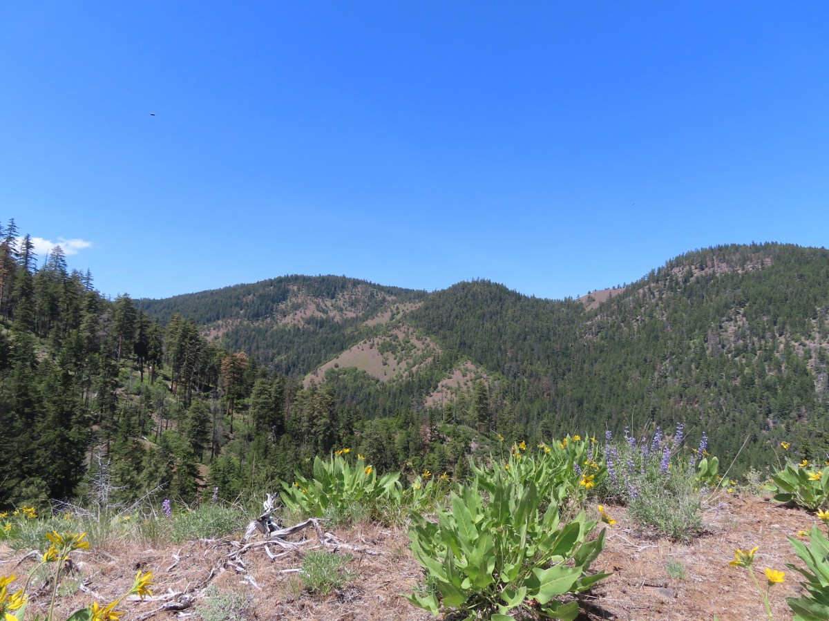


 We headed off through the trees here.
 Mt. Jefferson and Olallie Butte (
 Gordon Butte in the foreground.
 Balsamroot and oak trees.
 Buckwheat and balsamroot
 Whitestem frasera with Mt. Jefferson in the background.
 Rough eyelashweed
 Paintbrush
 We picked up a faint path, not sure if it was a game or use trail.
 Lupine and ponderosa pines.
 The trailhead is on the opposite side of FR 2710 from the trail.
 Sign at the start of the Little Badger Trail.
 Badger Creek Wilderness sign next to Little Badger Creek.
 Groundsel
 Woodland stars
 Little Badger Creek
 Fairy slipper
 American vetch
 Bastard toadflax
 Duskywing on sagebrush false dandelion.
 Balsamroot
 Bee coming in for a landing on phacelia.
 Sticky cinquefoil
 Western wood-pewee
 Madia
Madia Brown elfin (and another pollinator) on Oregon sunshine.
 Starflower
 Mahala mat along the trail.
 Duskywing on blue-eyed Mary
 Largeleaf sandwort along the trail.
 Skunk cabbage
 Red-flowering currant
 Duskywing on arnica
 Silvercrown
 Oregon grape
 Last of the trillium.
 Plumed solomonseal
 What’s left of the cabin.
 Little Badger Creek at the cabin site.
 Anemone
 There was a short climb before reaching the spur trail.
 Spur trail to the mine.
 The old mine. We did not go in as wildlife do sometimes use it for shelter.
 Ballhead waterleaf near the mine.
 Western tanager
 A stand of oaks ahead.
 Balsamroot along the trail.
 Paintbrush
 Buckwheat
 Juniper trees
 Threadleaf phacelia


 Signpost ahead for the trail junction.
 Wildflowers along the trail.
 The spur trail on the left to the Helispot.
 Penstemon

 Pine Hollow Reservoir in Central Oregon.

 Woodland star
 This was the most significant obstacle we had to navigate on the entire loop.
 Yarrow
 A dogwood on top of the rocks and penstemon below.
 First view of Ball Point.
 Penstemon
 From the ridge we could faintly make out Broken Top and the Three Sisters.
 The Three Sisters on the right and Broken Top with Tam McArthur Rim (
 Pen Point across the Tygh Creek Valley.
 Passing through the 2009 Ball Point Fire scar.
 Pen Point toward the center and the taller Hootnanny Point to the right.
 Death camas
 View east as we came around Ball Point.
 Desert yellow fleabane.
 Prairie smoke aka Old Man’s Whiskers


 Heather coming down the ridge.
 I think this is a western racer.
 Looking up at the ridge.
 A clarkia
 Lewis’ woodpecker
 Lizard


 On last view of Mt. Jefferson
 Ball Point
 Butterfly on whitestem frasera
 Signs at the trailhead.
 Orange is the road + cross country portion.
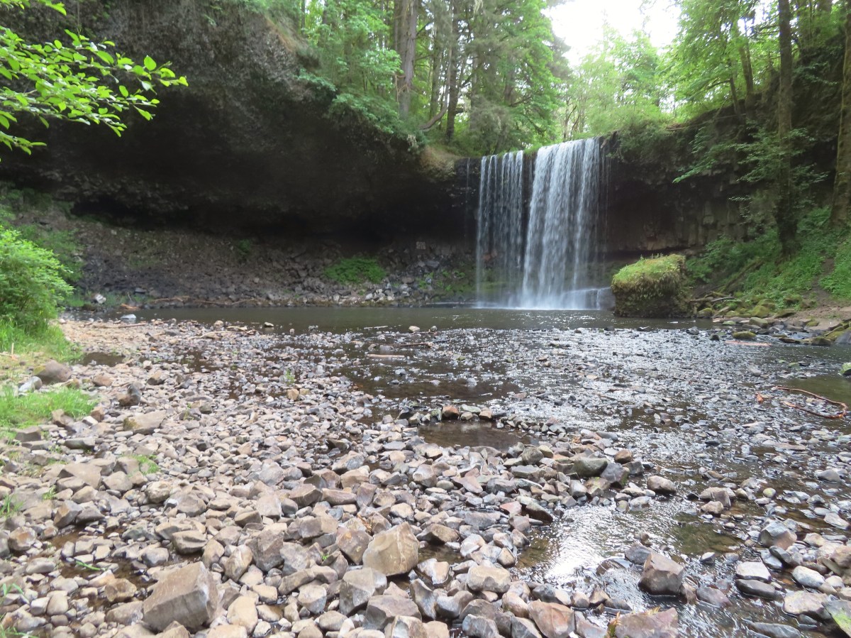

 There were a couple of downed trees and at least one spot where part of the tread had given way on the hillside. A bigger issue was the broken glass and other garbage left by mouth breathers that was littered about.
 It was just over a third of a mile to the falls.
 Beaver Creek below the falls.
 Trail snail
 Fringecup
 Starflower


 Fairy lanterns
 Scouler’s corydalis
 Bleeding heart
 False lily of the valley
 Highway 30 crossing.
 Sign along the section of trail between the highway and the fish hatchery.
 Trail pointer on the shelter at the fish hatchery.
 Youth-on-age
 Numbering on a tree for the interpretive trails.

 Bigfoot off the Gnat Creek Trail.
 Trillium
 Huckleberry blossoms and a downed tree along the Gnat Creek Trail.
 Scouler’s corydalis along the trail.
 The start of the short loop.
 One of two benches along the loop.
 Gnat Creek from the bench.
 The backside of the loop was a little overgrown.
 Star-flowered Solomonseal
 We mostly stayed right at junctions to keep along the creek.

 Barrier Falls

 Unnamed waterfall near the hatchery trailhead.


