
Snow returned to Cascades earlier in the week with the white stuff falling at elevations down to 4000′. While it didn’t stick around on the roads, we suspected enough snow fell for there to be some on the forest floor at lower elevations heading into the weekend. We tested our hypothesis by driving Highway 58 to Forest Road 5897 (Waldo Lake Road) for a pair 5+ mile hikes.
Our first stop was for the Marilyn Lakes Trail. There are several potential starting points for the hike to these two lakes. Hike Oregon recommends starting at the Gold Lake Sno Park for cross-country skiing or snowshoeing in the Winter. Sullivan recommends starting at the Gold Lake Campground for the hike. (Gold Lake Road, aka FR 500, to the campground would be inaccessible due to snow in Winter.) We however chose to begin off of FR 5897 at a small pullout on the right just under 2-miles from Highway 58 where a pair of small signs marked a ski trail.
 The pointer is for Gold Lake & Highway 58.
 The pullout along FR 5897.
We set off on this trail and quickly came to the junction with the Gold Lake Trail where we turned right.
 We were pleased to find that there was more snow left than we’d expected.
 Coming up on the Gold Lake Trail.
 Trail signs at this well marked junction.

The Gold Lake Trail lost a little elevation as it descended for 0.2-miles to a parking area at the end of FR 500.
 Campsites on the right at the Gold Lake Campground.
 Looking back up the Gold Lake Trail.
We walked up FR 500 and crossed Salt Creek.

 Downstream several miles Salt Creek flows over Salt Creek Falls (post).
On the far side of Salt Creek was the day use area (and start of the Marilyn Lakes Trail) to the right and the Gold Lake Shelter on the left.


 Signs ahead for the Marilyn Lakes Trail.
The trail was a bit overgrown in spots but being a ski trail there were plenty of blue diamonds to help keep us on the right path.


After 0.4-miles we came to a junction where we turned right following a pointer for Marilyn Lakes.

 The left-hand fork led up to FR 500. We took this fork on our way back.
 Heading toward the lakes.
We came to a second junction in just 400′.
 The right-hand fork is the start of the Lower Marilyn Lakes Trail.
We went right again and in another 400′ got our first glimpses of Lower Marilyn Lake.


The trail followed the lake for a third of a mile providing a couple of nice views.

 Lower Marilyn Lake

The trail veered away from Lower Marilyn Lake and passed the SW end of Upper Marilyn Lake in an overgrown meadow. It was clear that the area between the lakes would be extremely wet/boggy in late Spring/early Summer. Mosquitos are a real problem that time of year throughout the Waldo Lake area making it a less-than-ideal time for a visit.
 A lot of downed trees had been logged out.

 We lost the trail briefly in this area and simply headed for the diamond in the distance.
 Upper Marilyn Lake

Beyond the upper lake the trail gained 200′ of elevation to reach a small parking area off FR 500.

 Canada jay
 The cold air and moisture started fogging up my camera lens.
 The trail got very overgrown just before reaching the road. We were pretty damp after passing through this mass of huckleberries.

We turned left onto FR 500 and followed it just over three quarters of a mile to a short spur on the left that led to another signed parking area.


We picked the trail back up here and followed it downhill a quarter of a mile to Upper Marilyn Lake.

 Not sure what is going on with this mushroom.

 A bald eagle was circling over the lake hoping to catch a fish for breakfast.
We watched the eagle for quite a while. It swooped twice but came up empty both times.

I had about as much success getting a picture of the eagle in flight as it had fishing.
After watching the eagle for quite a while we continued on the trail which followed the lakeshore.


 Common mergansers
 Diamond Peak (post)
 Diamond Peak and Mt. Yoran with a few of the mergansers flying overhead.
The best views of Diamond Peak were found near the northern end of the upper lake.


 The eagle was now watching us.


A tenth of a mile beyond the lake we found ourselves back at the second junction we’d come to. We turned right and made our way back to the first junction.

 We went straight here this time and followed this trail 0.4-miles to FR 500.


We turned left again on FR 500 and followed it a third of a mile to the Gold Lake Campground.

After crossing over Salt Creek we detoured to the right to visit Gold Lake before returning to the car. This was a 5.4-mile hike with approximately 300′ of elevation gain.
 Gold Lake

We got in the car and drove another 3.5-miles up FR 5897 to the large Betty Lake Trailhead on the left.
 More fogging on the lens.

The Betty Lake Trail began with a slight downhill to cross a dry creek bed then climbed briefly to a wide saddle before dropping to Betty Lake.
 The dry creek bed ahead.

At an unmarked but obvious fork we veered left to visit the lake shore.

 Bear tracks. We weren’t the only visitors to the shoreline.

We followed this use trail along the lake for a while before heading uphill to rejoin the official trail.
 Mount Ray

The trail made another brief climb through the forest before beginning a gradual descent past a series of smaller lakes before arriving at a junction with the Jim Weaver Loop.


 Howkum Lake on our left was the first lake we passed by.
 Reflection in Howkum Lake.
 Nearing the second lake on the left, Horsefly Lake.
 Horsefly Lake
The third lake, Tiny Lake, was just off the trail to the right.

 Tiny Lake


 The junction with the Jim Weaver Loop was next to a small unnamed lake.
We turned left onto the Jim Weaver Loop passing the unnamed lake and following the trail four tenths of a mile to another junction near the shore of Waldo Lake.


 A different bear had been wandering around this area.
 We could tell it was a different bear because the prints were noticeably larger. (11 1/2 shoe size for reference.)

 Signs at the junction.
We had passed this junction in 2015 during a lollipop loop into the Waldo Lake Wilderness. We started that hike from the Shadow Bay Day Use Area and used the Shadow Bay Shoreline Trail to reach the Jim Weaver Trail. There wasn’t a clear view of Waldo Lake from the junction, so we headed left on the Jim Weaver Loop to find a spot where we could access the rocky shore.
 View from the junction.
 I dropped down to the shore on the other side of this footbridge.

 The longer hump to the right in the distance is Waldo Mountain (post). The west side of the lake and the wilderness were heavily burned in the 2022 Cedar Creek Fire.
 Fuji Mountain (post) is just barely visible over the left shoulder of hump in the foreground.
After getting an unobstructed view we headed back. It was a pretty uneventful return. We dropped down to Betty Lake to hike the use trail along the shoreline instead of staying up in the forest.
 Tree reflecting in snowmelt.
 Betty Lake had some nice coloration.
 Mount Ray from Betty Lake again.
There were about a half dozen cars at the trailhead when we got back, but we hadn’t passed anyone on the trails during either of our hikes. There had been a family loading up their car when we first arrived at this trailhead and one occupied campsite at the Gold Lake Campground, but the hikes themselves had offered solitude.
The hike to Waldo Lake and back came in at 5.3-miles with approximately 450′ of elevation gain which was very similar to the Marilyn Lakes stop.

This brought the days total to 10.7-miles and around 750′ of elevation gain.
 A look at the two hikes proximity to each other.
Longer or shorter hikes could be done from either trailhead. With a number of other trailheads in the area as well it’s no wonder the Waldo Lake area is a popular destination. This was our seventh visit to the area and there are still many miles of trails we’ve yet to be on. Happy Trails!
Flickr: Marilyn and Betty Lakes

 Featured hike starting locations. Blue = OR Coast, Red = NW, Black = Central Cascades, Purple = Southern OR, Yellow = Eastern OR
 Hunting information kiosk across from the Turtle Flats parking area.
 The Turtle Flats restrooms. (Photo from the afternoon.)
 The entire Turtle Flats Trail in one photo.
 Viewpoint at the end of the trail.


 I turned right here following said map through a small section of trees.
 Poison oak is hard to miss when it is sporting its Fall colors.
 Emerging from the trees and staying right.

 McCulloch Peak (
 Mary’s Peak (
 One of several raptors hunting over the fields.
 Pigeon Butte to the left and Green Peak in the distance.

 Fog and McFadden Marsh to the left.
 Mallards
 Geese flying overhead.
 Egret and ducks
 Egrets
 More egrets
 Heron with the egrets.
 McFadden Marsh
 Egrets and a murder of crows.
 Great blue heron
 Red-winged blackbird
 Prairie Trail along McFadden Marsh.
 I could just make out the railings along Bruce Road from here.
 Nutria family near Bruce Road.
 The nutria family.
 The Prairie Trail at Bruce Road.
 Northern flicker
 Starling
 Muddy Creek
 Interpretive signs at the larger parking area.

 California scrub-jay
 Peregrine falcon?
 Pigeon Butte across Cheadle Marsh.
 While I was photographing this egret I glanced to my left and noticed a buck staring back at me.
 Meanwhile a great blue heron decided it wanted the egret’s perch.
 The heron and egret
 American coot
 The roof of the Cheadle Barn poking up from the hill.
 California quail escaping into the blackberry bushes.
 The small hill up to the junction below the barn. My legs let me know that even this small hill was more than they were interested in today.
 Robin
Robin Spur trail to the Cheadle Barn.
 Spotted towhee
 The pond and Cheadle Barn.
 Ducks in the pond.
 Pied-billed grebe. I also had a yellow-rumped warbler nearly land on me, but then it disappeared into the trees across the pond.
 The gravel road that serves as the Pigeon Butte Trail ahead.
 A successful egret and unfortunate rodent.
 The junction is located at the crest of the trail/road.
 Spur trail to the summit of Pigeon Butte.

 The dry ponds hosted a good number of songbirds.
 It appeared that there had been a number of controlled burns performed throughout the refuge.
 The 0.9-mile section ended at a junction with the Cattail Pond Trail.
 Viewpoint bench looking toward Cabell Marsh.
 Woolly bear caterpillar sharing the trail.
 Gray Creek
 Mallards
 More mallards
 Maple Knoll on the far side of Cattail Pond.
 I’m assuming nutria but am not 100% convinced on this one.
 This section was a mixture of the edge of fields and wooded trail.
 Follow the pointer.
 A cedar waxing joined by a pair of finches.

 I turned right at this sign onto the Beaver Pond Trail and followed it a half mile back to the gravel roadbed.
 Just under 100 yards from the Cattail Pond Trail is this unsigned junction. The left is a half mile out-and-back spur on along the side of Maple Knoll. I stayed right this time having done the spur in 2020 with Heather.
 The trail passes the Beaver Pond just before arriving at the roadbed.
 The Beaver Pond was pretty well deserted given its lack of water.
 I turned left onto the Mid-Refuge Connecting Trail.
 Authorized personnel only on the right-hand fork here.
 Arriving at the junction.
 The right fork is the trail I came up. The center fork is the Mill Hill Trail, and the left fork is the Mill Hill Loop Trail which loops around Mill Hill in 1.7-miles and arrives back at the junction where I took this photo from.
 There are several junctions along this stretch, most of which are well signed.
 This junction marks the start of the Intertie Trail.
 Crossing Finley Refuge Road.


 Signage at the Woodpecker Hill Loop.
 The Woodpecker Hill Loop is a well-developed interpretive trail.
 Stellar’s jay
 Each of these kiosks has an informational placard inside.
 Near the crest of the trail.
 The shelter on Woodpecker Hill.
 Dragon fly
 Signboard at the Woodpecker Hill Trailhead.
 Yay, more uphill.
 The back of a killdeer.
 Bald Hill on the left.
 Winkle Butte is the near rise on the left. On a clearer day Mt. Jefferson would be visible in the distance to the right of Winkle Butte.
 Cabell Barn ahead.
 Historic granary
 The lodge in April, 2021.


 Geese
Geese Pigeon Butte from the marsh.
 Great blue heron towering over the ducks.
 An egret along the shore to the right.
 The egret facing off with the heron. The mallard appeared to be ready to act as the referee.
 After a brief face off the egret moved on.
 Observation blind accessed via the Homer Campbell Boardwalk.

 Signboard at the boardwalk trailhead.
 Back on the refuge road.
 Muddy Creek
 The path to Turtle Flats on the left and the start of the Prairie Trail ahead on the right.

 This trail would eventually end at the LoneWolf/Patterson Mountain Trail (
 The small trailhead along Highway 58.
 Wrong way dummy.
 The South Willamette Trail to the right.

 It was clear that mountain bikers use this trail regularly.


 I actually waited until I was on my way down to step off trail and look at the arch.
 Eula Ridge Trail sign at the Hardesty Trail junction.
 The lefthand fork leads to the viewless summit while the right is the Hardesty Cutoff Trail which bypasses the summit.
 Forest below the Hardesty Cutoff Trail.
 The Sawtooth Trail dropping to the right.
 I was not looking forward to climbing back up some of these sections later.
 Another saddle.
 A view through the trees.
 I passed the Hardesty Way Trail 1.5-miles from the Hardesty Cutoff Trail.
 Mount June from the hillside.
 Wallflower
 Junction with the Lost Creek Trail.
 The pointer for Eagles Rest (
 I called this section “rhododendron ridge”.
 The Mt. June Trail coming up from the right.


 If you look closely, you can see the tops of the Three Sisters poking up over the smoke in the distance. The open hillside in the foreground is the meadow below Sawtooth Rock and the hump just behind is Hardesty Mountain.
 Heading down from the summit.
 Climbing the hillside below Sawtooth Rock.
 Sawtooth Rock
 There was just a little smoke now and then in the forest.
 The Eula Ridge Trail coming into view.
 There wasn’t much in the way of Fall colors along the trail, but these leaves really stood out.
 Lookout Point Lake (Middle Fork Willamette River) from the trail.
 There was one more small uphill on the far side of South Creek before dropping to the trailhead.
 South Creek

 Not having light until after 7am is rough for someone who likes to get an early start.
 The Salmon River Trail is located next to this interpretive sign near the trailhead.
 A flash was necessary as I set off.
 There was a very brief road walk along this section.
 There was also plenty of time along the Salmon River.
 I veered right at this picnic table to cross into the campground.
 The day use area at the campground.
 Water spigot at the day use area.
 It was hard to read the date for this cougar sighting, it appeared to be from June, but I couldn’t make out the year.
 Entering the Salmon-Huckleberry Wilderness
 One of the downed trees, this one covered both sides of a switchback.
 A rare viewpoint along the forested trail.
 A level stretch along a narrow ridge.
 A healthy looking paintbrush.
 The Sun rising above Hunchback Ridge.
 It was going to a be a bluebird day.
 Sign ahead marking the Hunchback Trail junction.

 One of the “downs”.
 This trail was also in good shape with just a few easy obstacles.
 I did not go investigate the source of the “water”, it could have been a trap (there is a spring shown on the map).
 Signs at the junction below Devil’s Peak.
 Mount Jefferson
 Olallie Butte (
 The lookout from the Mt. Jefferson viewpoint.
 Mt. Hood from the lookout.
 You can’t see Mt. Jefferson from the lookout due to trees.
 Trail signs at the Cool Creek Trail junction.
 Lookout Mountain(
 Mt. Hood from the Hunchback Trail.
 Arriving at the trailhead on FR 2613.
 It’s hard to make out in the photo but that is a giant pothole (crater) in the middle of the road seen from the trailhead.
 That is the trailhead at the end of the road on the right.


 There were some nice Fall colors along the Kinzel Lake Trail.
 There were also a few obstacles that were trickier than anything on the other trails involved in this loop.
 Salmon Butte (
 Nearing the Salmon River Trail.
 Trail sign at the Salmon River Trail junction.

 There wasn’t much water at all in any of the side creeks.
 There are several viewpoints just over 3.5-miles from the trailhead.
 The furtherst hump in the center is Huckleberry Mountain (
 Wilderness kiosk along the trail. There were self-issued permits here, but none at Green Canyon Way so I stopped and filled one out even though I was almost done with my hike (and out of the wilderness).

 Salmon River
 There were a couple of good-sized fish in the pool here.
 The trail arriving back at the trailhead.
 We had also parked here in 2021 for our Barlow Butte hike (


 The colors of Fall.
 Tom, Dick, and Harry Mountain (
 Mt. Hood teased an appearance a couple of times along the lower portion of the PCT. It was enough to see that there was a dusting of fresh snow on the mountain.
 The signed junction with the Yellowjacket Trail.
 The wet brush had me whishing I’d worn boots.
 The Yellowjacket Trail passing a small meadow.
 Makeshift footbridge along the trail.


 New snow on Mt. Hood.
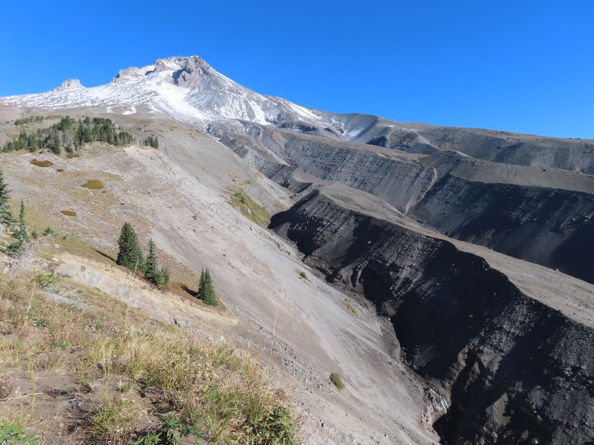
 The valley is the result of an eruption around 250 years ago.
 Pacific lupine
 At the end of the levee the route climbed a moraine then continued its gradual ascent to the Timberline Trail.
 Dark-eyed junco. There was a good variety of birds along the moraine, but this was the only one that sat still long enough to have its picture taken.
 Frost on a log. It was really nice to be hiking in the crisp cool air.
 Boy Scout Ridge from the moraine.
 The unsigned junction with the Timberline Trail.
 Mt. Hood from the junction.
 Sign for the PCT nearly absorbed by the tree.
 Lupine (broadleaf?)
 A few remaining blooms on the goldenrod.
 Signpost at the PCT junction ahead.


 The coyote with Mt. Hood looming behind.
 Mt. Jefferson to the south with the Three Sisters behind to the left.
 The Three Sisters and Mt. Jefferson
 The round peak along the far ridge is Gunsight Butte (
 We’d lost sight of the coyote until it ran across the trail not too far in front of us.
 More lupine
 A few remaining aster blossoms in the foreground.
 Timberline Lodge across the Salmon River Canyon.
 Looking back down the White River Valley. Barlow Ridge is the near hump on the right.
 Another look at Timberline Lodge.
 Despite all the cars at the lodge we would only encounter a half dozen other trail users until we were back at the Barlow Pass Trailhead.
 Small waterfall below the ridge.
 I turned around here where the Timberline Trail headed across the Salmon River drainage. The Silcox Hut is straight ahead on the side of the mountain.
 Looking back at the high point where Heather had stopped.
 Mt. Hood’s summit.
 The waterfall looking pretty small far below the mountain.
 It took us a moment to decide what the dark rounded peak straight ahead in the distance was. We eventually correctly identified it as Black Butte (
 Olallie Butte (
 Birds on mountain ash.
 The Timberline Trail junction.
 Beargrass meadow, there hadn’t been any blooms this year.
 Lousewort
 It was nearly 2-miles between the Timberline and Yellowjacket trail junctions.
 We were shocked to see a bunchberry that still had some petals, even if they were in sad shape.
 Mushrooms and fungi are not surprising this time of year.
 Highway 35
 Arriving at the Barlow Road.
 Our various hikes around the mountain. There are still a few areas where we could add a track or two. Happy Trails!