Categories
High Cascades Hiking Oregon Trip report Waldo Lake Area

Charlton and Lily Lakes Loop – 09/27/2025

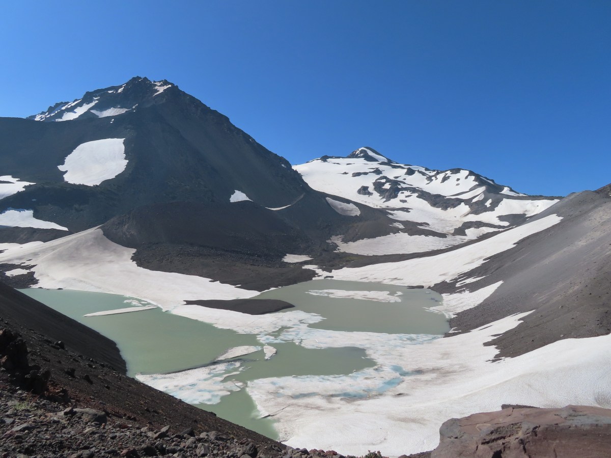
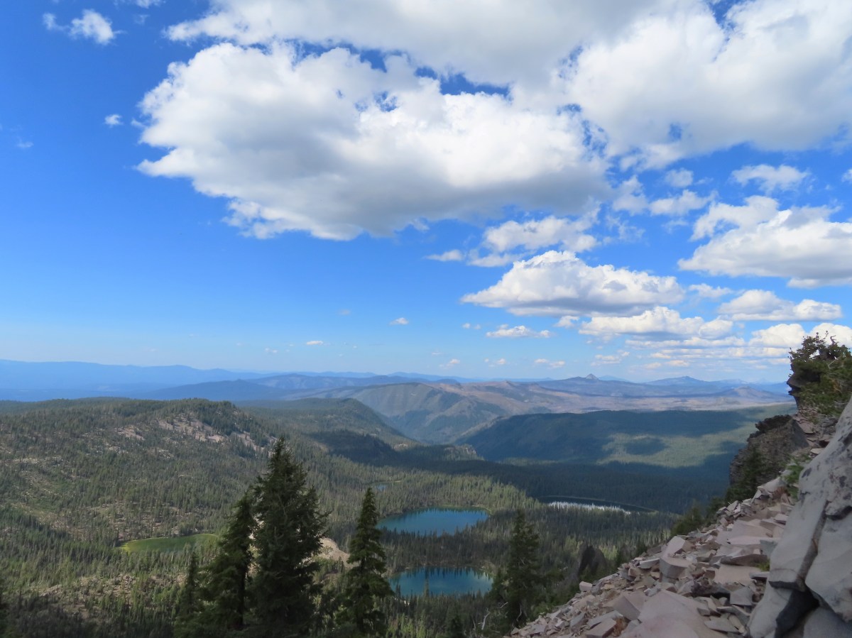
Another warm, sunny forecast coincided with our hiking schedule leaving multiple destinations possible. (My original schedule for the year has been largely replaced by groups of ideas depending on the weather or fire situation.) After considering several different hikes we decided to try out a loop around Charlton and Lily Lakes in the Willamette and Deschutes National Forests.

We parked at what Google labels as the Pct Trailhead located a quarter mile up Forest Road 4290 off Forest Road 5897 aka Waldo Lake Road.
IMG_1649

The first part of the loop we were planning passes through the 2022 Cedar Creek Fire scar. One of the trails, the Lily Lake Trail, was severely impacted by both that fire and the 1996 Charlton Fire and no longer shows up on the Forest Service website or updated maps such as CalTopo. Our paper, GPS, and the PCTA online map National Forest System Trails layer all showed the trail alignment, so we hoped that we would be able to use our navigational skills on that section.

Before starting the loop we headed down to Charlton Lake for a first look.
IMG_1652
Canada jay

IMG_1656
The trail to Charlton Lake from the trailhead crosses the Pacific Crest Trail (PCT) after just 250′ then continues to the lake for a total of just a tenth of a mile.
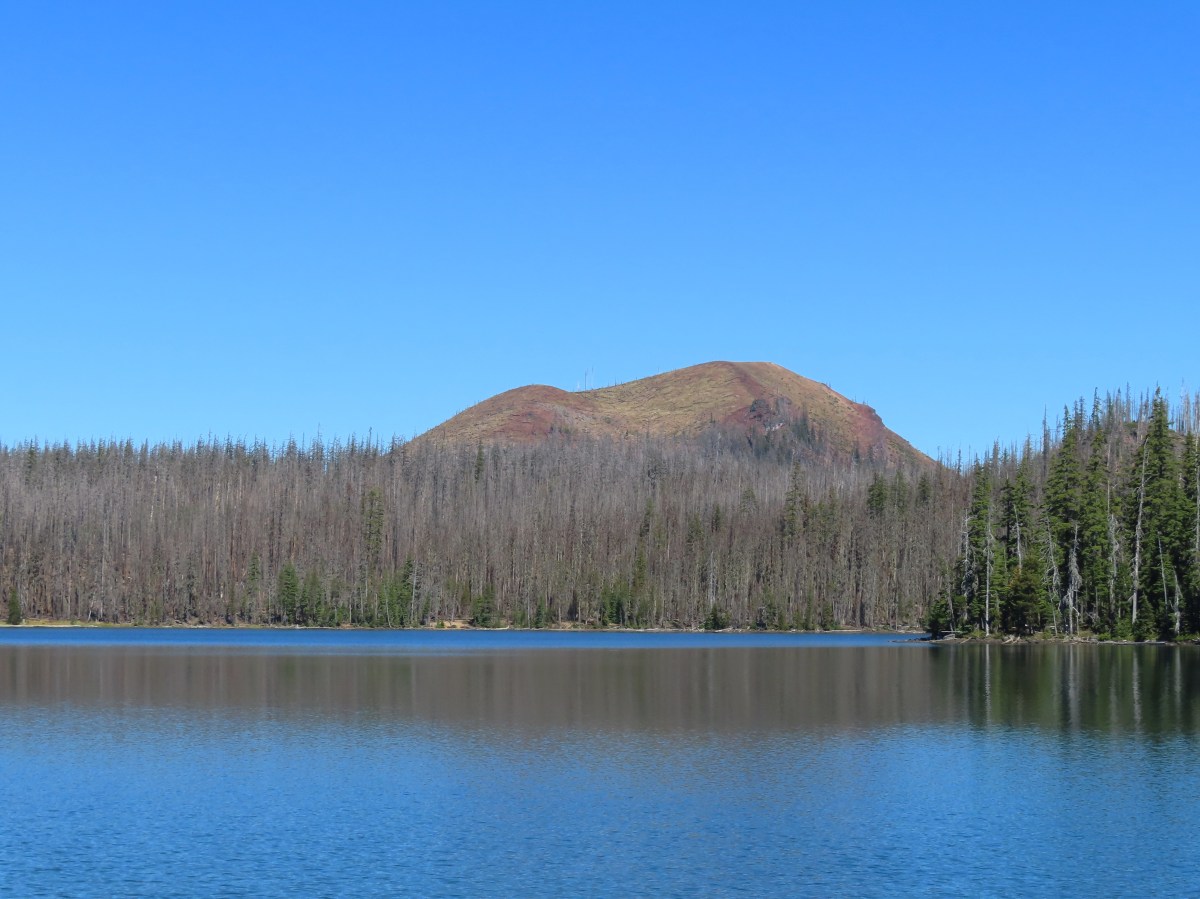
IMG_1660
Charlton Lake

IMG_1658
Geradine Butte to the left and The Twins (post) to the right.

After visiting the lake we hiked back to the PCT and turned right (north) heading toward the Lily Lake Trail junction.
IMG_1664

IMG_1661
Fireweed

After 0.4-miles on the PCT the trail crossed FR 4290.
IMG_1668

IMG_1669
We took it as a good sign that the Lily Lake Trail was listed on the sign at least.

The PCT headed toward Charlton Butte which it would pass to the west. The Cedar Creek fire had burned over this entire section although a few trees were spared here and there.
IMG_1671

IMG_1672

IMG_1676
Pond along the PCT.

IMG_1679
Charlton Butte

IMG_1683
Pearly everlasting

IMG_1685
Trail signs at the Lily Lake Trail junction. From FR 4290 the sign said it was 1.5-miles, the GPS put it at 1.4.

IMG_1686
It appeared this sign was set up after the 2022 fire so we took the inclusion of the Lily Lake Trail as another good sign.

We turned right onto the faint but discernable Lily Lake Trail and followed it up a small rise along the base of Charlton Butte gaining a view north of several Cascade Volcanos.
IMG_1689

IMG_1691
Irish Mountain is the forested peak to the left with Mt. Jefferson, Mt. Washington, The Husband, the Three Sisters, Broken Top, Mt. Bachelor and finally Cultus Mountain.

IMG_1694
Zoomed in you can see Three Fingered Jack in front of Mt. Jefferson. Little Roundtop Mountain is the peak between Mt. Jefferson and Mt. Washington.

IMG_1695
The Three Sisters

IMG_1696
Broken Top and Ball Butte

IMG_1697
Mt. Bachelor (post) and Kwolh Butte

IMG_1701
The flank of Charlton Butte.

The maps that contained the Lily Lake Trail showed it dropping into the basin below then swinging to the NE before arriving at Lily Lake. We quickly lost the tread at the lip of the basin and wound up using our GPS units to stick as close to the trail shown on those as we could.
IMG_1702
We found no sign of the trail at all going down the burned hillside. The footing was pretty good, but we had to be careful of holes or areas where the ground was not stable.

As we got closer to the basin the severity of the burn was less which meant more obstacles to navigate.
IMG_1703

We continued to use the GPS units as guides and eventually found what appeared to be the former trail tread.
IMG_1704
What is left of the Lily Lake Trail coming through the basin.

IMG_1705
The Lily Lake Trail heading toward the lake.

IMG_1707
Charlton Butte from the trail.

IMG_1709
Arriving at Lily Lake just under a mile from the junction with the PCT.

Unlike Charlton Lake where much of the forest around that lake had survived the Cedar Creek Fire, all of the forest surrounding Lily Lake was burned.
IMG_1710

IMG_1716

The good news was that the trail tread was much more obvious as it passed along the southern end of the lake for a quarter mile.
IMG_1715

IMG_1718
Mt. Bachelor and Cultus Mountain from the SE end of Lily Lake.

IMG_1721

At the end of the lake the trail veered uphill to the SE climbing below a rock outcrop where we were sure there should be a pika or two.
IMG_1722

IMG_1729

For the next 0.6-miles the trail made a gentle descent through burned forest.
IMG_1732
There was some flagging along this stretch of the trail, note the small blue flag ahead along the ground.

IMG_1733

The flagging petered out shortly before we arrived at the Charlton Trail Junction.
IMG_1734

IMG_1735
Arriving at the Charlton Trail Junction.

IMG_1737
The trail signs at the junction.

It was at this junction where things got “interesting”. Our GPS map, paper map, and the PCTA Map all showed the Lily Lake Trail arriving at a “4-way” junction.
Screenshot 2025-09-28 045048
All three maps showed this trail alignment.

Two things should have caused us to stop and do a little more analysis before continuing on. First there were only three obvious trails at the junction and second this junction was before the meadow shown on the map not near its far end. Instead of immediately picking up on those two discrepancies we took the lefthand fork which did not have a pointer on the trail signs. It was the straighter of the two choices and based on the “4-way” junction shown on the maps we wanted to go straight as the righthand fork would take us on a more direct 2.1-mile route back to Charlton Lake.
IMG_1738
The righthand fork

IMG_1739
The lefthand fork headed toward the meadow initially which made more sense based on the maps we were using at this point.

After just over 200′ on the lefthand fork we realized something was amiss as we were clearly veering N when we expected to be continuing SE. At that point the fact that it had been a three and not four-way junction suddenly seemed relevant. We returned to the junction and consulted the GPS and PCTA maps and came to our second incorrect conclusion. We assumed that the trail shown on the maps continuing straight through the junction had been lost/abandoned due to the fire and decided to bushwack along the right (south) side of the meadow while trying to stick to the track shown on the GPS as we had done descending to the Lily Lake basin.
IMG_1742

IMG_1743
The edge of the meadow was very wet, so we had to bow out to stay on dry ground.

IMG_1747

IMG_1748
Charlton Butte

IMG_1749
According to the GPS we crossed over the old trail alignment several times, but we didn’t see anything that looked like tread

We didn’t even see anything when we passed over the spot where the GPS thought the “4-way” junction was supposed to have been. As far as cross-country hiking goes it wasn’t hard, but it was still more work than simply hiking on trail. After three quarters of a mile of bushwacking I was working us back uphill to our right to where the GPS showed the tread and lo and behold there was clear tread.
IMG_1752
The Clover Meadow Trail passing through a cut log.

IMG_1753
Back on trail!

Had I pulled up the CalTopo map back at the junction things would have made a lot more sense. (It also would have helped if I had realized that the trail we wanted was the Clover Meadow Trail.)
Screenshot 2025-09-28 045429
Our wrong turn and cross-country track as shown on the GPS unit.

Screenshot 2025-09-28 053241
Our track overlaid onto the CalTopo map. I hadn’t been referring to this map because the Lily Lake Trail wasn’t shown on it, but if we had looked at it at the three-way junction we would most likely have realized that we needed to go right a short distance to a fork and then go left.

It was a lot easier going now that we were on actual trail. This trail was in good shape and clearly used by mountain bikers. We followed the trail for another 1.8 gentle downhill miles to another three-way junction.
IMG_1756
The Twins from the trail.

IMG_1761
Woodpecker

IMG_1762

IMG_1763
The trail eventually left the fire scar for good.

IMG_1764
Our dislike of mylar balloons grows every time we pack one out of the forest/wilderness. I spotted that unmistakable shiny material and had to detour over to pick it up.

IMG_1769
As we continued east the forest changed to lodgepole pine.

IMG_1772
The three-way junction ahead near Clover Meadow.

Aside from a Clover Meadow sign the only other signs at the junction were yield signs for users.
IMG_1776

We were at the Metolius-Windigo Trail. This multi-use trail is over 100-miles long. The actual distance varies depending on which website you visit, some say it begins at the Head of the Metolius River (post) and ends at Windigo Pass (post), while others show it starting at the Bear Valley Trailhead NE of Three Fingered Jack. Regardless of the actual distance we were only concerned with the 3.5-mile stretch SSW from this junction. We turned right, and in three quarters of a mile recrossed FR 4290.
IMG_1777

IMG_1782

IMG_1788

IMG_1789
Charlton Butte

IMG_1790

After crossing the road the trail began climbing at times as it needed to gain over 500′ of elevation before reaching the junction with the Charlton Trail.
IMG_1792

IMG_1795

IMG_1797

IMG_1799

IMG_1802

IMG_1803

IMG_1808
Round Meadow

IMG_1811

IMG_1812
Stream flowing into Round Meadow.

IMG_1817

IMG_1820
The junction with the Charlton Trail.

Heather and I split up at this junction. I stayed on the Metolius-Windigo Trail for another 0.4-miles then took another 0.4-mile trail to Found Lake below Geradine Butte while Heather forked right onto the Charlton Trail and headed for the lake where she planned on taking a relaxing break while she waited for me.
IMG_1823
Continuing on the Metolius-Windigo Trail.

IMG_1827
Sign for the Found Lake Trail splitting off to the right.

IMG_1829
The Twins from a meadow along the Found Lake Trail.

IMG_1830
Geradine Butte from the meadow.

IMG_1831
Geradine Butte

IMG_1838
Found Lake

IMG_1837
My second chance of the day to spot a pika was on the rocky hillside along Found Lake. Alas, I wasn’t lucky enough to spot one here either, but I did hear one.

IMG_1840

After tagging the lake and unsuccessfully searching for pikas I headed back to the Charlton Lake Trail looking forward to what I was sure would be some downhill. The answer to whether this 1.9-mile stretch of the Charlton Trail was up or down is “yes”. There were several steep climbs broken up by some downhills and flat sections before steeply descending to the lake.
IMG_1846

IMG_1850
A flat stretch.

IMG_1851
Going down

IMG_1856
Charlton Lake through the trees.

At the lakeshore I headed left (clockwise) around the lake on the Charlton Trail. There were plenty of good views along the way.
IMG_1859

IMG_1866
Charlton Butte

IMG_1871
Geradine Butte

IMG_1875
Geradine Butte and The Twins.

IMG_1878
California tortoiseshells doing what butterflies do.

Heather was in her camp chair reading a book when I met back up with her. After a quick break we hiked the final tenth of a mile back to the car so we could change our shoes and get cold drinks out of our cooler. With the detour to Found Lake my hike came in at 13.7-miles with roughly 1500′ of elevation gain.
Screenshot 2025-09-27 161923

Had we not gone down to the lake first and gone the wrong way at the confusing junction the loop sans Found Lake would have been a little under 12-miles with around 1400′ of elevation gain. This was a fun loop with nice lakes, a few good views, and some short challenging sections. Of course we’d made it harder on ourselves by needlessly bushwacking when we could have been on the Clover Meadow Trail. Due to the lack of trail between the PCT and Lily Lake you do really need map and navigational skills if you’re going to try it. Happy Trail!

Flickr: Charlton and Lily Lakes

Categories
Columbia River Gorge South Hiking Oregon Trip report

Benson Plateau via the Herman Creek – 09/15/2025

I began my final solo vacation of the year with a visit to the Columbia River Gorge National Recreation Area and the Mark O. Hatfield Wilderness. My plan was based on an entry in Matt Reeder’s “PDX Hiking 365” (1st edition) guidebook.

He describes a 14-mile out and back hike to the Plateau starting at the Herman Creek Trailhead with a cumulative elevation gain of 3800′. Most of the hike passes through the 2017 Eagle Creek Fire scar using the Herman Creek, Herman Creek Bridge, and Pacific Crest Trails.

I arrived at the trailhead before sunrise due to wanting to get through Portland traffic before 6am.
IMG_0468

There were a few important pieces of information at the trailhead signboard.
IMG_0470
Important information included the need of a NW Forest Pass to park at the trailhead, that there is currently a campfire ban, and no fireworks are allowed (illegal use of fireworks started the Eagle Creek Fire).

I set off on the Herman Creek Trail and followed it uphill passing under a powerline corridor to a junction with the Herman Creek Bridge Trail at the 0.6-mile mark.
IMG_0471

IMG_0476

IMG_0479

I forked right onto the 1.1-mile-long Herman Creek Bridge Trail which descended to the Herman Creek Bridge then climbed to a junction with the Pacific Crest Trail (PCT).
IMG_0481

IMG_0483

IMG_0484

IMG_0485

IMG_0486
Herman Creek

IMG_0489
Climbing toward the PCT. Note the red leaves on the left which is poison oak. There was a fair amount of poison oak along the lower portion of this hike. There were a couple of spots where I had to get small to squeeze between some of it, but I was able to avoid it by staying alert.

IMG_0490
Beardtongue

IMG_0495
More poison oak. With it turning red for the Fall most of it was easy to spot.

IMG_0496
First pika sighting of the day. (Can you spot it?)

IMG_0497
The Columbia River Gorge is the lowest elevation at which pikas live. These members of the rabbit family require temperatures below 78 degrees and primarily live at higher elevations with longer snowy seasons during which they live underground surviving on greens collected during summer months.

IMG_0501
The Moon above cliffs.

IMG_0503
The junction with the PCT. The hike up to this point had retraced part of our 2015 to Pacific Crest Falls (post).

In 2015 we had gone right to visit the waterfall, but this time I turned left on the PCT which quickly entered the Mark O. Hatfield Wilderness.
IMG_0504

From the junction it was a nearly constant 5-mile climb to Benson Plateau. There were a couple of small saddles that provided a little up and down near the plateau but otherwise it was a steady but never steep climb.
IMG_0506
First good viewpoint across the Columbia River.

IMG_0510
Another pika. I heard several but only spotted three or four.

IMG_0514
The summit of Mt. Adams peaking over the ridge across the river.

IMG_0518
Table Mountain (post) on the left and Greenleaf Peak (post) on the right.

IMG_0523
The amount of poison oak lessened as the trail climbed giving way to friendlier greenery.

IMG_0524
One of two large trees over the trail. This one required the removal of my pack so that I could crawl under. The other one was just enough smaller that it could be climbed over.

IMG_0526
View along the trail.

IMG_0527

IMG_0528
A little more of Mt. Adams showing.

IMG_0532
Heading into the sunlight.

IMG_0534
Grouse on the PCT. There wound up being at least 5 or 6 grouse nearby.

IMG_0537
Grouse in a tree.

IMG_0539
The tree I climbed over.

IMG_0541
There were a few overgrown sections, but fortunately they were high enough up that the poison oak was no longer an issue.

IMG_0545
Up, up, up through the forest.

IMG_0548
Strategic use of switchbacks helped keep the trail from being too steep.

Near the switchback above I caught a strong whiff of fire. Not smoke in the air, but the unmistakable smell of fire. It made me a little uneasy because there weren’t any nearby fires showing on the online maps I’d checked before leaving. After climbing another switchback the trail gained a ridgetop, and I discovered the source of the smell. A pair of bow hunters had set up a fire ring and built a fire right next to the trail and a tree. They had their tent, sleeping bags and gear strewn about and when they spotted me they explained they were trying to “dry out” their gear. It was obvious from their need to quickly explain why they had a fire that they knew it wasn’t okay. I didn’t feel comfortable calling them out on it so I made my way around their gear and continued on.
IMG_0549
The ridgetop. The bow hunters were about 100 yards behind me at this point.

I continued on getting a view of Mt. St. Helens through the snags.
IMG_0550

IMG_0552

IMG_0554
Another grouse. This was one of 8 to 10 that were in this area.

IMG_0556
The cliffy Hamilton Mountain (post) on the Washington side of the gorge.

IMG_0558
Explorer’s gentian

After another switchback the trail arrived at an open viewpoint.
IMG_0559
The PCT continuing uphill.

IMG_0562
Mt. Adams

IMG_0563
Closer look at Mt. Adams

IMG_0564
Mt. Hood partially hidden by trees.

IMG_0565
Mt. Hood

IMG_0568

IMG_0570

Approximately a half mile from the illegal campfire I arrived at Teakettle Spring.
Teakettle Spring

IMG_0573

It was good to know that there was water available here as the only other source I’d passed was Herman Creek. I was carrying an extra Hydroflask full of water just in case, and after seeing the campfire I came up with another use for it. I decided that I would add that water to my pack bladder when I reached the plateau and then refill the Hydroflask from the spring on the way down to use on the fire pit if necessary.

The trail continued to climb beyond the spring before crossing two saddles along a ridge. In the second saddle the Benson Way Trail arrived on the right.
IMG_0574
Beargrass along the trail is much better than poison oak.

IMG_0576
Sections of the ridge burned intensely in 2017.

IMG_0577
Near the second saddle the trail left the 2017 fire scar, although a very small section did burn in the 2024 Whiskey Creek Fire.

IMG_0578
The Benson Way Trail on the right.

IMG_0581
The final climb to the Benson Plateau.

The trail eventually leveled out on the plateau.
IMG_0582

IMG_0584

Approximately three quarters of a mile from the Benson Way junction I passed the Benson-Ruckle Trail, again on the right.
IMG_0585Trail signs for the Benson-Ruckle Trail.

Reeder mentioned a campsite near the junction, but I didn’t see an obvious one. I continued on looking for the campsite but after a tenth of a mile I instead spotted a short use trail to a rocky viewpoint. I decided that would make for a good spot for a break.
IMG_0587
It wasn’t a huge view, but it was nice and the rocks made for a great spot to sit down, have a snack, add the remaining Hydroflask water to my pack, and then change into dry socks.

After the break I headed back the way I’d come. It would have been possible to use the network of trail on the plateau to make a loop around it, but 14-miles was enough for me today.

I made my way back down to Teakettle Spring and refilled the Hydroflask as planned.
IMG_0595

IMG_0597
The hump with radio towers behind the ridge is Mt. Defiance (post).

Not long after leaving the springs I encountered the bow hunters who were standing in the trail looking at their phone. They asked me if I knew where the spring was because they were “plumb out of water”. I informed them it was about 100 yards further up the trail and continued on now wondering if they were out of water due to dousing the campfire or if they had had enough water to do that in the first place.

IMG_0601
Approaching the best viewpoint.

IMG_0602
Not only was Mt. Adams a little clearer but I realized the top of Mt. Rainier was visible from the viewpoint as well.

IMG_0604
Mt. Rainier behind Red Mountain (post).

IMG_0609
Huckleberry leaves.

IMG_0611
Vine maple

When I arrived at the site of the fire pit I could tell that they had at least attempt to extinguish the fire.
IMG_0613
The fire pit. In no way is this acceptable, even if fires weren’t currently banned. If it is legal to have a fire and you feel you must please follow Leave No Trace Principles.

Even though there was no visible smoke I knew that fires can easily burn underground, sometimes for days until they reach a tree or stump at which point they can reemerge above ground causing a full-on wildfire. I felt the dirt over the fire and sure enough it was still putting off heat so I exposed some of the coals and poured the Hydroflask out over them. This produced a lot of hissing so I did a little stirring and added more water from my bladder attempting to make “campfire soup”. After doing what I could with what I was carrying I marked the location with the GPS so I could report it to the Forest Service when I had the chance which I did later.

I continued down the trail and when I neared the tree that required crawling under met a pair of backpackers heading up to the plateau. I described the fire pit to them, and they indicated that they were carrying extra water and would add some if necessary.

Other than that it was an uneventful downhill until I reached the rocky hillsides where I once again had some luck spotting pikas.
IMG_0626
This one was more than happy to pose for me for a bit.

IMG_0631

At the end of the day my GPS read 14.2-miles with the 3800′ of elevation gain as advertised.
Screenshot 2025-09-15 151348

Despite the issue with the illegal fire this was a nice, challenging hike. There really isn’t anything that will blow you away scenery wise, but there is enough of a mix to keep it interesting. While the upper portion of the trails can get pretty snowy from November through late April/early May this would be a great training hike while waiting for the higher elevations to become snow free. Happy Trails!

Flickr: Benson Plateau

Categories
High Cascades Hiking Mt. Hood Area Oregon Trip report

Silcox Hut and Paradise Park – 08/31/2025

For our second hike of Labor Day Weekend we decided to head to Mt. Hood’s Timberline Lodge and hike up to the Silcox Hut.

The hike to the hut was one of the options Sullivan described in his Timberline Lodge Trails entry of “100 Hikes/Travel Guide Northwest Oregon & Southwest Washington”. We had done the longer options to meet our goal of hiking at least part of all 100 featured hikes in the book (post) so this was a chance to put a bow on this hike.

We parked at Timberline Lodge and hiked past the lodge on the Mountain Access Road.
IMG_9653

IMG_9654
Sunrise from Timberline Lodge.

IMG_9655

We followed the access road to a junction with the Timberline Trail/Pacific Crest Trail.
IMG_9658

IMG_9659

We angled to the right on a use trail looking for the Mountaineer Trail
IMG_9660
The Mountaineer Trail heads uphill along the small ridge ahead.

We turned left when we reached the small ridgetop and began the mile long, nearly 1000′ climb to the Silcox Hut.
IMG_9662

The trails are braided and there was also a dirt road that we followed for a bit, but as long as you head up along the ridge toward the buildings, you’re on track.
IMG_9663

IMG_9666
Aster

IMG_9670
The Palmer Lift to the left of the Palmer Glacier.

IMG_9673
The Magic Mile and Palmer Lifts to the left with the Silcox Hut to their right (a white van is parked in front).

IMG_9674
Timberline Lodge below. The haze is from the numerous wildfires currently burning.

IMG_9676
Silcox Hut and Illumination Rock

IMG_9679
Mountain bluebird

There was a private event going on at the hut but there was a picnic table nearby where we took a break.
IMG_9681

IMG_9682

IMG_9683
Mt. Hood from the Silcox Hut.

After our break we followed a road over to the ski lifts where we faced two options. Sullivan’s entry has you follow this road down below the Magic Mile Lift back to Timberline Lodge, but since we were going to head toward Paradise Park we picked up the Mountaineer Loop Trail which would drop us onto the Timberline Trail nearly three quarters of mile from the lodge.
IMG_9685

IMG_9690
The Magic Mile Lift runs during the summer allowing for a less strenuous climb to the Silcox Hut.

The Mountaineer Loop continues from the end of the first turn in the road below the Magic Mile Lift.
IMG_9694
We should have stayed on the road between the two lifts but instead we went up and around them and wound up looking down at the curve where the Mountain Loop continued. We followed a use trail down to the curve.

IMG_9698
Tundra aster

IMG_9700
Pussy paws

IMG_9702
The large cairn ahead marks the trail.

Heather had decided that she was not going go all the way to Paradise Park and would instead turn around at the Zigzag River and return to the lodge to wait for me. Since I would be doing over 5.5 more miles than she we split up and I went ahead and reached the Timberline Trail first.
IMG_9703

IMG_9705

IMG_9714
Illumination Rock

IMG_9710
Looking down toward Timberline Lodge

IMG_9722

IMG_9724
Golden-mantled ground squirrel

IMG_9728

IMG_9729

I turned right onto the Timberline Trail and followed it for two and a half miles to the crossing of the Zigzag River.
IMG_9731
Wilderness information along the Timberline Trail.

IMG_9737

IMG_9738
Mt. Hood Wilderness signs at Sand Canyon West Branch.

IMG_9743
The Timberline Trail on the far side of the Little Zigzag Canyon.

IMG_9744
Mt. Hood from the Little Zigzag River.

IMG_9745
Junction with the Hidden Lake Trail (post).

IMG_9759

IMG_9761

IMG_9763
Tom, Dick, and Harry Mountain (post)

IMG_9764
One and a half miles from the Mountaineer Trail the Timberline Trail arrives at viewpoint above the Zigzag River Canyon.

IMG_9765

From the viewpoint it is a mile and 600′ down to the river.
IMG_9766
There was a lot of beargrass earlier in the year.

IMG_9769

IMG_9770
Big mushroom

IMG_9772
Sickletop lousewort

IMG_9778
Beardtongue

IMG_9780
Grass-of-parnassus

IMG_9785

IMG_9786
Paintbrush

IMG_9789
Arnica

IMG_9791
The trail crosses near the left of this photo. I was able to rock hop across and keep my feet dry.

IMG_9793
Zigzag Falls

IMG_9795
Zoomed in photo.

20250831_102321
Heather went up to the falls when she got to the river.

A half mile climb gaining 250′ led up from the river to a junction with the Paradise Park Loop Trail where I turned right.
IMG_9796

IMG_9797

Another mile of climbing brought me to a junction with the Paradise Park Trail (post) in the middle of a wildflower meadow.
IMG_9798

IMG_9799
Pearly everlasting and paintbrush

IMG_9805

IMG_9809

IMG_9810
Aster along the trail.

IMG_9812

IMG_9817
Trail sign at the junction ahead.

IMG_9818
Fritillary butterfly.

IMG_9819

The trail leveled out as it passed through the meadow and after a quarter mile I passed the ruins of the former Paradise Park Shelter.
IMG_9825

IMG_9829
Western pasque flower

IMG_9830

IMG_9832

IMG_9833
Valerian

IMG_9834
Monkeyflower

IMG_9840
Pink and yellow monkeyflower and paintbrush near Lost Creek.

IMG_9844
The shelter ruins.

I continued along the trail crossing another branch of Lost Creek and passing through wildflower meadows with views of Mt. Hood.
IMG_9845

IMG_9846
Fireweed

IMG_9850

IMG_9855

IMG_9857
The iconic (and crowded) split rock on the hillside to the left.

IMG_9861
Gentians

IMG_9866

IMG_9867
Bistort, lupine, and groundsel

IMG_9874

IMG_9877
Part of the crowd at Split Rock.

IMG_9880

IMG_9884
Yocum Ridge (post) in the distance.

The trail eventually descended back into the forest and arrived back at the Timberline Trail a little over a mile from the shelter ruins.
IMG_9889

IMG_9890
The Timberline Trail/PCT junction.

I turned left on the Timberline Trail and started back toward the lodge. It was roughly 2.2-miles back to where I had turned up the Paradise Park Loop Trail and another 3.7 back to Timberline Lodge. I kept a good pace as I made my way back to the Zigzag River.
IMG_9893

IMG_9897
Monkeyflower

IMG_9899
Heading down to Rushing Water Creek.

IMG_9903
I heard several pikas in the rocks here but failed to spot any of them.

IMG_9901
A barely flowing waterfall on Rushing Water Creek.

IMG_9906

IMG_9907

IMG_9912
Looking back as I passed the Paradise Park Loop Trail.

IMG_9913

My pace slowed considerably as I made the mile climb out of the Zigzag Canyon. In hindsight I should have stopped for water from the river, but I didn’t and wound up having to ration what I had left in order to make it back to the lodge. (The Little Zigzag River had no visible water this late in summer.)
IMG_9915

IMG_9919
Canada jay

IMG_9925
Mt. Hood from the Zigzag Canyon overlook.

There was a lot of sneaky uphill on the way back to the lodge and I was dragging by the time I reached the Magic Mile chairlift which is where the last of my water was sipped.
IMG_9928
The Palmer and Magic Mile Lifts on the hillside ahead.

IMG_9935

IMG_9937

IMG_9938
The top of Timberline Lodge from beneath the Magic Mile Lift.

IMG_9943

Heather had texted me and let me know she had gotten a table upstairs at the Ram’s Head Bar & Restaurant.
IMG_9945

I made my way through the crowds, and after calling out a family for allowing their kids to throw rocks at a ground squirrel (sigh), I found her table. Heather got a Strawberry Spinach Salad which was refreshing, and I ordered the Maple Bourbon Bacon Meatballs. The food hit the spot and so did the couple of glasses of water I downed before we headed home.

My hike came in at 14.2-miles with approximately 3300′ of cumulative elevation gain. It was a challenging hike which I made more difficult by not stopping for water when I had the chance.
Screenshot 2025-08-31 165622

Happy Trails!

Flickr: Silcox Hut to Paradise Park

Categories
Hiking Mt. Rainier Trip report Washington Cascades

Naches Peak Loop (Mt. Rainier) – 08/08/2025

For our final hike of our Mount Rainier vacation we landed on the Naches Peak Loop. This was originally not going to be our final hike but after several changes to our plans throughout the week it wound up here and we couldn’t be happier that it did. This was a spectacular hike with tons of wildflowers, great views, and a nice variety of wildlife.

Less than 40 minutes from Packwood we arrived at the trailhead a little before 5:45am.
IMG_8748

IMG_8749
Double Peak

The Naches Peak Loop Trail is 3.5-miles with 500′ of elevation gain. A portion of the loop follows the Pacific Crest Trail which provided an opportunity for a side trip down to Dewey Lakes in the William O. Douglas Wilderness.
IMG_8750

It is recommended to hike the loop clockwise to maximize the views of Mount Rainier so that was our plan as we set off. The wildflower display was immediately profuse.
IMG_8755

IMG_8754

IMG_8757
Heading down to the start of the loop near Tipsoo Lake.

IMG_8758
Tipsoo Lake

IMG_8760
Spirea, lupine, western pasque flower, and bistort.

IMG_8761

We turned left at the start of the loop and climbed for a third of a mile to the Pacific Crest Trail at Chinook Pass.
IMG_8766

IMG_8767
Western pasque flower seedheads and aster.

IMG_8768

IMG_8774
Valerian and bistort

DSCN7389
Larkspur

IMG_8785

IMG_8786
Arnica, fleabane, lupine, bistort, and valerian.

IMG_8791
Partridgefoot

IMG_8792
Highway 410 at Chinook Pass.

IMG_8796
Trail sign for the PCT.

We turned right on the PCT and crossed the highway on an overpass.
IMG_8795

The PCT was more level as it traversed the hillside below Naches Peak.
IMG_8800
Looking back at Yakima Peak.

IMG_8803
We were leaving the National Park and entering the Okanogan-Wenatchee National Forest.

IMG_8811
The top of Mount Rainier to the left of Yakima Peak.

IMG_8813
Saxifrage

IMG_8819
Bird’s beak lousewort

IMG_8820

IMG_8824
At one point we looked back toward Yakima Peak and spotted some deer dashing across the hillside.

DSCN7390
Doe and two fawns.

DSCN7392

IMG_8826

IMG_8828
White mountain heather

IMG_8830
Wilderness information for the William O. Dougals Wilderness.

IMG_8832

IMG_8837
Paintbrush

IMG_8842

IMG_8844
Grass-of-parnassus and an arnica.

IMG_8845
Allumroot

IMG_8848
Columbine with several other types of flowers.

IMG_8860
Cusick’s speedwell

IMG_8866

IMG_8868
Pink monkeyflower

IMG_8869

IMG_8872
Wilderness sign

IMG_8885

DSCN7405
Bird with a snack.

IMG_8895

IMG_8896

IMG_8902

IMG_8909

IMG_8910

IMG_8917
Naches Peak

Just under a mile from Chinook Pass the PCT passes a small tarn below Naches Peak. We detoured around the tarn on a use trail.
IMG_8924

IMG_8929

IMG_8930
Sickle-top lousewort

IMG_8932

IMG_8933

IMG_8936

IMG_8944

IMG_8952

DSCN7416
Penstemon

DSCN7418
Aster

IMG_8960
Pink monkeyflower and arnica

IMG_8964

IMG_8970

IMG_8978

IMG_8981

IMG_8990

IMG_9009
Pussytoes

IMG_9014
Dewey Peak

IMG_9017
The top of Mt. Adams between Dewey and Seymour Peaks.

DSCN7426
Mt. Adams

DSCN7427
Golden-mantled ground squirrel enjoying the view.

IMG_9020
Dewey Lake below Dewey Peak.

We came to a junction 1.7-miles from Chinook Pass where the PCT forked left to head downhill to Dewey Lake.
IMG_9026

Heather decided not to make the side trip down to Dewey Lake as it added over 600′ of elevation gain, and over 3 miles to the hike. I headed down the PCT which made one big switchback then headed more directly toward the lakes.
IMG_9027

IMG_9032
Double Peak with the snowy Tatoosh Range behind.

DSCN7431
Stevens, Boundary, and Unicorn Peaks

IMG_9036
Yarrow

IMG_9039
Rainiera

IMG_9042

IMG_9047
No fires reminder.

IMG_9048
Dewey Lake

There are several smaller ponds/lakes along the PCT in addition to Dewey Lake.
IMG_9058

IMG_9057

IMG_9060
The largest of the smaller bodies of water.

DSCN7436
Reflections in a pond.

IMG_9076
PCT along Dewey Lake.

I turned around at the southern end of the lake and headed back to the Naches Peak Loop.
IMG_9088
Elephants head at Dewey Lake.

DSCN7442
Sandpiper

DSCN7445
Junco

IMG_9097

DSCN7454
Great blue heron

IMG_9099
Lousewort

DSCN7456
Mushrooms

DSCN7461
Grouse

IMG_9110
The signs at the Naches Peak Loop junction ahead.

I continued counterclockwise on the Naches Peak Loop. The wildflowers were not as thick on this side of Naches Peak, but the views of Mount Rainier were excellent.
IMG_9112
The Tatoosh Range.

IMG_9117
Mt. Rainier and Naches Peak

IMG_9123
Unnamed lake along the Naches Peak Loop.

IMG_9133
There were some good flowers near the unnamed lake.

IMG_9136

DSCN7474
Robin

IMG_9150

IMG_9151

DSCN7482
A nice buck crossed the trail just ahead of me then disappeared into the forest.

IMG_9166

IMG_9170
Harebells

DSCN7486
Cedar waxwings

IMG_9183
Mt. Adams

DSCN7502
Hawkeye Point and Johnson Peak in the Goat Rocks Wilderness in front of Mt. Adams.

IMG_9188

DSCN7505
Sourdough Ridge

IMG_9199
Yakima Peak and Highway 410.

IMG_9200
Tipsoo Lake from the southern trailhead.

IMG_9209
Yakima Peak from Tipsoo Lake.

IMG_9212

IMG_9213

IMG_9220
Mt. Rainier from Tipsoo Lake.

IMG_9222
Butterfly

IMG_9231

IMG_9234

DSCN7511
Pine siskin

IMG_9235

IMG_9238
The trailhead where we had parked on the far side of a small pond.

With the detour to Dewey Lakes my hike wound up being 7.2-miles with roughly 1200′ of elevation gain.
Screenshot 2025-08-09 100359

This wound up being the perfect hike to end our trip with providing big views and extensive wildflower meadows along with a surprising variety of wildlife sightings. It was also short enough that we on our way back to Salem a little before 10am allowing us to be home mid-afternoon (no thanks to Portland traffic). It had been a great trip, even with the flat tire the first day. The temperatures had been especially welcome as it never got above 60 degrees Fahrenheit. It seems like it had been many years since our last summer vacation that didn’t include 90-to-100-degree temperatures at some point. We were also pleasantly surprised with how often we didn’t notice the crowds. While the park was busy there were times every day where we were able to enjoy a feeling of solitude, even in the Paradise Area. We weren’t in the park on a weekend so things might have felt differently on a Saturday, but our experience was very positive. I don’t know when we’ll be back, but there are still plenty of trails left for us to explore at Mount Rainier. Happy Trails!

Flickr: Naches Peak Loop

Categories
High Cascades Hiking Mt. Jefferson Area Oregon Trip report

Craig Lake – 07/17/2025

Disclaimer – This hike requires map and navigational skills due to portions of the route using abandoned trails and some off-trail travel.

For the final outing of my solo vacation I decided to attempt a visit to Craig Lake in the Mt. Jefferson Wilderness. This is one of Hike Oregon’s “Members Only” hikes. I decided to combine that described hike with a visit to the Berley Lakes, which Heather and I had visited in 2021 (post).

At one time there had been official trails to all these lakes but at some point, possibly after the 2003 B&B Fire, the trails were abandoned by the Forest Service. The old trails aren’t shown on my GPS map, but I found them on CalTopo and made sure I had a copy of them with me. The hike starts at the Santiam Pass Pacific Crest Trailhead which requires a NW Forest Pass to park, but not a Central Cascades Wilderness Permit for day hikes (you do need a permit for overnight stays).
IMG_6444

IMG_6446

A short connector trail leads from the trailhead to the PCT where I turned left.
IMG_6449
Water left for thru hikers.

The PCT climbs gradually through the 2003 fire scar with increasingly good views to the south of Mt. Washington, the Three Sisters and Broken Top.
IMG_6452

IMG_6455
After 0.2-miles on the PCT the Old Summit Trail heads off to the right (post).

IMG_6459
Broken Top, North Sister, Middle Sister, and Mt. Washington (L to R).

IMG_6470
It was a good beargrass year, but the bloom had happened a few weeks before my visit.

IMG_6471
The lupine however was near peak bloom.

IMG_6475
Tent caterpillars

IMG_6483

IMG_6484

IMG_6485
Scarlet gilia and lupine.

IMG_6488
Three Fingered Jack

IMG_6492
Penstemon

At the 1.3-mile mark I arrived a junction with the Santiam Lake Trail which I turned left onto.
IMG_6496

The Santiam Lake Trail descends gradually providing some decent views of Three Fingered Jack.
IMG_6502

IMG_6501
Thistle

IMG_6505
The trail passes this unnamed lake shortly after splitting from the PCT.

IMG_6510
Scarlet gilia

IMG_6519
Buckwheat

IMG_6524
Sub-alpine mariposa lily

IMG_6527
Lupine along the trail.

IMG_6533

IMG_6539
Scarlet gilia and lupine

IMG_6541
Broken Top, North Sister, Middle Sister, Mt. Washington, Hayrick Butte, and Hoodoo Butte.

IMG_6548
Penstemon lining the trail.

I followed the Santiam Lake Trail for a mile and a half before I spotted the former Berley Lakes Trail splitting off to the left.
IMG_6551
Even with the wood over it the tread was obvious at the junction.

The Berley Lakes Trail sees just enough use for the tread to be reasonably visible, but the lack of maintenance requires some effort to stick to the path.
IMG_6552

IMG_6556

IMG_6558
Beargrass at the dry bed of Lost Creek Lake.

IMG_6560
Plume moth on arnica

IMG_6561
Columbine

IMG_6567

According to the CalTopo map it was 0.4-miles between junction with the Santiam Lake Trail and the old Craig Lake Trail. It also showed it was just on the other side of another seasonal branch of Lost Creek. Unlike the Berley Lake Trail juction with the Santiam Lake Trail the Craig Lake Trail wasn’t obvious. Without the trails being on the GPS map as well I was forced to try and compare the CalTopo map to the GPS. I could tell by comparing the maps that I had gone too far so I decided to simply turn off the Berley Lakes Trail and head in the general direction of the missing trail in hopes of picking up the tread along the way. I discovered later that I missed the Craig Lake Trail by less than 100 yards, but I didn’t manage to find the tread on the way up to Craig Lake.
IMG_6570
I needed to get up this butte to find the lake which was some 250′ above the Berley Lakes Trail.

I angled through the forest, but I didn’t angle far enough SW to find the Craig Lake Trail. This was partly due to needing to find a passable route up and partly due to not matching my route closely enough to the alignment shown on the CalTopo map.
IMG_6572

IMG_6573
Forest at the base of the butte.

IMG_6575
Starting up the butte.

IMG_6577
Hummingbird

IMG_6578
Three Fingered Jack

IMG_6579
I was hoping this was going to be the trail when I spotted it from a distance, but it was nothing more than a steep game trail.

I eventually gave up on trying to find the trail and instead focused on getting up to some flat terrain. I knew that if I could reach the lake then I would more than likely find the trail there and be able to follow it down.
IMG_6580
I headed more or less straight up here.

IMG_6583
Finally some level terrain.

My adventure wasn’t over just because I’d reached the plateau where the lake was. I had come up north of the lake and still needed to make my way there. In a classic lost person move my initial attempt resulted in a 0.2-mile loop as I over corrected while picking my way through the trees. I paid closer attention to the GPS on my next attempt to reach Craig Lake and was successful however this time I hadn’t drifted far enough east to reach the trail and instead found myself on a rock peninsula.
IMG_6584

IMG_6586
North Sister and Mt. Washington from the peninsula.

IMG_6585
Craig Lake

IMG_6588
Penstemon

After regathering myself I headed back off the peninsula and worked my way east to find the Craig Lake Trail which I was able to do.
IMG_6589

IMG_6590
The peninsula from the Craig Lake Trail.

IMG_6591
At times the Craig Lake Trail was fairly obvious.

My next mistake came after following the Craig Lake Trail for a tenth of a mile. I lost the tread in some blowdown and vegetation. The trail had turned right to climb up some rocks, but I stayed straight and wound up on some cliffs with a view to the south.
IMG_6592

From the viewpoint I scrambled up the rocks and wound up picking up the trail again near a campsite.
IMG_6593
Where I went up the rocks.

IMG_6594
Woodland beardtongue

IMG_6595
One of the campsites on the east end of Craig Lake.

IMG_6597
Three Fingered Jack from Craig Lake

IMG_6603
Craig Lake

I took a break at one of the campsites and had some food while enjoying the view.
IMG_6608
My break spot.

IMG_6607
Aster

IMG_6609
The view from the campsite. The mosquitos were an issue at the lake shore but they weren’t too bad up here.

When it was time to continue on I followed the Craig Lake Trail around the lake to where I would have come up had I been able to find the trail earlier.
IMG_6613
Bunchberry

IMG_6615
View across Craig Lake.

IMG_6619
The Craig Trail heading down from the plateau.

The upper portion of the trail was obvious but after 0.2-miles of descending I lost the tread in a meadow.
IMG_6620

IMG_6621

IMG_6624
The meadow where I lost the trail.

IMG_6625
View of the Craig Lake Trail entering the meadow.

Here again I used the GPS to head for the Berley Lakes Trail which I arrived at in another tenth of a mile, just a few yards from where CalTopo Map showed the junction.
IMG_6631
The old trail veered further right (south) in the meadow than I did.

IMG_6628
Orange agoseris

IMG_6630
Phacelia

IMG_6636
Butterfly

IMG_6638
The Berley Lakes Trail.

I turned left on the Berley Lakes Trail planning on visiting Lower Berley then Upper Berley Lakes. In hindsight I should have saved our 2021 track to the GPS because after just a third of a mile I made yet another mistake. I came to a fork and incorrectly chose to stay left on what was an obvious path but not the old alignment of the Berley Lakes Trail. I figured out my mistake pretty quickly and the tread petered out leaving me to follow game trails and any other route I could find while I used my GPS to get me to Upper Berley Lake. (I’d passed Lower Berley and didn’t want to back track to the trail, so I just skipped visiting that lake today.)
IMG_6641
Checkerspot on an alpine false dandelion.

IMG_6642
Stellar’s jay

IMG_6643
Still on the trail.

IMG_6644
The trail passed through a number of flowering meadows.

IMG_6646
At this point I was off trail just trying to get over a rise to be able to drop down to Upper Berley Lake.

I wound up following a draw that was lined with lingering snow patches and full of mosquitos.
IMG_6650

IMG_6651
Witch’s butter

IMG_6654
Looking back up the draw.

IMG_6655
Pussypaws

I finally located the Berley Lakes Trail between the two lakes and turned left to reach Upper Berley Lake.
IMG_6657

IMG_6658

IMG_6660

IMG_6661
Shooting stars

IMG_6663
Mountain heather

IMG_6665
Three Fingered Jack from Upper Berley Lake.

I followed the old trail to the east side of the lake to its historic end. From there it was a 0.6-mile cross country hike through meadows to reach the Santiam Lake Trail.
IMG_6668

IMG_6670
Paintbrush

IMG_6673

IMG_6675

IMG_6676
Sub-alpine mariposa lilies and pentstmon

IMG_6681

IMG_6685
From here I could see the Santiam Lake Trail.

IMG_6687
The Santiam Lake Trail, a welcome sight.

I turned right onto the trail and followed it 2.7-miles back to the Pacific Crest Trail.
IMG_6692

IMG_6693
Dwarf lupine

IMG_6694

IMG_6695
Alpine wild buckwheat

IMG_6699
Lost Creek

IMG_6701

IMG_6704
There were a lot of nice wildflower meadows, but this was the best one of the day.

IMG_6709
Buckwheat, lupine and scarlet gilia.

IMG_6712

IMG_6715
Pond along the trail.

IMG_6717
Fritillary on an orange agoseris.

IMG_6722

IMG_6725
Clodius parnassian on penstemon.

IMG_6737
Looking back at Three Fingered Jack.

IMG_6738
Maxwell Butte (post)

IMG_6743
The Pacific Crest Trail junction.

From the junction it was mostly downhill for the 1.3-miles back to my car.
IMG_6759

IMG_6762
Woodpecker

IMG_6764
Leaving the wilderness.

I wound up hiking 10.8-miles and climbed a cumulative 1500′. The hike was challenging due to the abandoned trails compounded by my mistakes leading me cross country a couple of times.
Screenshot 2025-07-17 130957
The orange portion marks the Craig Trail alignment.

Screenshot 2025-07-17 132051
The blue is my track overlaid on the CalTopo map showing the historical trail alignments for Berley and Craig Lakes.

It was a fun, and at times, frustrating morning but I was glad to have been able to visit another of the lakes in the Cascades. Happy Trails!

Flickr: Craig Lake

Categories
High Cascades Hiking Oregon Three Sisters Area Trip report

Obsidian Loop – 07/15/2025

Following a great visit to Jefferson Park on Monday (post) I continued my solo vacation by revisiting a hike that we refer to as “The hike that shall not be named.” On October 14th, 2012, we (including our Son) had set off from the Obsidian Trail for what I thought was going to be 15-mile loop with epic views. A combination of me misunderstanding the route described in the guidebook and cloudy conditions it wound up being a largely viewless 18.6-mile trudge (post). Heather and I revisited a portion of that hike by visiting Four-in-One Cone in 2019 (post), but we had not been back to the Obsidian Trail.

I had my Central Cascades Wilderness Permit for the Obsidian Trailhead and set off ridiculously early (3am) to make the 2:30 hour drive.
IMG_5935
The trailhead at 5:30am.

IMG_5936
In addition to the Central Cascades Wilderness Permit a NW Forest Pass is required to park at the trailhead.

I set off on the trail which began in the trees before briefly passing through the 2017 Separation Fire scar.
IMG_5938
A connector trail joins from the left shortly after leaving the hiker trailhead. This trail connects to the equestrian trailhead, and it theoretically connects to the Scott Trail. We had used this connecter for the hike that shall not be named, and I was planning on using it again today but more on that later.

IMG_5946
Most of the beargrass was past but there were a few still in bloom.

IMG_5954
Entering the Three Sisters Wilderness.

IMG_5961
The initial section of the trail climbs gradually.

IMG_5965
Entering the fire scar.

IMG_5968
Sims Butte

IMG_5971
The Middle Sister on the left and South Sister (post) to the right.

IMG_5972
There had been some recent trail work done on the Obsidian Trail.

IMG_5978

Just under 3.5-miles from the trailhead I arrived at a lava flow which the Obsidian Trail climbs over providing the loop’s first set of great views.
IMG_5980

IMG_5984
Partridgefoot

IMG_5987
North and Middle Sister

IMG_5986
Scott Mountain (post) on the left.

IMG_5988
Belknap Crater (post), Mt. Washington, and Mt. Jefferson

IMG_5989
Belknap Crater, Mt. Washington, Mt. Jefferson, and Little Belknap Crater

IMG_6001
Buckwheat

IMG_6003
North and Middle Sister as the trail began to descend to the White Branch.

IMG_6006
White Branch crossing. I was able to rock hop and keep my feet dry.

On the far side of the White Branch is a junction with the Glacier Way Trail.
IMG_6008
Lupine and a patch of snow on the far side of the White Branch.

IMG_6013

Both of the trails lead to the Pacific Crest Trail 1.4-miles apart The Glacier Way meets the PCT near Sunshine, a large meadow, in 0.7-miles and the Obsidian Trail meets the PCT near Obsidian Falls in 1.7-miles. This allows for a nearly 12-mile lollipop loop. It is also where the hike that shall not be named went awry. Sullivan described a 15-mile loop using the PCT and Scott Trails, but I failed to pick up on needing to use the Glacier Way Trail in order to keep the milage to fifteen. Just as we’d done in 2012, I stuck to the Obsidian Trail only this time I knew what I was signing up for. The only thing I wasn’t sure of was how much snow might still be lingering in the area. I was carrying micro spikes and prepared to either turn back or bail on the Glacier Way Trail if need be.

Beyond the junction the Obsidian Trail climbed more steeply before reaching a series of meadows along the South Fork White Branch.
IMG_6014
There was a lot of lupine in bloom along the trail.

IMG_6016
There were quite a few patches of snow starting at 5800′ but most were easy to cross without needing the spikes.

IMG_6017
More trail work.

IMG_6020
I did put the spikes on to cross this patch since it was on a fairly steep hillside.

IMG_6022

IMG_6028
When the trail leveled out near the meadows start looking for obsidian in and along the trail.

IMG_6030
Middle Sister from one of the meadows.

Obsidian Trail
The same meadow in 2012.

IMG_6035

IMG_6041

IMG_6042
Alpine false dandelion

IMG_6044
Sub-alpine mariposa lily

IMG_6045
Alpine wild buckwheat

IMG_6053
Cobwebby paintbrush

IMG_6055
South Fork White Branch

IMG_6062
More patchy snow.

IMG_6071
Second crossing of the South Fork White Branch in the meadows.

IMG_6073
Western pasque flowers going to seed.

IMG_6074
Western pasque flower still in bloom.

IMG_6075
Heading back to the trees near Obsidian Creek.

The trail descended to a crossing of Obsidian Creek below Obsidian Falls then climbed to a junction with the Pacific Crest Trail.
IMG_6081

IMG_6083
Obsidian Creek

IMG_6084
The top of The Husband sticking up above the trees.

IMG_6088
Jacob’s ladder

IMG_6090
Junction with the PCT.

I turned left onto the PCT which switchbacked up above Obsidian Falls. I made the short detour down to the viewpoint below the waterfall.
IMG_6092

IMG_6094
Spur to the base of the falls on the left.

IMG_6096
Obsidian Falls

IMG_6105
Obsidian Falls from the PCT.

Above the waterfall the PCT levels out on a wide plateau with a view of the Middle Sister.
IMG_6111

IMG_6113
Looking back down Obsidian Creek.

IMG_6116
The headwaters of Obsidian Creek.

IMG_6119
Spring feeding the creek.

There were two large snowfields still covering the PCT along this section but given the terrain was flat and there were well established footprints they were fairly easy to cross.
IMG_6121
The first snowfield passed one of several ponds on the plateau, this one being frozen.

IMG_6124
Frozen Pond.

One of the Arrowhead Lakes
The same pond in October 2012.

IMG_6130
The second snowfield crossing.

Pacific Crest Trail
Roughly the same spot in 2012, note the small pond ahead.

IMG_6135
The small pond today.

IMG_6134
Obsidian

IMG_6138
Little Brother ahead.

IMG_6141
North Sister

At the northern end of the plateau the trail begins a descent into Sunshine, a large meadow along Glacier Creek.
IMG_6147
User trail leading down to Glacier Creek. I did see one person down at the creek gathering water.

IMG_6148
View from the junction with the user trail. If you look closely, you can see the person who was getting water near the trail crossing of the creek below.

There were more patches of snow to navigate as I made my way down to Sunshine on the PCT but nothing had been too bad, so I decided not to bail when I passed the Glacier Way Trail junction and continued down to Glacier Creek.
IMG_6152

IMG_6153
Belknap Crater and Mt. Washington were once again visible.

IMG_6163
I ended up going around this one.

IMG_6164
Sign at the junction.

IMG_6168
A closed user trail that has been replaced by the one up above.

IMG_6169
The PCT crossing Glacier Creek.

IMG_6171
Paintbrush

Beyond Glacier Creek the Pacific Crest Trail did some ups and downs before arriving at Sawyer Bar, a crossing of the White Branch at a lava flow.
IMG_6178

IMG_6179
Leaving the Obsidian area.

IMG_6181
I’d also left the maintained trail area. This was probably the worst obstacle of the day but there were a number of downed trees along this section of the PCT and later on the Scott Trail.

IMG_6184
Lots of lupine again.

IMG_6187
The PCT made a hard right turn to the east at the lava flow.

IMG_6195

IMG_6201
Belknap Crater, Mt. Washington, Three Fingered Jack and Mt. Jefferson

It had been a little hazy to the north all morning, and I had started getting a faint whiff of smoke every once in a while, after crossing Glacier Creek. Looking at the sky as I neared Sawyer Bar it was obvious that smoke from the Cram Fire over 60 miles away just NE of Madras was being blown into the area by the NE winds.
IMG_6202
North Sister and Little Brother

IMG_6206
Dropping down to Sawyer Bar. There was still a snowfield over the White Branch.

My arrival at Sawyer Bar was loudly announced by a resident yellow-bellied marmot.
IMG_6215

After a brief stint in some sparse trees the trail entered the lava flow and headed for a narrow chute where it switched back relentlessly in the loose volcanic rock.
IMG_6218

IMG_6223

IMG_6227
Collier Cone poking up ahead.

IMG_6231
Paintbrush

IMG_6235
Heading into the chute with the Sun above.

IMG_6237
Penstemon

IMG_6238
Sorrel

IMG_6241
Looking back down from near the top.

IMG_6245
Goldenrod

I wasn’t sure if I was going to be able to climb up onto the rim of Collier Cone as we had in 2012 due to the presence of snow, but after reaching the top of the chute and seeing the use trail into the cone I could tell that it would be possible.
IMG_6246
The high point of Collier Cone from the PCT.

IMG_6247
Catchfly

IMG_6250
North and Middle Sister from inside the cone. I was following use trails toward the low point along the rim to save myself some effort.

IMG_6259
Looking back at the smoke from the Cram Fire flowing through Santiam Pass.

IMG_6260
The opposite side of the cone.

IMG_6261
North and Middle Sister from the rim. The glacial lake at the bottom is from melting snow and the shrinking Collier Glacier.

IMG_6270
Middle Sister and Little Brother

Collier Glacier in the clouds
The view was a little different in 2012.

The wind was whipping pretty strongly but I took advantage of a couple of large cinder rocks to take a seat, have some food, and change my socks before continuing.
IMG_6276

Silvery raillardella

IMG_6281
Dwarf alpinegold

IMG_6282
Heading down to the PCT.

IMG_6284
On last look back from the PCT.

I continued north on the PCT rounding Collier Cone’s ridge and then descending for almost a mile and a half to Scott Meadow.
IMG_6290

IMG_6293
I passed a hiker and her dog just before rounding the ridge here, the first I’d seen other than the person getting water from Glacier Creek.

After rounding the ridge I spotted the sketchiest snowfield of the entire hike, but having just seen the hiker and dog coming from that direction helped boost my confidence.
IMG_6294

I put my micro spikes on for the second time today and carefully made my way across the soft melting snowfield. That was the last time the spikes felt necessary, but not the end of the snow patches.
IMG_6297
Collier Cone, North Sister and Little Brother from the far side of another snow patch.

IMG_6299
There was evidence of some glissading down this patch to the PCT below. I was able to avoid most of the snow by looping around it.

IMG_6300
I just had to cross this short section in order to loop around the rest.

IMG_6304
The creek along the trail here is not named on maps and is shown as seasonal.

IMG_6311
The final snow patch along the PCT before Scott Meadow.

IMG_6319
Almost to the meadow.

This would mark my fourth visit to this meadow. The first was of course in October 2012 and the third was in August 2019 on our Four-in-One Cone hike. In between those two hikes was a July 29th visit during our Matthieu Lakes hike (post). The 2013 hike had been the only one where there were any flowers to speak of blooming in the meadow. At that time it was primarily lupine with some scattered paintbrush, and a host of mosquitos. I had been expecting mosquitos all day, but whether it was timing, the breeze, or the DEET I had applied before setting off there had been almost no sign of them all morning and it was the same at the meadow.
IMG_6320

I’m not sure my timing could have been much better for the flowers this year. It took me a bit to cover the 0.2-miles between the start of the meadow and the Scott Trail junction.
IMG_6322

IMG_6326
Paintbrush and cinquefoil

IMG_6330
Western pasque flowers

IMG_6332
Alpine speedwell

IMG_6335
Lupine

IMG_6336

IMG_6338
Alpine false dandelions, speedwell, cinquefoil and possibly some pussytoes.

IMG_6345
California tortoiseshell

IMG_6353
Bog laurel

The meadow through the years.
Collier Cone
October 14,2012

Pacific Crest Trail in Scott Meadow
July 29, 2013

The Pacific Crest Trail heading toward North Sister, Middle Sister, and Collier Cone from Scott Meadow
August 14, 2019

IMG_6351
Today

IMG_6355
The junction with the Scott Trail.

I turned left onto the Scott Trail and followed it up an open hillside.
IMG_6357

IMG_6359
Yapoah Crater to the left.

After making the climb the trail gradually descended to a cinder field near Four-in-One Cone.
IMG_6363

IMG_6365
Pussy paws

IMG_6368
Four-in-One Cone

A user trail leads up the cone and despite the lack of views we had made the 0.4-mile detour along the top. That detour had been the last straw for our son who didn’t realize that it wasn’t part of the loop needed to get back to the car. When he got to the top and found out it was just an out-and-back side trail he was not at all happy with me. I didn’t make the side trip this time given the increasing smoke on the horizon and the fact that Heather and I had gotten to enjoy the view in 2019.
IMG_6374
Looking back at the side trail after passing it.

IMG_6376
The view from the trail below Four-in-One Cone isn’t too bad.

Beyond Four-in-One Cone the Scott Trail briefly continues through the cinder field before skirting the tree line next to a lava flow.
IMG_6382

IMG_6387

IMG_6388
North Sister and an increasingly hazy sky.

The Scott Trail eventually crosses over the lava flow then enters the forest as it descends toward the McKenzie Highway.
IMG_6391

IMG_6393

IMG_6394
Sign reminding visitors there are no campfires allowed above 5700′.

IMG_6398
There were more snow patches in the forest but nothing much on the trail itself. A bigger issue was the amount of blowdown along the trail; however, I did pass a trail crew working their way up the trail.

IMG_6406
Fritillary on valerian

IMG_6409
Queen’s cup

IMG_6413
Lousewort

IMG_6420
Rosy spirea

IMG_6422
Fading Washington lilies.

IMG_6423
Strawberry blossoms

IMG_6428
Larkspur

I had been watching for the connector trail and keeping my eye on the GPS, but somehow I completely missed it. I did pass a decommissioned trail with a closed for rehabilitation sign. In 2012 there had been a sign at the junction but by 2019 the sign was missing but the trail was obvious.
Scott Trail on the left with the connector to the Obsidian Trail to the right.
The connector trail on the right coming from the opposite direction that I was headed.

The Forest Service page for the Obsidian Trailhead still lists the Obsidian Tie Trail and as providing access to the Scott Trail which leads me to believe I just didn’t notice it, but it’s also possible that it has been decommissioned and the trail that I had passed after just setting off is now just a connector to the Obsidian Equestrian Trailhead.

Missing the connector wasn’t the end of the world as the Scott Trail crosses the McKenzie Highway a little over a quarter mile from the tie trail (or former tie trail).
IMG_6430
It was when I reached this meadow that I knew I’d missed the turn.

IMG_6431
Looking across the meadow.

IMG_6432
Shooting stars

IMG_6435
The highway from the wilderness sign.

I popped out onto the highway and turned left for a 0.6-mile road walk to the Obsidian Trailhead.
IMG_6437

IMG_6438
Historical marker for the 1862 Scott Road.

IMG_6442
It was another third of a mile to my car along the gravel road to the trailhead.

I saved myself a little over a mile by not retracing our side trip across Four-in-One Cone, but missing the connector trail added almost a third of a mile so instead of an 18.6-mile loop like 2012 my GPS came in at 17.8-miles. Skipping Four-in-One-Cone also shaved off a little over 100′ of elevation gain leaving today just under 3400′ of cumulative gain.
Screenshot 2025-07-15 164929
Not sure why the Garmin map shows the PCT going along the rim of Collier Cone. It looks as though there is a use trail around the rim, but it certainly is not the PCT.

This was an excellent hike with spectacular views and some nice wildflowers. I was pushing the timing as far as snow goes, but this year has been warm and dry enough that it was passable (with micro spikes) this early. The lack of mosquitos was a huge blessing.

The only bummer was the arrival of the smoke from what has become a very serious fire. As of my writing this on July 16, 2025, the fire is over 64,000 acres with zero containment. Many people have had to evacuate, and many others are on standby to do so. Our prayers go out to them and to the responders doing everything they can to get the blaze under control.

Flickr: Obsidian Loop

Categories
High Cascades Hiking Mt. Jefferson Area Oregon Trip report

Whitewater Trail to Jefferson Park – 07/14/2025

I had another solo week of vacation while Heather had to work (boo), and I kicked it off with a visit to the recently reopened Whitewater Trailhead. The trailhead had been closed after the Labor Day fires in 2020 and remained so until late Autumn 2024. The Whitewater Trail was the trail we used the time we visited Jefferson Park in 2011 as well as 2014 and 2015.

In all this would be my 9th visit to Jefferson Park which is the arguably my favorite spot in the Oregon Cascades outside of Crater Lake. Our most recent visit was last September via the Woodpecker Ridge Trail (post). The earliest date of any of the previous visits had been the 2015 visit on August 8th. That was a dry year leaving the flowers and other vegetation looking more like September than early August. We had always avoided July to avoid the mosquitos that follow the snow melt. They tend to be very attracted to Heather and will harass her unforgivingly. With her having to sit this one out I thought it would be a good time to finally try a July visit. I secured my Central Cascades Wilderness Permit and got an extra early start to avoid the heat of the day.

There were about a half dozen cars parked at the trailhead when I arrived at 5:30am.
IMG_5336

The trail is in good shape and did not need to be rerouted due to the fire. Regardless it was a different experience due to the lack of trees along the route which created new views nearly the entire 4.2-miles to its end at the Pacific Crest Trail.
IMG_5335

Northwestern rabbit-tobacco

IMG_5350
Entering the Mt. Jefferson Wilderness

IMG_5352
Pearly everlasting

IMG_5353
Mt. Jefferson

IMG_5359
White-veined and one-sided wintergreen

IMG_5371
The Three Pyramids (post) on the left and Bachelor & Coffin Mountain (post) on the right.

IMG_5377
Penstemon along the trail with Mt. Jefferson in the distance.

IMG_5391
Lousewort

IMG_5394
Fading Washington lily.

IMG_5395
Thimbleberry

IMG_5413
Mt. Jefferson, the Three Sisters, and Three Fingered Jack

IMG_5414
The Three Sisters and Three Fingered Jack

IMG_5416
Boca Cave (post) below Triangulation Peak.

IMG_5417
Boca Cave

IMG_5425
Pika! It was great to see several of these “rock rabbits” scurrying about the rock fields along the trails today.

IMG_5437
Lewis’ monkeyflower

IMG_5453
Woodpecker

IMG_5459
Aster

IMG_5460

IMG_5465
Yarrow and penstemon

IMG_5468
Whitewater Falls

IMG_5471
Scarlet gilia

IMG_5479
Stonecrop

IMG_5481

IMG_5483
Scouler’s bluebells

IMG_5485
Oregon sunshine

IMG_5498
Bleeding heart

IMG_5499

IMG_5500
Phacelia and rosy spirea

IMG_5503
Aster?

IMG_5509
Looking for pikas….

IMG_5507
Found one!

IMG_5510
Valerian, ragwort and bleeding heart

IMG_5518
Whitewater Creek crossing.

IMG_5521
Yellow monkeyflower

IMG_5523
Marsh marigolds

IMG_5530
Junction with the Pacific Crest Trail.

The mosquito activity had picked up near the Whitewater Creek crossing and they remained a bit of a nuisance throughout Jefferson Park, but they weren’t too bad unless I stopped for an extended period of time.
IMG_5537
Arnica

IMG_5538
Lupine with Mt. Jeferson in the background.

IMG_5539
Junco

IMG_5542
Sign announcing Jefferson Park.

IMG_5543
Wildflowers at the entrance to Jefferson Park.

IMG_5547
More wildflowers near the entrance.

IMG_5553
Lupine along Whitewater Creek

IMG_5562
We almost always see a pika in the rocks along this stretch.

IMG_5566

IMG_5570
Cinquefoil

IMG_5587

IMG_5589
Park Butte

I stuck to the PCT through Jefferson Park with the plan being to start visiting the lakes from the northern end with Russell Lake. There were many pauses to look back over my shoulder at Mt. Jefferson.
IMG_5594
Snowmelt pond along the PCT.

IMG_5599
Shooting stars and pink mountain heather.

IMG_5604
Field of paintbrush and mountain heather on the far side of Jefferson Park.

IMG_5605

IMG_5617
Paintbrush lining the PCT heading toward Park Butte.

IMG_5627
The only patch of snow still covering the PCT along this section was on a north facing hill prior to descending to the South Breitenbush River.

IMG_5631
South Breitenbush River

IMG_5652
Mt. Jefferson from Russell Lake.

IMG_5651
Marsh marigolds

IMG_5656
Park Butte from Russell Lake.

IMG_5661
Bog laurel

I took a short break at Russell Lake before being prompted to continue by the host of mosquitos that were beginning to congregate around me.
I followed one of the trails around the lake through an unoccupied campsite and back to the PCT above the snow covered portion.
IMG_5666

IMG_5667
Campsite with a “No Fires” reminder post.

IMG_5663
Moth

IMG_5671
Heading south on the PCT near its junction with the South Breitenbush Trail.

I turned right on the South Breitenbush Trail which would lead me down to a junction with a side trail to Park Lake.
IMG_5672

IMG_5679
South Breitenbush Trail

IMG_5686
Another snowmelt pond.

IMG_5687
There was a little more snow remaining along this stretch of trail.

IMG_5696
Heading down toward the junction.

IMG_5697
Lewis’ monkeyflower

IMG_5698
South Breitenbush River from the trail.

I turned uphill on the obvious trail and climb over a hill then dropped down to Park Lake.
IMG_5702
Going up!

IMG_5713
Park Lake

IMG_5715
Sandwort

After tagging Park Lake I headed toward Rock Lake with a quick detour to Scout Lake first.
IMG_5716

IMG_5718
Alpine false dandelion

IMG_5721
Looking back at Park Lake and Park Butte.

IMG_5725

IMG_5726
Either an aster or fleabane.

IMG_5727

IMG_5729
Mt. Jefferson from Scout Lake. One of the advantages of visiting earlier in the year was the location of the Sun overhead. Later in the Summer it has moved far enough south to make getting a good photo from this angle hard. The disadvantage of course was not being able to sit longer and enjoy the view sans mosquitos.

After getting a couple of shots of Scout Lake I made my way over to Rock Lake.
IMG_5738

I wanted to get a view of Mt. Jefferson from this lake as well so I made my way around the lake counterclockwise.
IMG_5748

At the SE side of the lake I followed a trail up a small hill and made my way to Bays Lake.
IMG_5750
Rock Lake and Park Butte from the hill.

IMG_5754
Bays Lake

I again headed counterclockwise around this lake on what began as a good trail.
IMG_5756

IMG_5759
Clodius parnassian

IMG_5762
Mt. Jefferson from the outlet of Bays Lake.

IMG_5764
Frog hanging out at the outlet.

IMG_5768
Park Butte from Bays Lake.

The trail I was following led to an occupied camp site (the only one that I encountered this day) so I followed a fainter path to swing around them. I rejoined the original path I’d been following but I wound up losing it along the rocky shore of Bays Lake. Looking at my 2015 track the “good” trail was above the rocks, but I didn’t have that track handy, so I picked my way along the rocks until things got really rough and I bailed straight uphill.
IMG_5771
Small pond above Bays Lake.

IMG_5774
Climbing above the rocks.

IMG_5780
Park Butte and Bays Lake

IMG_5783
Pond above Bays Lake.

I found clear trails above the rocks and followed them for 0.2-miles. At that point I was back on my 2015 route, but I knew that trail curved back ENE to pass near Scout Lake before intersecting the PCT. The PCT wasn’t too far below where I was and when I saw a fairly clear path heading in that direction I decided to follow it. Long story short this path got very faint as it passed through an area that had been impacted by one of the fires. I was debating whether to turn back or try and continue downhill when I spotted a couple of hikers heading into the park. The PCT was close enough that I decided to pick my way down to the trail. I wouldn’t recommend this route, but it worked out.
IMG_5786
Looking up at where I came down.

Back on the PCT I headed for the Whitewater Trail and my car.
IMG_5792
No pika sightings on the way back but I did hear a few “meeps”.

IMG_5794
Beetles on beargrass

IMG_5804
The meadow at the entrance of Jefferson Park was now in full sunlight.

IMG_5807
Lupine

IMG_5809
I believe this is an arnica.

IMG_5812

It was heating up fast on the exposed Whitewater Trail. The lack of tree cover does allow for some epic views, but it also means there is no escaping the sun.
IMG_5831

IMG_5839
Penstemon

IMG_5856
Bee visiting stonecrop.

IMG_5858

IMG_5869
I don’t recall this rock formation from our previous hikes, another thing revealed by the fires.

IMG_5870
There were at least five checkerspot butterflies on this clump of aster.

IMG_5886
Nowhere to hide from the heat.

IMG_5891
Mt. Jefferson, the Three Sisters and Three Fingered Jack

IMG_5894
Fireweed

IMG_5896
Black-backed woodpecker

IMG_5904
There were copious amounts of trailing blackberries along the lower portion of the Whitewater Trail, some of which were ripe (and eaten).

IMG_5910
This patch of spreading dogbane was being visited by over a half dozen butterflies of different varieties as well as some other pollinators.

IMG_5934
Arriving back at the trailhead.

Today’s route around Jefferson Park came in at 13.3 miles with just under 2350′ of elevation gain.
Screenshot 2025-07-14 141321

It was bittersweet to revisit the Whitewater Trail. It was tough to see how intensely the fires had burned the area, but the trail was in good shape and the hike was very enjoyable. I had passed a number of people heading up on my way out including a Forest Service Ranger. We talked for a bit, and he asked if I’d seen any fire rings or trash, which I hadn’t. He eventually got around to asking to see my Cascade Wilderness Permit which I had ready on my phone (and a paper copy in my pack). It was actually exciting to be asked to show the permit since we always make sure we have the required permits whether it be California Campfire, National Park Entry, Central Cascades, or a county park, but we almost never are asked for proof that we have them. I know that there are some out there that remain vehemently opposed to the permit system, but there are no easy answers to overcrowding and overuse. It’s the system in place and we’ll continue to respect that. Happy Trails!

Flickr: Jefferson Park 2025

Categories
High Cascades Hiking Mt. Jefferson Area Oregon Trip report

Woodpecker Trail to Jefferson Park – 09/13/2024

Our first visit to Jefferson Park was way back in 2011 and it made such an impact on us that we revisited yearly up to 2017 when the lightning sparked Whitewater Fire forced us to skip a year. We returned in 2018 (post) and then decided to take a break from our yearly visits. Then in 2020 the Lionshead Fire, driven by strong easterly winds, raced through the area before combining with the Beachie Fire on 9/7/20. There are still closures in effect due to that fire, but the Woodpecker Trailhead has since been reopened and we thought it was time to revisit an old friend.

We had used the Woodpecker Trailhead for our 2016 visit (post) prior to either of the fires impacting the area. This was also before the Central Cascade Wilderness Permits were enacted. Currently the Woodpecker Trailhead only requires a free self-issued permit for day-use which can be obtained at the trailhead. Overnight permits are required for the Mt. Jefferson Wilderness regardless of which trailhead is used from 6/15 to 10/15.
IMG_4823

Heather and I had set different goals for the day. I had my sights set on finally visiting Sprague Lake which is located just below Park Ridge (post) and requires off-trail navigation. Heather had set a more sensible goal of stopping at Scout Lake which is the first lake that you reach when entering Jefferson Park from the SW. Given our different goals we established a meeting spot on the west side of Scout Lake and set off at our own paces.
IMG_4358Another reminder that overnight permits are required in the wilderness.

Due to the two recent fires having burned over the entire route of our planned hikes the vast majority of the trails up to Jefferson Park are devoid of any tree cover. Luckily for us it was in the upper 30’s when we set off and the highs were set to be in the upper 50’s in Jefferson Park and low 70’s at the trailhead. It was also forecast to be mostly clear skies as recently cooler temperatures combined with rain and even some snow at higher elevations had helped to suppress the numerous fires currently burning in other parts of the Cascades and eastern Oregon.
IMG_4361Low clouds in the valley.

IMG_4367Mt. Jefferson through some of the snags with a few surviving trees on the right.

After an initial steep climb the trail levels out then descends slightly into a patch of trees that survived the fires. At the 1.2-mile mark it enters the Mount Jefferson Wilderness.
IMG_4378

Just under a half mile later the trail climbed to an unsigned junction with the Pacific Crest Trail (PCT).
IMG_4389Mt. Jefferson from the junction, note the rock cairn on the left marking the PCT.

IMG_4393The cairn at the junction.

We turned left on the PCT and followed it through the fire scars for 2.6-miles to a crossing of Russell Creek.
IMG_4397Triangulation Peak (post) getting hit with sunlight with Whitewater Lake (lower right) in Mt. Jefferson’s shadow.

IMG_4395Whitewater Lake

IMG_4398Triangulation Point and Bocca Cave (Trailheads still closed.)

IMG_4406Tarn 0.3-miles from the junction.

IMG_4410Mt. Jefferson reflecting in the tarn.

IMG_4413Ducks on the tarn.

IMG_4416The Sentinel Hills with Park Butte behind to the right. The Whitewater Trail (post) traverses the hillside below the Sentinel Hills, but that trailhead is also still closed.

IMG_4440The fires did open up fairly consistent views of the mountain.

IMG_4447A few remaining penstemon blossoms.

IMG_4450Heading down to the Russell Creek crossing.

IMG_4453This can be a tricky crossing at times, but there was a makeshift bridge which made it fairly easy this time.

IMG_4459Aster and pearly everlasting near the creek.

Beyond Russell Creek the PCT climbed for half a mile to a junction with the Whitewater Trail where we turned right sticking to the PCT.
IMG_4460

IMG_4469We started seeing more trees that had survived the fire as we got closer to Jefferson Park.

IMG_4471Gentians and aster

IMG_4478Grass-of-parnassus

IMG_4479

From this junction it was just under a mile to the first of several signed trails leading to Scout Lake off the PCT.
IMG_4482There were patches of burned forest along this stretch.

IMG_4485Approximately 0.4-miles from the junction the trail crosses Whitewater Creek.

IMG_4489From the other side of Whitewater Creek the views of Mt. Jefferson are amazing.

Black-backed woodpeckerBased on the barred sides I believe this is a black-backed woodpecker.

IMG_4494Unofficial use trails are an issue in Jefferson Park which has prompted the Forest Service to install a number of “Closed for Rehabilitation” sign such as the one on the left side of the trail.

IMG_4495They’ve also added quite a few signs to indicated sanctioned trails. Typically in wilderness areas the Forest Service tries to keep signage to a minimum, but overuse has led them to add additional signs.

IMG_4502Another sign with Park Butte in background.

Since I was headed for Park Ridge I ignored the trails to Scout Lake for now and continued on the PCT for three quarters of a mile beyond the first sign for Scout Lake to a sign for Russell Lake on the right side of the trail.
IMG_4509

IMG_4511The last of the pointers for Scout Lake.

IMG_4513PCT heading for Park Butte and Park Ridge.

IMG_4517Russell Lake pointer.

Categories
Hiking Trip report Washington Washington Cascades

Big Huckleberry Mountain – 06/22/2024

There are a few hikes we’ve done where either fog, clouds, or smoke have left us without a view from our destination. When that happens, we add them to the list of destinations to revisit. Big Huckleberry Mountain was one such destination. Located in SW Washington in the Gifford-Pinchot National Forest we had visited this former lookout site in 2019 (post). For that hike we started from the Grassy Knoll Trailhead. That was an 11.4-mile hike gaining 1800′ of elevation with lots of wildflowers.

While the Grassy Knoll approach was great there are other ways to reach Big Huckleberry Mountain. Two of them are by starting at trailheads along the Pacific Crest Trail from either the north or south. We chose the southern trailhead based on it being the starting point of William L. Sullivan’s featured hike in his “100 Hikes Northwest Oregon” guidebook. An unofficial trailhead, it isn’t shown on Forest Service or Google maps, but a large pullout along Forest Road 68 where the Pacific Crest Trail crosses serves the purpose.
IMG_7610
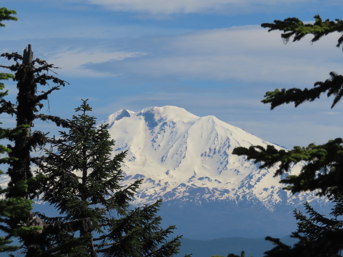
Looking down at the pullout from the PCT on the way back.

Be aware that FR68 is rough with numerous good-sized potholes and one large, steep drop that would be difficult for low clearance vehicles.

From the pullout we crossed the road at a large sign for the Wind River Experimental Forest and headed uphill on the PCT.
IMG_7208

IMG_7211

The PCT gradually climbed through a nice forest where a good number of wildflowers were blooming. There were also some glimpses of Mt. Hood through the trees. At the 1.3-mile mark the views to the south opened up where a large landslide at some point in the distant past had removed much of the forested hillside.
IMG_7215

IMG_7216Phantom orchid

IMG_7219Spotted coralroot

IMG_7223Finetooth beardtongue

IMG_7226Mt. Hood through a window in the trees.

IMG_7230Finetooth beardtongue along the trail.

IMG_7231White spiraea

IMG_7233Bluehead gilia

IMG_7237Paintbrush

IMG_7239Some yellow balsamroot along the trail.

IMG_7250

IMG_7252Columbine

IMG_7254Inside-out flower

IMG_7260Queen’s cup

IMG_7261

IMG_7262Bunchberry

IMG_7270Vanilla leaf

IMG_7274Arnica

IMG_7275Approaching the landslide area.

IMG_7280

IMG_7277Starting at the green up to the left is Augspurger Mountain (post) and Dog Mountain (post) on the Washington side of the Columbia River Gorge. Mt. Defiance (post) is the high point on the Oregon side with Mt. Hood to the right. The three lower peaks to the right of Mt. Hood are Tomlike, Chinidere, and Indian Mountain (post).

IMG_7279Mt. Hood from the viewpoint.

IMG_7290Lomatium, bluehead gilia, and arrowleaf buckwheat in the bowl.

The trail continued along above the landslide before veering left to pass around a rise along the ridge.
IMG_7294

IMG_7298Honeysuckle

IMG_7304

On the far side of the rise a spur trail led right to a small wildflower meadow along the side of the landslide.
IMG_7308

IMG_7309

IMG_7313

IMG_7318Wild onion mixed in with bluehead gilia.

20240622_075219Bluehead gilia

IMG_7326Lupine

IMG_7322Catchfly

Beyond the viewpoint the trail dropped to a saddle then resumed its gradual climb following the forested ridge. Just before the 3-mile mark we passed the Cedar Creek Trail coming up from the right. Along the way we passed through a couple more small meadows with nice wildflowers.
IMG_7328Arnica and beargrass in the forest.

IMG_7329Nearing one of the little meadows.

IMG_7332

IMG_7336

IMG_7340Sub-alpine mariposa lilies

IMG_7341Bluehead gilia

IMG_7338Sub-alpine mariposa lilies

20240622_080109A closer look shows why these are also known as cat’s ear lilies.

IMG_7339Buckwheat

IMG_7344Onion

IMG_7352

IMG_7357Bastard toadflax behind a cat’s ear lily.

20240622_080550Rosy pussytoes

20240622_080609Yarrow

IMG_7367Looking back from the meadow.

IMG_7373

IMG_7374I believe these are some type of microseris.

IMG_7383

IMG_7385Boundary sign for the Wind River Experimental Forest.

IMG_7387Broadleaf arnica

IMG_7391Star-flowered false solomonseal

IMG_7392The Cedar Creek Trail coming up from the right.

IMG_7393

IMG_7394Anemones

A third of a mile beyond the Cedar Creek Trail junction the PCT passed by a rocky outcrop. On the far side we took a path to the left leading to the top of the outcrop which had a great view of Mt. Hood and more wildflowers.
IMG_7397

IMG_7401Wallflower

IMG_7405White groundsel

IMG_7409

IMG_7411Cliff beardtongue

IMG_7417Cliff beardtongue

20240622_085221Wild rose

20240622_085457Larkspur

IMG_7425Mt. Hood from the viewpoint.

20240622_085410Spotted coralroot

IMG_7430Oregon sunshine and wild onions

IMG_7441Chickweed

While we were taking a break at the viewpoint another pair of hikers arrived (the only others we would see all day). We left the viewpoint to them and continued on.
IMG_7444Arriving at another small clearing with flowers.

IMG_7445Phlox, penstemon, lomatium, onion, and mariposa lilies.

IMG_7451

IMG_7459Another little meadow.

IMG_7455Larkspur and balsamroot

IMG_7462This was the only time we spotted Mt. St. Helens on the hike.

At the 4-mile mark (0.7 from the rock outcrop viewpoint) we arrived at the junction with the Grassy Knoll Trail.
IMG_7466

Almost immediately after passing this trail the Big Huckleberry Mountain Trail led uphill to the right.
IMG_7467

IMG_7468

We had forgotten how steep the 0.2-mile trail to the former lookout site was compared to the PCT, but the wildflowers and views from the long summit were worth it.
IMG_7469

IMG_7470

IMG_7476

IMG_7472Mt. Adams from the former lookout site.

IMG_7479There was a lot of phlox in bloom.

IMG_7478Table Mountain (post) and Greenleaf Peak (post)

IMG_7480Mt. Hood

IMG_7482Mt. Hood with Mt. Jefferson behind to the right.

We walked west from the summit down the wildflower covered ridge to get some additional views.
IMG_7488

IMG_7489Balsamroot and groundsel

IMG_7492Mt. Adams

IMG_7495Phlox

IMG_7496

IMG_7498Paintbrush and cliff beardtongue

IMG_7506Another view of Mt. Hood.

IMG_7510

IMG_7513

IMG_7515Sandwort

IMG_7512Chickweed

20240622_095908Balsamroot

IMG_7518Some of the smaller flowers present on the summit.

IMG_7520Finetooth beardtongue

IMG_7522Wallflower

IMG_7525Wild onion

IMG_7524The end of the ridge is about three quarters of a mile from the lookout site.

We took a break on a small rock outcrop to enjoy the scenery and the gentle breeze that was keeping things from being too warm.
IMG_7511Heather on the outcrop.

IMG_7530Painted lady

When we finally started back we heard voices which turned out to be the two hikers that we’d seen at the lower viewpoint. They had set up their amateur radio and had just been communicating with someone in Pennsylvania. We passed by and made our way back past the lookout site and down to the PCT.
IMG_7535

20240622_101609Larkspur
IMG_7546Swallowtail

IMG_7536Chickweed in some phlox.

We returned the way we’d come on the PCT enjoying the wildflowers the second time as much as we had the first.
IMG_7555

IMG_7562

20240622_105129Wallflower

20240622_105731Colubmine

IMG_7587Bluehead gilia

IMG_7596Beargrass along the PCT.

IMG_7607

IMG_7608Heading down to the trailhead.

The hike ended up being 9.3 miles with approximately 1460′ of elevation gain.
Screenshot 2024-06-23 052443

This was a great hike with good views, lots of wildflowers, and plenty of solitude. The only downside at all was the rough drive up FR 68. Happy Trails!

Flickr: Big Huckleberry Mountain

Categories
High Cascades Hiking Oregon Sky Lakes/Mountain Lakes Area Trip report

Seven Lakes Basin Backpack – 09/09/23 & 09/10/2023

As we near our goal of finishing at least part of all 100 featured hikes in William L. Sullivans “100 Hikes/Travel Guide Southern Oregon & Northern California” edition 4.2 (post) there was one backpacking trip left. Sullivan’s Seven Lakes West and Seven Lakes East (hikes 38 & 39 in edition 4.2) start at trailheads on opposite side of the Cascade Crest but both contain a loop through the Seven Lakes Basin and a climb up Devil’s Peak in the Sky Lakes Wilderness. Aside from the different trailheads the only other difference is that he includes a visit to Lake Alta from the west trailhead.

We opted to begin from the eastern trailhead – Sevenmile Marsh. The primary reason for this was the trailhead is roughly half an hour closer to Salem but the Forest Service currently shows the status of the western trailhead (Seven Lakes) as unreachable. (This may simply be an oversight when updating their webpages, but it is a good reminder that it’s always a good idea to double check with the managing agencies before heading out.)
IMG_8838Sevenmile Marsh Trailhead

The trail descended to a crossing of Sevenmile Creek then climbed gradually along a hillside above Sevenmile Marsh, entering the Sky Lakes Wilderness along the way.
IMG_8843

IMG_8844Sevenmile Creek

IMG_8847Entering the wilderness

IMG_8849Sevenmile Marsh

The Sevenmile Trail climbed gradually through a nice forest for nearly two miles before joining the Pacific Crest Trail.
IMG_8853Lodgepole pines were the dominate trees along the first part of the trail.

IMG_8859Mountain hemlock took over as the trail gained elevation.

IMG_8860

IMG_8861Junction with the PCT.

We turned left onto the PCT and found ourselves losing a bit of elevation before beginning another gradual climb.
IMG_8864

IMG_8867There were a few downed trees along this section but nothing difficult to get around.

IMG_8874This twisted tree caught our attention.

IMG_8877Nice blue sky.

IMG_8878Lewis’s woodpecker way up in a snag.

After two miles on the PCT we arrived at Honeymoon Creek which resembled a small pond. Tadpoles splashed around in the mud while larger frogs hung out around the water.
IMG_8881

IMG_8883Tadpoles

IMG_8885Frog in the water.

IMG_8888

After another 0.6-miles on the PCT we arrived at a signed junction with the Seven Lakes Trail.
IMG_8893Trail sign ahead on the right.

Our plan was to set up camp at Cliff Lake then do the loop and summit Devil’s Peak as described by Sullivan. We could have turned right here and followed the Seven Lakes Trail 1.3-miles past Grass and Middle Lakes to Cliff Lake, but sticking to the PCT for another 0.7-miles then turning the Cliff Lake Trail would save us nearly a quarter of a mile. We decided to save Middle and Grass Lakes for our hike out the following morning and stayed straight on the PCT.
IMG_8898

IMG_8909Unnamed creek along the PCT. We were surprised at how many of the seasonal creeks still had flowing water.

IMG_8911Grass-of-parnassus

IMG_8914Huckleberries, there were a lot of these around the basin which we happily sampled.

IMG_8917Devil’s Peak poking up above the trees.

IMG_8920The Cliff Lake Trail.

We turned right onto the Cliff Lake Trail and descended a third of a mile to rejoin the Seven Lakes Trail a tenth of a mile from Cliff Lake.
IMG_8922

IMG_8923Prince’s pine

IMG_8926Another flowing seasonal creek.

IMG_8930Crater Lake collomia (Collomia mazama)

IMG_8936The Seven Lakes Trail arriving on the right.
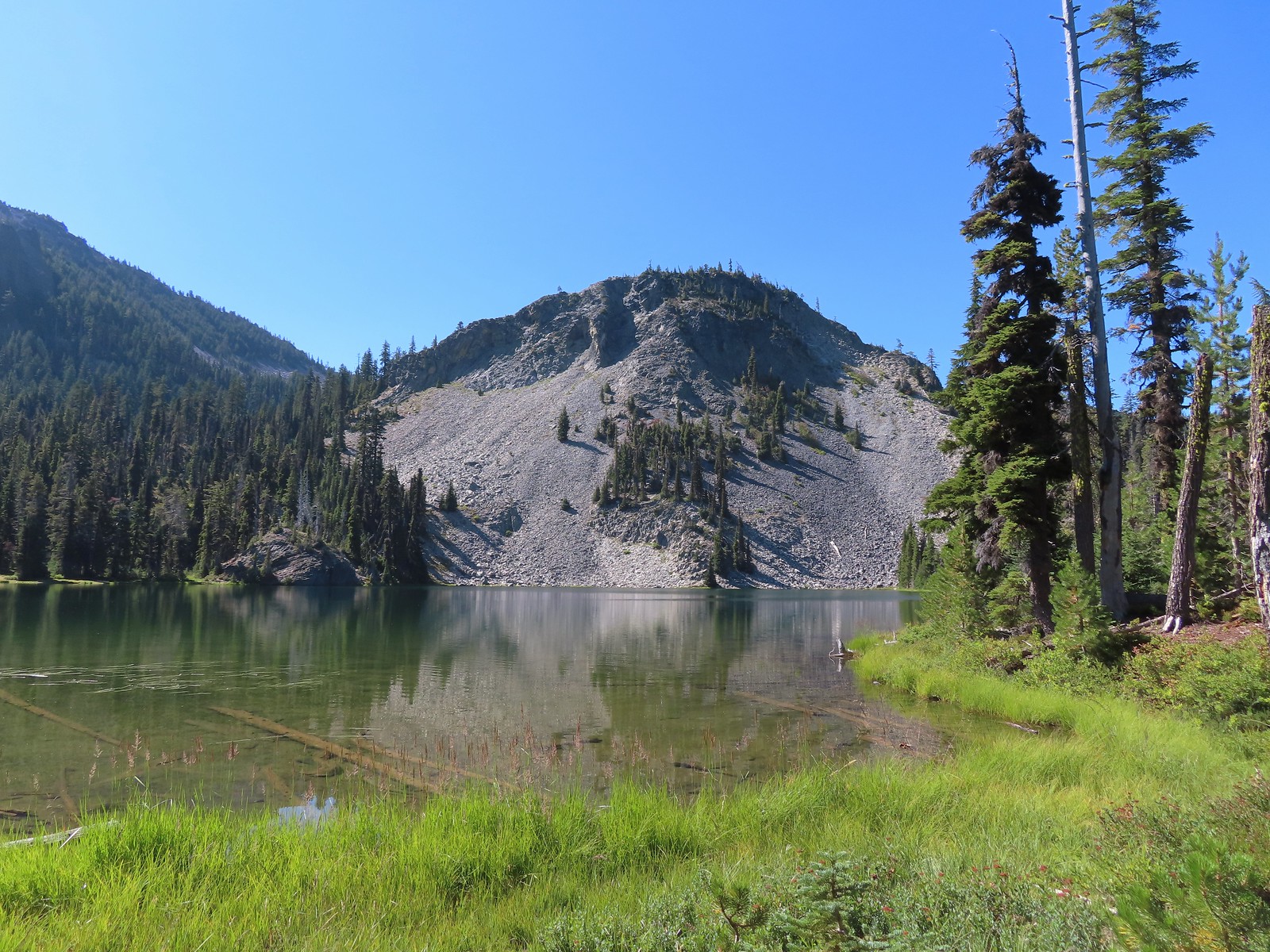
IMG_8939Cliff Lake

At Cliff Lake we turned onto a use trail following it around the eastern side of the lake in search of a suitable campsite. While there were numerous sites most of the sites we were seeing were large enough for multiple tents. We didn’t want to take up one of the large sites with our single tent and we also didn’t want to wind up with neighbors if we could avoid it. We wound up getting separated in the process and after walking back and forth for a bit we found each other and settled on a campsite.
IMG_8944

IMG_8943Arnica

IMG_8946Aster

IMG_8947

IMG_8951Splash in Cliff Lake from one of many fish that were feeding on insects.

IMG_8953Camp

After getting set up we grabbed our daypacks and headed back to the Seven Lakes Trail. We decided to hike the loop clockwise which meant backtracking along the Seven Lakes and Cliff Lake Trails to the PCT and then turning right to continue southward.
IMG_8965Huckleberry bushes along the Cliff Lake Trail.

IMG_8967Anywhere there was water nearby there were lots of tiny Cascade toads to watch out for.

IMG_8969Back at the PCT.

IMG_8970

IMG_8973Larger frog

IMG_8982Monkshood

IMG_8985More grass-of-parnassus

IMG_8986Not only were the toads tiny, they also were well camouflaged.

The PCT climbed steadily providing the first glimpses of the peaks around Crater Lake.
IMG_8988Mount Scott (post) between the trees.

IMG_8990Mount Scott

IMG_8993The Watchman (post) and Hillman Peak (post)

IMG_8995The Watchman and Hillman Peak

IMG_9001Devil’s Peak

IMG_9010Union Peak (post) in the distance.

IMG_9014Cliff Lake with Violet Hill beyond.

IMG_9021Black backed woodpecker

IMG_9042Getting closer to Devil’s Peak.

IMG_9048A much bigger Cascade toad.

Near Devil’s Peak the PCT left the trees and switchbacked up a talus field resulting on great view to the north toward Crater Lake and beyond.
IMG_9052

IMG_9053

IMG_9056

IMG_9055Mt. Thielsen (post) in the center beyond the rim of Crater Lake.

IMG_9057Union Peak with Mt. Bailey (post) behind to the right.

IMG_9059Lots of neat rock formation on Devil’s Peak.

IMG_9062Western pasque flower seed heads.

IMG_9063

IMG_9069Buckwheat

Two and a half miles from the Seven Lakes Trail junction the PCT arrived at a pass. The final climb was fairly steep even with switchbacks, so a brief rest was in order at the pass.
IMG_9070

IMG_9071Views to the South opened up at the pass including Klamath Lake and Pelican Butte.

IMG_9076Klamath Lake

IMG_9084Devil’s Peak and the PCT coming up to the pass from the North.

IMG_9078Klamath Lake, Pelican Butte, Aspen Butte (post) over the right shoulder of Pelican, Brown Mountain (post) is the small cone on the right, and Mt. McLoughlin (post)

IMG_9079Mt. McLoughlin

IMG_9081A faint Mt. Shasta which, given the wildfires burning in NW California was a bit of a surprise to be able to see.

IMG_9085The view North.

IMG_9086Goose Egg and Ethel Mountain in the forefront with Llao Rock, Mt. Thielsen, and Garfield Peak (post) behind.

IMG_9090Devil’s Peak

While we were resting at the pass we heard a helicopter approaching from the NW. It wound up hovering low above the lakes basin before heading back the way it came.
IMG_9092We were a little concerned at first that it might be picking up water for a new fire but there wasn’t anything hanging from the helicopter so we have no idea what it was actually doing.

A path headed uphill from the pass toward Devil’s Peak while the PCT headed slightly downhill.
IMG_9080The use path to Devil’s Peak on the right and the PCT on the left.

We headed up the use trail which was fairly easy to follow with just one slightly sketchy narrow spot.
IMG_9099

IMG_9101The rather ominously named Lucifer from the use trail.

IMG_9104A second use trail coming up from the opposite side.

IMG_9105Western pasque flowers on the hillside above the use trails.

IMG_9107The summit of Devil’s Peak ahead.

The views were excellent from the summit so we took another nice break to soak them in before heading down.
IMG_9110Looking North toward Crater Lake and Mt. Thielsen

IMG_9111Lucifer, Jupiter, and Venus

IMG_9112Lee Peak above the pass.

IMG_9114Luther Mountain (post) in the foreground with Aspen Butte, Brown Mountain and Mt. McLoughlin.

IMG_9115Remains of a former lookout.

IMG_9116The PCT below Devil’s and Lee Peaks.

IMG_9127

IMG_9119Goose Egg, Llao Rock, and Mt. Thielsen

IMG_9120Mt. Scott

IMG_9130Mt. Shasta to South through a little smoke but again we felt fortunate to be able to see the mountain at all.

IMG_9125Colorful grasshopper at the summit.

American pipitAmerican pipit

We headed down taking the other use trail which angled down along a ridge to the PCT approximately a third of a mile from where we had left it to climb Devil’s Peak.
IMG_9136The Seven Lakes Basin from the use trail down.

IMG_9138South, Middle, North, and Grass Lakes

IMG_9151Heading down the use trail.

IMG_9153Looking back up the use trail.

When we reached the PCT we turned right and headed toward Lucifer.
IMG_9154

IMG_9162Western snakeroot along the PCT.

IMG_9157A comma butterfly on western snakeroot.

IMG_9160Painted lady

At a ridge below Lucifer we arrived at a signed trail junction.
IMG_9168

Here the PCT forked left toward Luther Mountain while the Devil’s Peak Trail forked right. We took the Devil’s Peak Trail and followed it 1.3-miles to the Seven Lakes Trail. Passing below Jupiter and Venus along the way.
IMG_9171Venus from the Devil’s Peak Trail.

IMG_9176Looking back at Devil’s Peak.

IMG_9179Looking North across the Seven Lakes Basin.

IMG_9181Lake Alta in a bowl below Violet Hill.

IMG_9185

IMG_9187Pond along the Devil’s Peak Trail.

IMG_9193Coming up to the Seven Lakes Trail junction. A rock cairn was the only marker.

We turned right onto the Seven Lakes Trail and descended 0.2 miles to a signed junction with the Alta Lake Trail.
IMG_9195

IMG_9196

We turned left onto the Alta Lake Trail. We followed this trail for a fairly level half mile to the long lake.
IMG_9201

IMG_9213

Heather took another break at the South end of the lake while I hiked another quarter mile along the lake to get a better look at the northern end.
IMG_9215I was still only about halfway along the lake after the quarter mile. There used to be a campground at the North end.

IMG_9217Common merganser

IMG_9216The southern end of Lake Alta.

On the way back to Heather I detoured to take in the view from the cliffs above the basin.
IMG_9221Cliff Lake below Devil’s Peak and Middle Lake.

IMG_9222Middle and Grass Lakes

IMG_9224I could hear several pikas in the rocks below the cliffs but the only thing I spotted was a chipmunk.

IMG_9223Chipmunk

After rejoining Heather we headed back to the Seven Lakes Trail and continued descending into the basin.
IMG_9230Sulphur butterfly on aster.

IMG_9237

20230909_171011Gentian

IMG_9245Fireweed

A mile from the Alta Lake Trail we arrived at South Lake.
IMG_9252

IMG_9256South Lake

Another quarter mile brought us to a view of Cliff Lake.
IMG_9259

IMG_9261Devil’s Peak from the trail. There were more pikas “meeping” from the rocks here but again we failed to spot any of them.

We followed the trail around to the North side of Cliff Lake and then turned on the use trail to return to our campsite.
IMG_9262

IMG_9266

Back at camp we refilled our water supply and had dinner then relaxed a bit before turning in for the night. For me this had been a 15.3-mile hike with 2000′ of elevation gain. One and a quarter of those miles was hiking from the Seven Lakes Trail to our camp, and initially wandering around looking for a site and Heather.
IMG_9280Devil’s Peak in the evening.

IMG_9282So many fish in the evening.

In the morning we packed up and headed back, this time sticking to the Seven Lakes Trail to visit Middle and Grass Lakes.
IMG_9285

IMG_9291Devil’s Peak in the morning.

IMG_9297Seven Lakes and Cliff Lake Trail junction.

IMG_9304We reached Middle Lake in 0.4-miles.

IMG_9305

IMG_9311We detoured left at the northern end of the lake following a pointer for Lake Ivern to find a view back across Middle Lake.

IMG_9312Devil’s Peak from Middle Lake.

We returned to the Seven Lakes Trail and in another half mile we passed views of Grass Lake.
IMG_9319Stream crossing.

IMG_9325Monkshood and grass-of-parnassus

IMG_9333Grass Lake

We didn’t follow any of the use trails down to Grass Lake and instead stuck to the Seven Lakes Trail as it climbed for 0.2 miles to the Pacific Crest Trail.
IMG_9337

IMG_9341Arriving at the PCT.

We turned left onto the PCT and returned to the Sevenmile Marsh Trailhead the way we’d come the day before. Of note were the ducks making use of the small pond along Honeymoon Creek.
IMG_9344

IMG_9347

IMG_9349Golden-mantled ground squirrel

IMG_9353Sevenmile Trail at the PCT to return to the Sevenmile Marsh Trailhead.

IMG_9361Exiting the Sky Lakes Wilderness.

The hike out came to 6.1-miles with just 200′ of elevation gain.

The red section marks our track out past Middle and Grass Lakes

This was a great trip. The temperatures were pleasant, the views great, lots of huckleberries and only a few mosquitos. We also only saw a total of eight other people all weekend. We are now down to a half dozen featured hikes from the Southern Oregon/Northern California book and if conditions cooperate we may well be finished by November. Happy Trails!

Flickr: Seven Lakes Basin