
We had visited Neahkahnie Mountain in January 2014 (post) and had wanted to come back in Spring to hopefully see some wildflowers. The Oregon Coast Trail (OCT) crosses over Neahkahnie Mountain passing below a rocky viewpoint. In 2014 we had come from the north so this time the plan was to start from the south using a newer section of the OCT beginning in Manzanita, OR. Heather had other plans, so I was on my own for this outing, and decided that I would go up and over Neahkahnie Mountain and visit the Devil’s Cauldron before climbing back over to Manzanita.
The trailhead for the OCT is just a pullout on the shoulder of Neahlem Road.
 I had arrived just after 6:30am so it was still a little dark as I set off.
It was early enough that I didn’t have to worry much about traffic when I crossed Highway 101 from Nehalem Road to the signed Oregon Coast Trail.


This 2.1-mile section of the OCT was constructed in 2020 and passes through the Neahkahnie Headwaters Preserve managed by the Lower Nehalem Community Trust.
 Please respect private landowners wishes when recreating to ensure that public access continues to be allowed.
The trail began with a couple of ups and downs as it followed a powerline corridor.
 Looking back at the sunrise.
The trial eventually left the powerlines and passed through a few stands of trees before arriving at a clearcut. The trail continued climbing through the clearcut and then reentered the forest. Approximately two miles from the trailhead I arrived at a signboard along Road 38555 where I turned left, hiking downhill past a gate to the South Neahkahnie Mountain Trailhead.


 Entering the clearcut.
 Bleeding heart
 The OCT is well marked.
 Woodpecker
 Back in the forest.
 Interpretive signs in the preserve.
 Bench at a viewpoint.
 Nehalem Bay (post) from the bench.
 Salmonberry blossom
 Leaving the preserve.
 Violets and pink fawn lilies. These were the first pink fawn lilies I had seen, it seems that we hadn’t timed our coastal hikes right to catch their bloom in the past.


The trailhead was empty at 7:20am.
Trail signs identified the continuation of the OCT which began a series of approximately a dozen switchbacks through the forest.

 Trillium
 Fringecup

 Toothwort

The switchbacks led to a 4-way junction with an old roadbed where the OCT continued on the opposite side.

For the next half mile the trail traversed along the hillside below the summit ridge of Neahkahnie Mountain.

 I made use of this bench on the way back to take a break and do some stretching.
 View to the north.
 Tillamook Head (post) and Haystack Rock (post)
After the half mile the trail made a switchback. The trail here was a little sketchy.

 It was obvious that there had been some work done to try and shore up this section of trail.
The trail continued to a saddle where a spur to the right led up a rocky spine to the viewpoint summit.

 The view south from the viewpoint.
 Cape Meares (post), Three Arch Rocks, and Cape Lookout (post).
 Cascade desert parsley near the summit.
After taking in the view I returned to the OCT and continued north.

 Looking up at the viewpoint from the OCT.
It was a little over 2-miles down to the North Neahkahnie Mountain Trailhead. A September 2020 windstorm had resulted in heavy blowdown to sections of this trail. The trail was closed until 2022 when crews were able to clear it.
 Trillium
 This was the only obstacle that required any sort of maneuvering.
 There are some great trees along the upper section of the trail.
 Violets
 Recent trail work.
 Anemones and violets.
 Entering the storm damaged area.
 Angora Peak (post) through the trees.
 Getting creative with the trail route.
 Out of the storm damage.
 Skunk cabbage
 Cape Falcon from the trail.
 Pink fawn lilies

 Arriving at Highway 101 near the North Neahkahnie Mountain Trailhead.
I dashed across the highway to the trailhead and immediately spotted a few elk in the meadow below the highway.


From the trailhead I picked up the Elk Flats Trail and followed it a tenth of a mile to the Devil’s Cauldron Overlook Trail.


Another tenth of a mile brought me to the overlook.


After admiring Devil’s Cauldron I headed back. The climb back up to the saddle below the viewpoint was approximately 1400′, and after having climbed over 1600′ from Manzanita, and I felt the burn.

 Snow queen
 He may have been moving faster than I was.
 There is nothing better than hearing wrens sing in the forest.
 More creative trail in the storm damaged area.
 Wood sorrel
 The view if you don’t scramble up the spine.
Up to the point that I started back down from the saddle I’d passed 11 people on the trail, all of which were after having spent time at the viewpoint. On the way down I passed at least 30 people between the saddle and the South Neahkahnie Mountain Trailhead which was now packed with cars.

 Trillium with a touch of pink.
 Arriving at the packed trailhead.
Continuing on from the busy trailhead I only passed two more people before arriving back Nehalem Road and my lonely car.
 Leaving the crowds behind.
 Big patch of pink fawn lilies.

 Highway 101 from the powerline corridor.
 Margined white
 One of the more impressive trees in the preserve.
 Nearing the Highway 101 crossing. I arrived just as a long line of traffic was passing by but was able to safely cross shortly afterward.
This hike came in at 11.6 miles and roughly 3000′ of elevation gain.

This was a good hike with quite a few wildflowers, some wildlife, and some nice views. It was also a good training hike for some of the alpine hikes with significant elevation gain later in the season. The various trailheads offer plenty of options for those who might not want to hike as far or climb so much, but even the shortest route (South Neahkahnie Mountain Trailhead) gains 840′ in 1.5-miles to the viewpoint. Happy Trails!

 The small blue sign on the left provides the pay by phone information. This was one of two such signs in the parking area.

 Little Joe Creek
 The pointer to the right was for the Sandy and Salmon Rivers (.25 miles) while continuing another .18 miles would bring us to the Sandy Ridge Trail System.


 Start of the Falls Looop.
 Primitive Trail number 2 with the Falls Loop continuing to the left.

 This was a nice little cascade this time of year. Later in the Summer the flow reportedly drops down to a trickle.
 The self-guided nature tour follows the Northern Loop Trail here as well.
 Passing stop #6 on the self-guided tour (Forested Headwaters).
 One of the creeks flowing from the forested headwaters.


 There are a few Eagle Creeks in Oregon, this is the Eagle Creek that originates in the Salmon-Huckleberry Wilderness (


 Snow queen
 One of several switchbacks.
 Rough-skinned newt and snow queen.
 Closer look at the newt.
 Blue sky
 Traversing the hillside.
 The trail below as we neared a switchback to begin descending.


 Viewpoint near the end of the loop.
 The start of Loop D from Kitzmiller Road.
 The remains of former signs can be seen at the split ahead.
 The trail made a steady climb to the junction with the supposed Lollipop Loop.
 The lower portion of the tree across the switchback.
 Left is the continuation of Loop D. We stayed right to attempt the Lollipop Loop.
 There were some cut trees along the trail mixed with more recent blowdown but nothing was particularly difficult to navigate.
 Wren
Wren There was a lot of snow queen.
 The footbridge with a large tree across it.
 Look back along the bridge.
 The older blowdown had all be cut.
 I made it through this muddy mess but couldn’t find any sign of tread on the opposite side.


 Swagger Creek
 Song sparrow (according to Merlin)

 The second unsigned junction.


 Swagger Creek (right) joining Clear Creek at the suspension bridge.
 The Nature Trail wasn’t signed other than some “No Motor Vehicles” signs.
 The old roadbed.
 Relative locations of the three stops plus Milo McIver from our previous outing.


 McIver Memorial Viewpoint
 Clackamas River from the viewpoint.
 The small trail sign on the left is labeled “Viewpoint Trail”.
 Map on the signboard. Oddly the Viewpoint Trail is not shown on this map even though the trail continues past the signboard.
 The Vortex Meadow through the trees.


 Former model airplane landing strip in the meadow.

 There were some limited views of the Clackamas River from this trail.
 While we were happy to see trail signs again it was a little confusing to see the Riverbend Trail pointer here. Here again the maps that we had did not show this junction. They did show a 4-way junction between the Riverbend Trail and Vortex Loop but only after crossing a road which we had not done.


 Viewpoint near the group camp.

 Had we not backtracked through the group camp we would have connected with the Riverbend Trail after crossing a road then turned right on the Riverbend Trail, recrossed the road, and arrived at this junction on that trail which was now on our left.


 Stellar’s jay

 We stumbled on a one-leg standing competition that the local geese were engaged in.
 The mallards seemed unimpressed with the geese’s balancing abilities.
 Common mergansers


 Common merganser drake
 We found this nice little bridge wandering around the disc golf course attempting to connect with the Maple Ridge Trail.


 The Cedar Knoll Trail connects the upper and lower segments of the Maple Ridge Trail. We stayed right on the Maple Ridge Trail.
 Colorful fungi
 Wood ducks on Wood Duck Pond. It’s pretty rare that the animal a feature is named after is actually present.


 Not sure if this is just the biggest rough-skinned newt we’ve ever seen or a different type of salamander.
 Great blue heron by a small pond. It was probably hunting the frogs that were croaking loudly here.
 The sign ahead is for the Cedar Knoll Trail joining from the left.
 Dropping down to the Riverbend Loop Trail junction.
 The Maple Ridge Trail makes another nearly 180 degree turn here and drops down to the parking area a short distance from its other end.
 We stayed right here again at a junction with a trail leading to the Maple Ridge Picnic Shelter.
 I believe these are sweet coltsfoot starts.
 There was a bench next to this nice little creek.
 Nearing the Riverbend Day Use Area entrance road.


 Song sparrow

 It’s hard to make out but there is a coyote in this photo.
 I have no idea what’s going on with this photo of the coyote as it was trotting away from us. Shortly after this it popped out from behind some brush and jumped into the air to pounce on something. That was the last we saw of it.
 Squirrel
 Left to right: Silver Star Mountain, Little Baldy, and Bluff Mountain (
 Mt. Hood making a partial appearance.


 1930 Caterpillar Model 30
 Bridge over Cedar Creek.
 Cedar Creek
 North Scappoose Creek
 Sun hitting the top a hill in the distance.
 There was a lot of
  Forest along the trail.
 One of several interpretive signboards along this segment.
 While the Sun was out the trail remained mostly shaded and therefore cold. We both would have benefited from some slightly warmer layers.
 Hair ice
 More hair ice
 Another interpretive sign ahead.
 MP 13
MP 13 The Nehalem Divide TH on the left and the Crown Z Trail continuing on the right.
 I believe that is Silver Star Mountain (

 North Scappoose Creek winding past a private home.
 The Ruley Trailhead ahead.


 We started with this hike in part due to it being the first day of the final king tides, abnormally high tides, for the season. High tide for Smelt Sands was going to be 9:45am so we were hoping to see some of the wave action.
 It was just before 8am as we hiked the 804 Trail.
 We made a mistake and turned right on the paved path here, but we should have continued beyond the large signboard to a second path marked by a wooden post. You can see the small white and black to the left of the green signboard. We may have been distracted by “Free Coffee” being printed on the bottom of the green sign.
 This post is similar to the one along the 804 Trail where we should have turned right.


 Boardwalk over Mitchell Creek.
 Grandmother Spruce
 The upper end of the preserve trail.

 Mushrooms
 Approaching Starr Creek.
 Starr Creek
 The upper gate at the junction.
 Ya’Xaik Trail
 The right hand fork here is the trail leading down to the fire station that dog owners can use to make a loop. A local had warned us that this trail can be pretty slick. We went left to remain on the Ya’Xaik Trail.
 There was a little climbing involved before the trail headed down to Diversity Drive.


 The Ya’Xaik Trail at Diversity Drive.


 The Woodland Trail continues to the left while the right connects up to a road.


 A footbridge over the Red River below with a disc golf hole on the opposite ridge. We were able to use the OregonHikers Field Guide map to identify this connector trail as one we did not want to take. That map had many of the connector trails identified in red which helped keep our position located as well as keep us on the correct route.


 The old roadbed at the bottom of the switchbacks.
 Woodland Trail on the left and our next stop, the Lint Slough Trail, on the right.


 Memorial plaque
 There was a bypass uphill for this short flooded section.
 There were a number of bufflehead ducks, a pair of geese, and one noisy great blue heron at the slough. All of the wildlife seemed to be positioned as far away from the trail as possible.
 The great blue heron in a tree across the slough.
 This little group of buffleheads was the exception.
 I turned around at this bench due to not seeing an obvious continuation of the trail here. I had also lost Heather who had stayed up to avoid the flooded section and instead of returning to the trail I was on, on the other side of the flooded bench, stayed up on the higher path. That path began leading up uphill away from the actual trail without another way to get back to the correct path. She wound up backtracking and we met shortly after I had started back.
 The slough from my turn around point.
 Yarrow
 Bull thistle (non-native)
 Rose (probably non-native)


 Looking north along the beach.
 The view south.
 The wet sand and debris from the high tide was up to the vegetation along much of the beach.
 We decided to turn back at the creek partly to avoid crossing it, but also because we had been walking into the wind. It wasn’t a particularly cold day, but the wind chill was almost making it uncomfortable.
 Seagull with a crab.
 Cape Perpetua (
 Buckley Creek
 We had to ford Buckley Creek which was only a couple of inches deep at most.
 Semipalmated plovers
 Western gull
 Heading back north.
 The path back up to the parking area at Driftwood Beach.


 The trailhead.
 The caution sign was related to some pile burning that the Forest Service had been doing.
 McKenzie River

 Mushrooms
 National Recreation Trail symbol on a tree to the left.


 Private Road sign on Duffy Rd.
 There was quite a bit of witches’ butter fungus along the trail.
 There were a lot of other mushrooms too.
 Unnamed creek crossing.


 Ruby-crowned kinglet. We didn’t see much wildlife on this hike but there were several kinglets flitting among the trees here. This was the only photo of one I managed to get though.
 We had not expected any blue sky so this was a treat. It had rained for most of the drive and sprinkled for a minute shortly after we started hiking, but it had been dry otherwise.
 The trail switching back up a small hill.
 The most significant elevation change was this decent to a footbridge over Lost Creek.
 Coral fungus
 Lost Creek
 The footbridge over Lost Creek was a little over 4.5-miles from the Lower McKenzie Trailhead.
 Lost Creek
 Willamette National Forest Boundary
 Approximately 5.25-miles from the trailhead we crossed Belknap Hot Springs Road.
 Sign for the
 Unnamed seasonal stream.
 Footbridge over Scott Creek.
 Scott Creek
 Mushrooms
 Footbridge over Boulder Creek.
 Highway 126 bridge over Boulder Creek from the footbridge.
 Boulder Creek flowing into the McKenzie River.
 Forest Road 2650.
 Boat ramp at Forest Road 2650.
 The river from Forest Road 2650.

 This short section along the road is just east of Belknap Springs Road.
 Madrones
 A little sunlight on the forest floor.
 Rain shower falling over Lost Creek. It wasn’t raining hard enough to convince me to pull my rain gear back out.
 I spotted Heather with a little over three and a quarter mile left back to the trailhead. (Look for a little orange in the trees ahead and to the right of the trail.)


 Ours was the only car at the trailhead when we got back.
 Red – Clear Lake, June 2014 (


 The North Rim Trail heads left at a fork with the Twin Falls Trail a short distance from the parking lot.
 I stuck to the North Rim Trail here leaving another (short) trail to do next time.
 The Nature Play Area along the loop trail I didn’t take.
 One of two bridges along the North Rim Trail.
 Railing near the North Falls Viewpoint.
 North Falls from the viewpoint.
 North Falls
 Map located at the North Falls Trailhead.
 Upper North Falls from the Upper North Falls Trail.
 Upper North Falls.
 The split in the Trail of Ten Falls where the Canyon Trail heads down to North Falls.
 North Falls
 Trail behind North Falls.
 Behind North Falls.
 I will always take pictures of these large boulders in the creek.
 Trail marker at the Twin Falls Trail junction.
 Twin Falls
 Twin Falls is a tough one to get a good clear view of the full waterfall. Recent rainfall had provided good flow for this fall which helps with the visibility.
 This is Twin Falls on July 7, 2006.
 All the rain had the side creeks and falls flowing as well.
 Nearing the Winter Falls Trail and its bridge over the creek.
 The view from the bridge.
 Winter Falls from the Winter Falls Trail.
 Winter Falls

 The forecast had called for sunny skies, but we were also dealing with an air stagnation warning. For a brief moment I thought the fog might burn off, but that never materialized and by the time I arrived at South Falls more fog had rolled in.
 There are some nice big trees scattered throughout the park.


 Trail of Ten Falls/Canyon Trail above South Falls.
 South Falls
 Behind South Falls
 For a short loop just to South Falls you can cross the bridge and return to the rim.

 The trail below heading for Lower South Falls.
 From behind Lower South Falls. I scared a poor woman so badly as I neared the falls. She was setting her phone up on a tripod for a selfie and didn’t see me coming nor could she hear me with the roar of the falls until I was just a couple of feet away. When I said that I was just going to sneak behind her she let out the loudest scream I’ve heard in a while.
 Ankle deep pools behind the falls.
 Lower South Falls
 The mile long Maple Trail (right) allows for a shorter loop to both the falls on South Fork Silver Creek.
 This is now the North Fork Silver Creek.
 Unnamed falls on a side creek.
 The footbridge over the North Fork Silver Creek.
 Pool below the bridge.
 Lower North Falls
 Footbridge over Hult Creek and the spur trail to Double Falls.
 Double Falls
 Back on the Canyon Trail.
 More fog.
 Drake Falls
 Middle North Falls
 Spur trail (right) to Middle North Falls.
 Behind Middle North Falls.
 Splash pool
 The Winter Falls Trail footbridge spanning the creek ahead on the right.
 Chipmunk.
 Twin Falls again which meant I was nearly to the Twin Falls Trail.
 Twin Falls Trail junction.

 The Twin Falls Trail leveled out near its end.
 Arriving back at the junction with the North Rim Trail.
 I spotted several ruffed grouse as I was driving out of the trailhead.
 Hunting information kiosk across from the Turtle Flats parking area.
 The Turtle Flats restrooms. (Photo from the afternoon.)
 The entire Turtle Flats Trail in one photo.
 Viewpoint at the end of the trail.


 I turned right here following said map through a small section of trees.
 Poison oak is hard to miss when it is sporting its Fall colors.
 Emerging from the trees and staying right.

 McCulloch Peak (
 Mary’s Peak (
 One of several raptors hunting over the fields.
 Pigeon Butte to the left and Green Peak in the distance.

 Fog and McFadden Marsh to the left.
 Mallards
 Geese flying overhead.
 Egret and ducks
 Egrets
 More egrets
 Heron with the egrets.
 McFadden Marsh
 Egrets and a murder of crows.
 Great blue heron
 Red-winged blackbird
 Prairie Trail along McFadden Marsh.
 I could just make out the railings along Bruce Road from here.
 Nutria family near Bruce Road.
 The nutria family.
 The Prairie Trail at Bruce Road.
 Northern flicker
 Starling
 Muddy Creek
 Interpretive signs at the larger parking area.

 California scrub-jay
 Peregrine falcon?
 Pigeon Butte across Cheadle Marsh.
 While I was photographing this egret I glanced to my left and noticed a buck staring back at me.
 Meanwhile a great blue heron decided it wanted the egret’s perch.
 The heron and egret
 American coot
 The roof of the Cheadle Barn poking up from the hill.
 California quail escaping into the blackberry bushes.
 The small hill up to the junction below the barn. My legs let me know that even this small hill was more than they were interested in today.
 Robin
Robin Spur trail to the Cheadle Barn.
 Spotted towhee
 The pond and Cheadle Barn.
 Ducks in the pond.
 Pied-billed grebe. I also had a yellow-rumped warbler nearly land on me, but then it disappeared into the trees across the pond.
 The gravel road that serves as the Pigeon Butte Trail ahead.
 A successful egret and unfortunate rodent.
 The junction is located at the crest of the trail/road.
 Spur trail to the summit of Pigeon Butte.

 The dry ponds hosted a good number of songbirds.
 It appeared that there had been a number of controlled burns performed throughout the refuge.
 The 0.9-mile section ended at a junction with the Cattail Pond Trail.
 Viewpoint bench looking toward Cabell Marsh.
 Woolly bear caterpillar sharing the trail.
 Gray Creek
 Mallards
 More mallards
 Maple Knoll on the far side of Cattail Pond.
 I’m assuming nutria but am not 100% convinced on this one.
 This section was a mixture of the edge of fields and wooded trail.
 Follow the pointer.
 A cedar waxing joined by a pair of finches.

 I turned right at this sign onto the Beaver Pond Trail and followed it a half mile back to the gravel roadbed.
 Just under 100 yards from the Cattail Pond Trail is this unsigned junction. The left is a half mile out-and-back spur on along the side of Maple Knoll. I stayed right this time having done the spur in 2020 with Heather.
 The trail passes the Beaver Pond just before arriving at the roadbed.
 The Beaver Pond was pretty well deserted given its lack of water.
 I turned left onto the Mid-Refuge Connecting Trail.
 Authorized personnel only on the right-hand fork here.
 Arriving at the junction.
 The right fork is the trail I came up. The center fork is the Mill Hill Trail, and the left fork is the Mill Hill Loop Trail which loops around Mill Hill in 1.7-miles and arrives back at the junction where I took this photo from.
 There are several junctions along this stretch, most of which are well signed.
 This junction marks the start of the Intertie Trail.
 Crossing Finley Refuge Road.


 Signage at the Woodpecker Hill Loop.
 The Woodpecker Hill Loop is a well-developed interpretive trail.
 Stellar’s jay
 Each of these kiosks has an informational placard inside.
 Near the crest of the trail.
 The shelter on Woodpecker Hill.
 Dragon fly
 Signboard at the Woodpecker Hill Trailhead.
 Yay, more uphill.
 The back of a killdeer.
 Bald Hill on the left.
 Winkle Butte is the near rise on the left. On a clearer day Mt. Jefferson would be visible in the distance to the right of Winkle Butte.
 Cabell Barn ahead.
 Historic granary
 The lodge in April, 2021.


 Geese
Geese Pigeon Butte from the marsh.
 Great blue heron towering over the ducks.
 An egret along the shore to the right.
 The egret facing off with the heron. The mallard appeared to be ready to act as the referee.
 After a brief face off the egret moved on.
 Observation blind accessed via the Homer Campbell Boardwalk.

 Signboard at the boardwalk trailhead.
 Back on the refuge road.
 Muddy Creek
 The path to Turtle Flats on the left and the start of the Prairie Trail ahead on the right.

 This trail would eventually end at the LoneWolf/Patterson Mountain Trail (
 The small trailhead along Highway 58.
 Wrong way dummy.
 The South Willamette Trail to the right.

 It was clear that mountain bikers use this trail regularly.


 I actually waited until I was on my way down to step off trail and look at the arch.
 Eula Ridge Trail sign at the Hardesty Trail junction.
 The lefthand fork leads to the viewless summit while the right is the Hardesty Cutoff Trail which bypasses the summit.
 Forest below the Hardesty Cutoff Trail.
 The Sawtooth Trail dropping to the right.
 I was not looking forward to climbing back up some of these sections later.
 Another saddle.
 A view through the trees.
 I passed the Hardesty Way Trail 1.5-miles from the Hardesty Cutoff Trail.
 Mount June from the hillside.
 Wallflower
 Junction with the Lost Creek Trail.
 The pointer for Eagles Rest (
 I called this section “rhododendron ridge”.
 The Mt. June Trail coming up from the right.


 If you look closely, you can see the tops of the Three Sisters poking up over the smoke in the distance. The open hillside in the foreground is the meadow below Sawtooth Rock and the hump just behind is Hardesty Mountain.
 Heading down from the summit.
 Climbing the hillside below Sawtooth Rock.
 Sawtooth Rock
 There was just a little smoke now and then in the forest.
 The Eula Ridge Trail coming into view.
 There wasn’t much in the way of Fall colors along the trail, but these leaves really stood out.
 Lookout Point Lake (Middle Fork Willamette River) from the trail.
 There was one more small uphill on the far side of South Creek before dropping to the trailhead.
 South Creek

 Not having light until after 7am is rough for someone who likes to get an early start.
 The Salmon River Trail is located next to this interpretive sign near the trailhead.
 A flash was necessary as I set off.
 There was a very brief road walk along this section.
 There was also plenty of time along the Salmon River.
 I veered right at this picnic table to cross into the campground.
 The day use area at the campground.
 Water spigot at the day use area.
 It was hard to read the date for this cougar sighting, it appeared to be from June, but I couldn’t make out the year.
 Entering the Salmon-Huckleberry Wilderness
 One of the downed trees, this one covered both sides of a switchback.
 A rare viewpoint along the forested trail.
 A level stretch along a narrow ridge.
 A healthy looking paintbrush.
 The Sun rising above Hunchback Ridge.
 It was going to a be a bluebird day.
 Sign ahead marking the Hunchback Trail junction.

 One of the “downs”.
 This trail was also in good shape with just a few easy obstacles.
 I did not go investigate the source of the “water”, it could have been a trap (there is a spring shown on the map).
 Signs at the junction below Devil’s Peak.
 Mount Jefferson
 Olallie Butte (
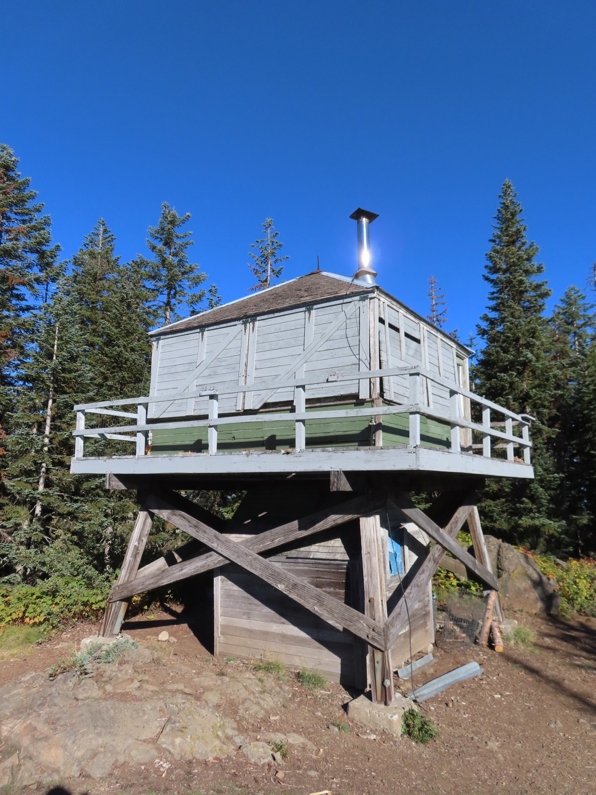
 The lookout from the Mt. Jefferson viewpoint.
 Mt. Hood from the lookout.
 You can’t see Mt. Jefferson from the lookout due to trees.
 Trail signs at the Cool Creek Trail junction.
 Lookout Mountain(
 Mt. Hood from the Hunchback Trail.
 Arriving at the trailhead on FR 2613.
 It’s hard to make out in the photo but that is a giant pothole (crater) in the middle of the road seen from the trailhead.
 That is the trailhead at the end of the road on the right.


 There were some nice Fall colors along the Kinzel Lake Trail.
 There were also a few obstacles that were trickier than anything on the other trails involved in this loop.
 Salmon Butte (
 Nearing the Salmon River Trail.
 Trail sign at the Salmon River Trail junction.

 There wasn’t much water at all in any of the side creeks.
 There are several viewpoints just over 3.5-miles from the trailhead.
 The furtherst hump in the center is Huckleberry Mountain (
 Wilderness kiosk along the trail. There were self-issued permits here, but none at Green Canyon Way so I stopped and filled one out even though I was almost done with my hike (and out of the wilderness).

 Salmon River
 There were a couple of good-sized fish in the pool here.
 The trail arriving back at the trailhead.
