Despite hiking regularly for a dozen years there are still plenty of places and trails close enough for a day trip that we’ve yet to make it to. We’ve made it a priority for our outings to involve such places when possible and was the purpose of our most recent outing. Matt Reeder’s “Off the Beaten Trail” (2nd edition) includes an entry for Black Wolf Meadows and High Rock (hike #39), a pair of short hikes in the Clackamas Foothills off of Forest Road 58. Combined, these hikes total right around 4-miles which prompted us to look for another stop we could add and landed on Pyramid Lake which I found using the Oregonhikers.org Field Guide.
We decided to start with the hike to Pyramid Lake and parked along FR 140 whish was the suggested trailhead in the Field Guide entry. This road is narrow and overgrown so expect to pick up some scratches from brush if you decide to drive it.
 We parked on the shoulder here and road walked three quarters of a mile to the official trailhead.
 This is a good example of why we parked where we did.
 The official trailhead.
It’s just 0.2-miles to the lake from this trailhead, but the initial climb is pretty steep. The lake is located within the Roaring River Wilderness. This would be just our second time hiking in that wilderness area joining our 2013 Shellrock & Rock Lakes hike (post).


 A pair of Barrow’s goldeneye ducks enjoying a morning swim on the far side of the lake.
We attempted to follow a use trail around the lake, but it quickly petered out in the brush so we called it good and headed back to our car.
 The use trail
 Mushroom along the road walk back to the car.
This stop came in at 2.6-miles with a little over 300′ of elevation gain, primarily in the initial steep climb from the official trailhead. After returning to FR 58, where we turned left, we continued 1.2-miles to a sign for Anvil Lake. We turned right onto spur road 5800-160 and followed this narrow gravel road 0.4-miles to a pullout on the left at a closed road just beyond the signed Anvil Lake Trail.
 The somewhat obscured sign for the Anvil Lake Trail along spur road 5800-160.
 The pullout where we parked.
The Anvil Lake Trail was historically part of a Native American route from the Cascade crest to the Estacada area. The trail is fairly level to start and reaches Black Wolf Meadows near the half mile mark.


Old growth cedar along the trail.
There was a variety of large mushrooms on the forest floor along the trail.


There was also a bit of blowdown to climb over.
 The edge of Black Wolf Meadows.
 Sign in Black Wolf Meadows.

Earlier in the year the meadows are rather wet, but today the only moisture was from the morning dew.


Explorers gentian. There were many of these gentians in the meadows, but they all appeared to have finished blooming weeks before.
 The trail leaving the meadows.
Soon after leaving the meadows the trail began a gradual descent before reaching a signed junction with a short spur trail to Anvil Lake.

 More mushrooms
 Rough-skinned newt


 Old sign near Anvil Creek.
 The dry bed of Anvil Creek.
 Coral fungus
 The sign for the spur trail ahead on the left.
 Pointer for Anvil Lake. According to the Oregon Hikers Field Guide this sign is likely over 50 years old based on the reference to S-502 which is currently known as FR 5820 which is another potential trailhead for this hike.
We turned down the spur trail which dropped somewhat steeply before arriving at the lake in just over 100 yards.

 Anvil Lake

Wood duck house reflecting in the lake.
There is just one small campsite at the lake. We’d seen a gentleman heading toward FR 5820 just as the junction with the spur trail had come into view, but there was no one at the lake now. After a brief break we headed back. It was interesting to find that in the short amount of time that had passed since our first trip through Black Wolf Meadows nearly all of the dew was now gone.


This stop was just slightly longer than the hike at Pyramid Lake, coming in at 2.7-miles. The elevation gain was just 190′ and a lot more gradual than it had been at Pyramid Lake.
We hopped back in our car, returned to FR 58, and turned right to continue another 0.6-miles to a signed junction where we veered right following a pointer for High Rock. After another paved mile we turned into a large unsigned pullout for our final hike of the day to High Rock.

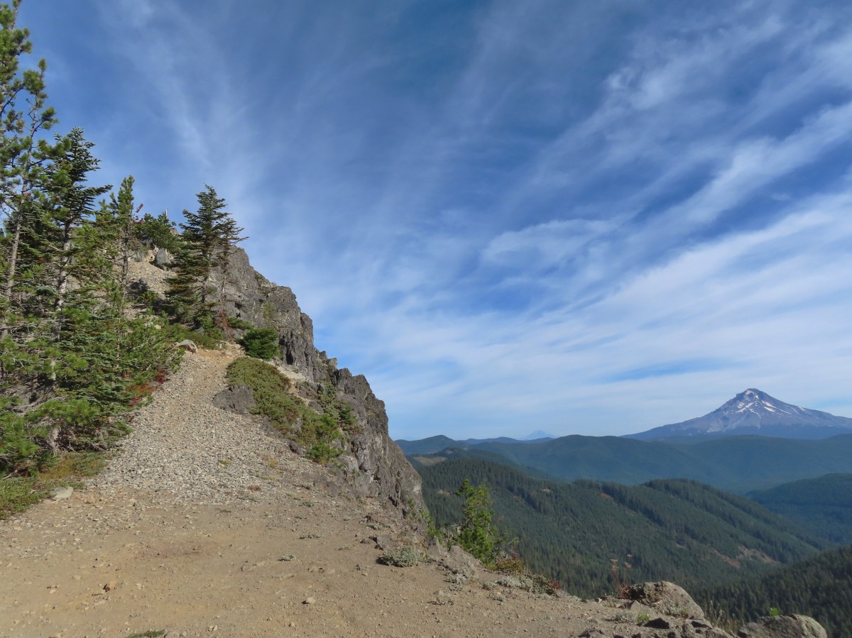
 Mt. Hood from the pullout.

We started up a rough road on the eastern side of the pullout.

While open the road is rough and 4wd is almost certainly a must (there was one pickup up at the end of the road and Heather saw a Subaru turn around and head down while I was exploring the rock outcrops.)


At the 0.4-mile mark the road turns sharply left while a jeep track launches steeply up a hill (where it really shouldn’t).
 The road continuing to the left.

Mt. Jefferson, the tops of the Three Sisters, and Three Fingered Jack from the road.
 Olallie Butte (post), Mt. Jefferson, the Three Sisters, and Three Fingered Jack.
I decided to head straight uphill on the jeep track to see what the view was like from the rocks here while Heather continued on the road to the former lookout site.
 Mt. Hood with Mt. Adams behind to the left.
 The view south toward Mt. Jefferson.

View along the rocky ridge.
I followed use trails along the ridge eventually gaining a view of the outcrop where the lookout site had been.
 Heather is the orange dot climbing up the side of the outcrop.
I had to drop down to a saddle where the road had ended. The pickup was parked here near a camp a couple of gentlemen had set up.
 Mt. Hood from the saddle.
I climbed up a fairly steep and rocky slope to join Heather at the former lookout site where we took a break and enjoyed the 360-degree view.
 Signal Buttes is the pointy peak on the left and Salmon Butte (post) is the rounded peak hump on the right.
 Salmon Butte now in the middle with Linney Butte the hump on the right of the double humps in the foreground and Devil’s Peak (post) the high point to the right of Linney Butte.
 Linney Butte, Devil’s Peak, Mt. Adams in the distance, and Mt. Hood.
 Wolf Peak in the foreground which is above Black Wolf Meadows.
 Mt. Jefferson from the former lookout site.
 Peaks in the Bull-of-the-Woods and Opal Creek Wilderness areas in the distance to the left and Fish Creek Mountain (post) in the distance to the right behind a ridge.
 The remains of the lookout on High Rock.
 A zoomed in shot of Mt. Adams.
 Mt. Rainier rising behind Devil’s Peak.
When it was time to head back we located a more gradual trail down to the saddle.


I stopped to take a picture of the golden-mantled ground squirrel posing on the large boulder. As I was taking the photo I noticed a pika dashing across the rocks. The pika is just barely visible below the lark dark rock to the left of the tree when zoomed in far enough.
 The ground squirrel watching us as we passed below.
 Skipper along the road on the way down.
 Aster
Aster

Red huckleberry leaves with Mt. Jefferson beyond.
The GPS read 1.3-miles for my hike here with a little under 350′ of elevation gain. This made the total for the day 6.6-miles with right around 850′ of elevation gain.

These hikes offered a nice variety of scenery free of crowds. Combining them provided a moderate day with enough hiking to warrant the 90+ mile drive from Salem, and now we can add three more places to the list of where we’ve been. We were treated to an unexpected post hike scene when a young black bear crossed Highway 224 near Promontory Park. At 11:30am we weren’t even considering that a bear might be crossing the road, but that made the third bear I’ve seen in the last 30 days and Heather’s 2nd. Happy Trails!


 Another reminder that overnight permits are required in the wilderness.
 Low clouds in the valley.
 Mt. Jefferson through some of the snags with a few surviving trees on the right.
 Mt. Jefferson from the junction, note the rock cairn on the left marking the PCT.
 The cairn at the junction.
 Triangulation Peak (
 Whitewater Lake
 Triangulation Point and Bocca Cave (Trailheads still closed.)
 Tarn 0.3-miles from the junction.
 Mt. Jefferson reflecting in the tarn.
 Ducks on the tarn.
 The Sentinel Hills with Park Butte behind to the right. The Whitewater Trail (
 The fires did open up fairly consistent views of the mountain.
 A few remaining penstemon blossoms.
 Heading down to the Russell Creek crossing.
 This can be a tricky crossing at times, but there was a makeshift bridge which made it fairly easy this time.
 Aster and pearly everlasting near the creek.
 We started seeing more trees that had survived the fire as we got closer to Jefferson Park.
 Gentians and aster
 Grass-of-parnassus
 There were patches of burned forest along this stretch.
 Approximately 0.4-miles from the junction the trail crosses Whitewater Creek.
 From the other side of Whitewater Creek the views of Mt. Jefferson are amazing.
 Based on the barred sides I believe this is a black-backed woodpecker.
 Unofficial use trails are an issue in Jefferson Park which has prompted the Forest Service to install a number of “Closed for Rehabilitation” sign such as the one on the left side of the trail.
 They’ve also added quite a few signs to indicated sanctioned trails. Typically in wilderness areas the Forest Service tries to keep signage to a minimum, but overuse has led them to add additional signs.
 Another sign with Park Butte in background.
 The last of the pointers for Scout Lake.
 PCT heading for Park Butte and Park Ridge.
 Russell Lake pointer.


 Painted Hills Unit
 Clarno Unit
 Blue Basin Unit


 B.C. Falls


 The first 0.2-miles followed a rough spur road.
 The trail starting at the 0.2-mile mark.


 An aster or fleabane
 Nettle-leaf giant hyssop
 Haze from wildfires burning in the Pacific Northwest.

 Corkscrew Falls
 One of the few trees that proved a little tricky.

 Smoke hanging over the East Fork Eagle Creek Valley.
 Penstemon
 The different shapes and colors of the peaks in the Wallowa Mountains never cease to impress.
 This section of trail appeared to have fallen victim to an avalanche that came down from the far side of the creek then up this one.
 Paintbrush
 Unnamed waterfall along East Fork Eagle Creek.
 The view improved a little as the day progressed.
 Coneflower along the trail.
 Fireweed
 Last of the mountain coyote mint.


 California tortoiseshell
 Fritillary butterfly
 Post marking the junction with the Hidden Lake Trail.


 View back across the East Fork Eagle Creek Valley.
 More obstacles were present along the Hidden Lake Trail.
 More trail damage.


 Gentians

 Looking back down at Moon Lake.

 On the other side of the ridge is Eagle Lake which we visited in 2023 (


 The Hidden Lake Trail continuing along the unnamed creek.
 There were still a few mountain heather blossoms.
 The unnamed lake.
 Heading cross country looking for the path of least resistance.
 My first view of Hidden Lake.
 Eagle Cap (

 Monkeyflower
 We set up for the afternoon.
 The lake looked to get pretty deep quickly.
 View from our dinner area.


 Gentians
 Last look at the lake.
 Grass of parnassus
 Hawkins Point on the left and Jackson Peak on the right.
 Moon Lake
 Big cricket
 Doe
Doe
 Unnamed creek near our campsite.
 View from camp in the morning. The eyes were looking at me from near the tree in the foreground to the left.
 Recrossing East Fork Eagle Creek.
 Heading into the haze.
 A healthy looking paintbrush.
 The bear had been walking up the outcrop in the shade in the middle of the picture.
 The bear is the black blotch on the rock in front of the tree at center.
 The bear just before it vanished behind the outcrop.
 Hawk in a snag.
 Corkscrew Falls
 Granite Cliff
 “Papa’s Camp” was located at the end of the 0.2-mile spur road.
 East Fork Eagle Creek from an old bridge near Papa’s Camp.
 Granite Cliff rising above East Fork Eagle Creek from the spur road to the trailhead.


 Aster
Aster
 The kiosk is straight ahead in the small gully.
 Cottontail
 In 2023 we had reached the kiosk from the Oregon Trail Ruts Trailhead along Highway 86.


 Looking back toward Panorama Point.


 Dotted is this trip, solid is 2023.


 There were hundreds of dragonflies along the trails which were much more welcome than the mosquitos that are a problem here in July and early August.
 The trail entering the wilderness.
 To the left through the trees is Mt. McLoughlin (
 The currently dry outlet creek of South Puck Lake.
 South Puck Lake from the Nannie Creek Trail.
 Someone had taken it upon themselves to craft their own sort of sign for the Puck Lakes Trail.

 The southern end of the lake was closed to camping for site restoration.
 South Puck Lake
 Use trail around the lake. The alignment of the former Puck Lakes Trail is further back from the lake.
 Two of three common mergansers that seemed to be calling the lake home for now.
 Our campsite for the night.
 Just after the trail began its descent it crossed a talus field.
 Mt. McLoughlin behind Luther Mountain.
 Shale Butte and Lucifer Peak (double hump is Lucifer).
 Pelican Butte straight ahead with peaks in the Mountain Lakes Wilderness (
 A faint Mt. Shasta through the haze.
 Agency Lake

 A good representation of the trail conditions between the talus slope and the Snow Lakes Trail. Nothing was overly problematic, but it did mean more effort on our part which in turn made it feel even warmer.
 Rock cairn marking the junction with the Snow Lake Trail.
 Looking back at the hillside we’d descended.
 One of several grouse that crossed the trail in front of us.
 Entering the fire scar from the 2014 “790 Fire”.
 Northwestern Rabbit-tobacco
 Martin Lake
 Pair of Lewis’s woodpeckers.
 One of the Snow Lakes below Luther Mountain.
 One of the Snow Lakes.
 After 1.4-miles we came to a junction with the Donna Lake Trail on the left. (Deep Lake is the lake visible below through the trees.) We’d turned down that trail on our previous visit, so we stayed right this time.
 One of several small, unnamed, bodies of water between the Donna Lake Trail junction and Margurette Lake.
 Blue beetle
 Hardhack
 Margurette Lake
 Margurette Lake
 Coming up on the junction.
 The Sky Lakes Trail.
 Trapper Lake
 The Donna Lake Trail to the right.
 Donna Lake

 Luther Mountain from Deep Lake.
 Tiny western toad
 Signs of Fall.
 Lousewort
 Young grouse

 Martin Lake
 Back at the Nannie Creek Trail junction.
 It was increasingly looking like a shower or two might happen.
 A deep zoom in at Mt. Shasta.

 Pine white
 Spotted sandpiper
 The three resident mergansers.
 The abandoned Puck Lakes Trail.
 A dark cloud passing over the Puck Lakes (no rain).
 North Puck Lake
 North Puck Lake


 Heather in the tent packing up.
 A sliver of the Moon reflecting in the lake at 5:48am.
 6:06am
 North Puck Lake at 6:22am as we set off.
 Luther Mountain from the Nannie Creek Trail in the morning.
 Dark blue = day one, magenta = day two, light blue = previous visit.

 Map at the trailhead signboard and wilderness permit station.
 Trail sign at the split of the East and West Fork trails.

 Trail sign for the East Fork Wallowa Trail at a junction with a gravel road.
 Ghost pipe
 Entering into the Wallowa-Whitman National Forest.

 Chief Joseph Mountain and Wallowa Lake
 I never saw any but I heard a number of pikas in the rock fields.
 Switchback
 Rock clematis seed heads.
 Bridge at the upper end of the access road that I had passed earlier.
 The lower section of the waterfall from the bridge.

 The access road bridge from the switchback.
 East Fork Wallowa River Forebay
 Interpretive sign at the forebay.
 Aster
Aster The trail entering the

 Elderberry and baneberry
 Zoomed in photo.
 Small meadow along the trail.
 Aneroid Mountain in the distance.
 Mountain larkspur
 Pika underneath some raspberries.
 Pika
Pika A few lupine were still blooming along the trail.
 Doe in a small meadow along the trail.
 Tall mountain bluebells
 The damaged footbridge.


 East Fork Wallowa River
 The inbound and outbound forks rejoining.
 East Fork Wallowa River flowing through a meadow along the trail.
 Goldenrod
 Unnamed creek crossing.
 American sawort
 Another doe in a meadow.
 A hazy view of Aneroid Mountain.
 Pearly everlasting along the trail.
 East Peak (
 A closer look at East Peak.


 The benches.
 Groundsel along the trail.
 A boat docked on the lakeshore in the distance.
 An inlet creek to the lake near the boat dock.
 East Peak from Aneroid Lake.


 Signs for Camp Halton at the actual junction with the East Fork Wallowa Trail.

 Hammond’s flycatcher
 East Peak
 Lewis monkeyflower
 Aneroid Mountain
 Pollinator on a flower.
 The split trail.
 The outbound trail dropped quite steeply before meeting back up with the inbound trail.
 The damaged bridge from the other side.
 Fritillary butterfly
 A comma butterfly
 Golden-mantled ground squirrel
 Mount Howard
 Coneflower
 Wallowa Lake
 Quaking aspen
 Arriving back at the trailhead.


 The trail passes through the Shady Campground.
 Lostine River
 Unnamed creek crossing.

 Thimbleberry
 One of the switchbacks.
 Climbing into the sunlight.
 Possibly a Cassin’s vireo.
 Another switchback.
 Fireweed
 Monkshood
 Twisted stalk
 Eagle Cap (
 Looking down from the trail.
 Paintbrush
 Chipmunk
 The trail turning uphill ahead to start the steep climb.
 Meadow along a brief section of reasonably graded trail.
 Nuttal’s linanthus


 The pass in view.
 Twin Peaks to the left over the shoulder of the ridge.
 The trail down to Maxwell Lake.
 Ground squirrel on alert.
 Maxwell Lake

 Aster along the outlet creek.
 Gentians
 Island in Maxwell Lake.
 The view from the granite outcrop.
 Looking back at the pass from the outcrop.
 Last of the snow at Maxwell Lake.
 Trail along Maxwell Lake.
 Trail to Jackson Lake.
 Jackson Lake
 False hellebore
 Pika raising a warning call. Interestingly the pikas in the Wallowas make a sound that we don’t recall hearing from pikas in other areas. It was almost as if they had their own regional dialect.
 Passing back over the granite outcrop.
 Maxwell Lake’s outlet creek.
 Trout in the outlet stream.
 One last look at Maxwell Lake.
 The view from the pass on the way back.
 Heading down the steep section.
 The afternoon lighting on the ridge across the Lostine River really brought out the colors.
 Eagle Cap way up the valley.
 Heather counted at least seven significant drops on a creek cascading down the far hillside.
 Fritillary
 Canada jay
 Police car moth
 Back at the bridge over the Lostine River.
 Lostine River
 The Maxwell Lake Trailhead in the afternoon.


 The trail entered the

 Lewis monkeyflower
 Eagle Cap (
 Chipmunk
 One of the switchbacks.
 Western tanager
 Pearly everlasting
 Paintbrush
 Baneberry
 Pika
Pika
 Bowman Creek
 Grass of parnassus
 The trail crossing Bowman Creek.
 Arnica
 Monkeyflower
 Bees on American sawort.


 Golden-mantled ground squirrel
 Another pika.
 Elderberry
 The lefthand fork led to a campsite and meadows in the basin.
 Gentians
 Meadow in Brownie Basin.
 The junction with the Chimney-Wood Trail.

 One of several pine siskins that were in these plants.
 Aster
Aster
 Fritillary
 Lupine and aster
 Butterfly on pearly everlasting

 Another western tanager.
 Gentians and St. Johnswort
 Lower Laverty Lake
 A patch of fireweed above the lake.
 Hooded ladies’-tresses
 American kestral
 Lower Laverty Lake
 Twin Peaks across the Lostine River valley.
 Eagle Cap at the far end of the valley.
 Heading for Chimney Lake.
 Chimney Lake
 Gentians along the lakeshore.
 The rocks ahead where we took our break.
 Islands in Chimney Lake.
 No matter how cute they are, please don’t feed the wildlife (
 Sulphur butterfly
 We heard more pikas than we saw. Here is the one, blurry, photo I managed to get.
 Milbert’s tortoiseshell
 Golden-mantle managing to feed itself.
 Twin Peaks
 Aster
Aster
 California tortoiseshell
 Grouse
 A comma, possible green comma.
 Back at the bridge over the Lostine River.
 Lostine River in the afternoon.


 This pointer refers to trail 1880 as “Pine Creek” but other signs and the Forest Service website refer to it as “Pine Lakes”.
 This one says Pine Lakes.
 Sign for the Packstation.
 Squirrel with breakfast at the packstation.
 Old footbridge over a dry creek bed. It didn’t look particularly safe so I stuck to the road.
 The dry creek bed crossing.
 Black cows on the trail ahead.
 Coneflower
 Snowberry
 West Fork Pine Creek
 Formation on the hillside.
 Western clematis
 Paintbrush
 Fireweed
 The bridge felt stable despite being slanted at a 45-degree angle.
 View from the trail.

 The second bridge.
 West Fork Pine Creek
 Heather caught this cool cloud from her currently cow free hike. (She would run into them later where they’d ducked off the trail in front of me.)
 Looking back down at the campsite.
 The use trail straight ahead at the switchback.

 The base of Chute Falls.


 Looking back down the valley.
 View up the valley.
 Wilderness sign on the tree marking the boundary.
 The Pine Lakes are back up there somewhere.
 Somewhere on the other side of the peaks on the left is the Schneider Cabin where we’d hiked the day before.
 Cliffs above the trail.
 I spy mountain goats!
 A zoomed in photo of the mountain goats.


 I believe that is Cornucopia Peak on the left.
 Going up.
 Fireweed above the trail.
 Paintbrush along the trail.
 The forest on the other side of the pass.
 West Fork Pine Creek
 There was a large waterfall flowing down from the outlet of the Pine Lakes. (Not West Fork Pine Creek whose headwaters were beyond the meadowed basin.
 West Fork Pine Creek begins somewhere above the basin at the far end.
 Rock formations along the cliffs.
 Arnica and pearly everlasting
 I tried to get a clearer look at the large waterfall but couldn’t find a clear line of sight.

 Gentians along the trail.
 Evidence of an avalanche at the far end of this meadow. It took a lot of trail maintenance to clear the snapped trees from the trail.
 Wildflowers lining the trail.
 A doe that turned out to be on the trail above me. There was a switchback just ahead of where I was.


 The forest in the basin.
 The Pine Lakes are in the basin ahead.
 Arnica and aster?
 Monkshood
 Seep along the trail.
 Grass of parnassus
 American sawort
 Something had been bedded down in this little bowl below the trail.
 Goldenrod
 The valley I’d come up to the right.
 Nearly 5-miles from Chute Falls I arrived at the dam at the outlet of Lower Pine Lake. A number of lakes in the Wallows were dammed to control water flow to the surrounding communities.
 Lower Pine Lake

 Lower Pine Lake
 Lower Pine Lake from between the two lakes.
 Upper Pine Lake from the same spot.


 The view from my break spot.
 Shrubby cinquefoil
 White mariposa lily, the only one I spotted, and I’d missed it on the way up.
 Yellow columbine, I also missed this on the first pass.
 Dusky flycacther
 A meadow and the forest in the lower basin.
 Fritillary on pearly everlasting
 Trail maintenance in the avalanche section.
 Loved the rock colors in the area.
 I’m guessing some sort of wren.
 Caterpillers
 Herding the cattle back past the damaged bridge.
 West Fork Pine Creek.
 The footbridge across the East Fork Pine Creek ahead. We’d left the cows behind here and made our way back to the trailhead.
